Stephenson Mountain Topo Map Oregon
To zoom in, hover over the map of Stephenson Mountain
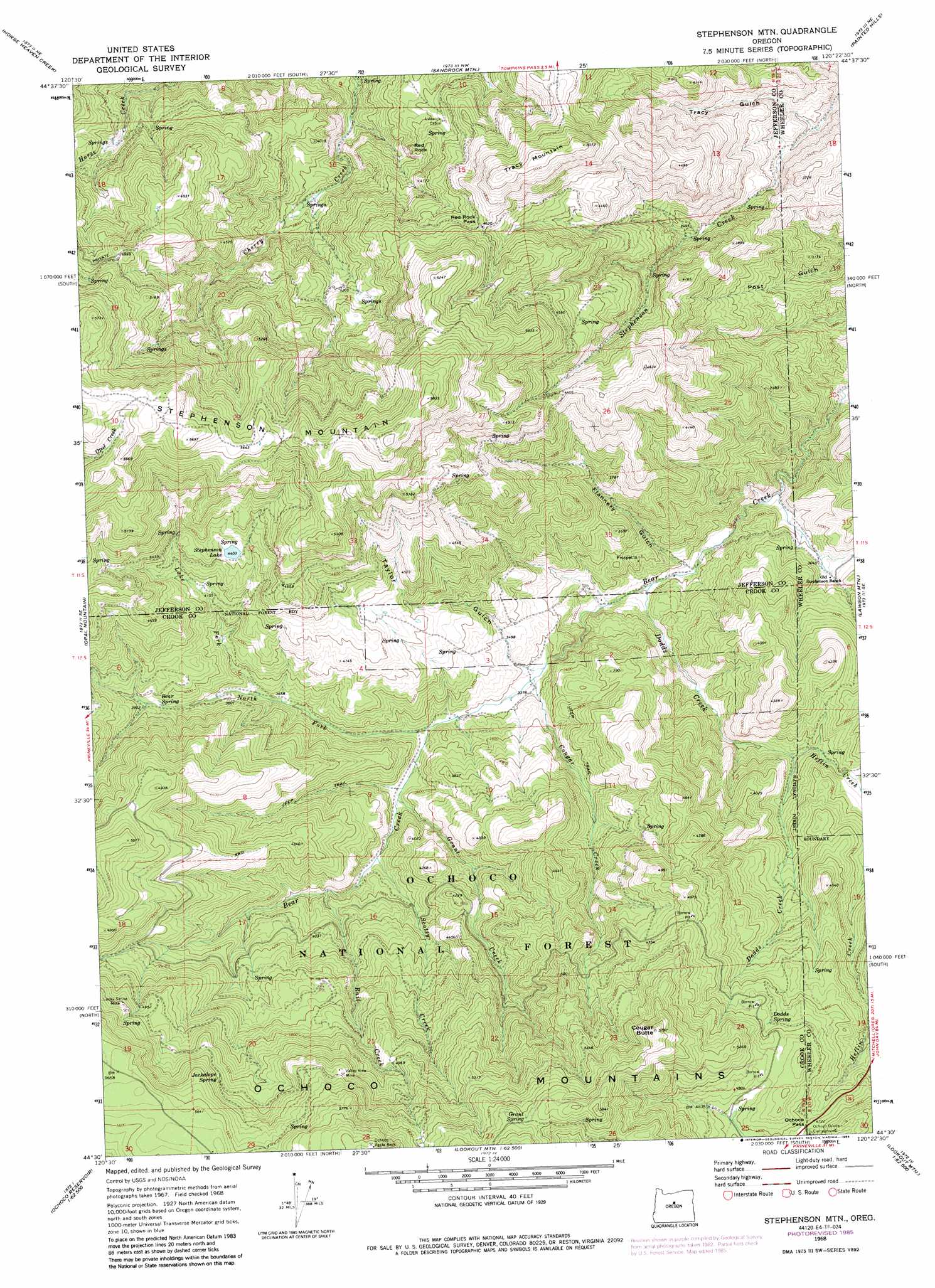
USGS Topo Quad 44120e4 - 1:24,000 scale
| Topo Map Name: | Stephenson Mountain |
| USGS Topo Quad ID: | 44120e4 |
| Print Size: | ca. 21 1/4" wide x 27" high |
| Southeast Coordinates: | 44.5° N latitude / 120.375° W longitude |
| Map Center Coordinates: | 44.5625° N latitude / 120.4375° W longitude |
| U.S. State: | OR |
| Filename: | o44120e4.jpg |
| Download Map JPG Image: | Stephenson Mountain topo map 1:24,000 scale |
| Map Type: | Topographic |
| Topo Series: | 7.5´ |
| Map Scale: | 1:24,000 |
| Source of Map Images: | United States Geological Survey (USGS) |
| Alternate Map Versions: |
Stephenson Mtn OR 1968, updated 1972 Download PDF Buy paper map Stephenson Mtn. OR 1968, updated 1985 Download PDF Buy paper map Stephenson Mtn. OR 1992, updated 1997 Download PDF Buy paper map Stephenson Mountain OR 2011 Download PDF Buy paper map Stephenson Mountain OR 2014 Download PDF Buy paper map |
| FStopo: | US Forest Service topo Stephenson Mountain is available: Download FStopo PDF Download FStopo TIF |
1:24,000 Topo Quads surrounding Stephenson Mountain
Donnybrook |
Arrastra Butte |
Muddy Ranch |
Jennies Peak |
Rowe Creek |
Axehandle Butte |
Horse Heaven Creek |
Sandrock Mountain |
Painted Hills |
Sutton Mountain |
Dutchman Creek |
Opal Mountain |
Stephenson Mountain |
Lawson Mountain |
Mitchell |
Salt Butte |
Wildcat Mountain |
Whistler Point |
Ochoco Butte |
Mount Pisgah |
Ochoco Reservoir |
Cadle Butte |
Gerow Butte |
Lookout Mountain |
Williams Prairie |
> Back to 44120e1 at 1:100,000 scale
> Back to 44120a1 at 1:250,000 scale
> Back to U.S. Topo Maps home
Stephenson Mountain topo map: Gazetteer
Stephenson Mountain: Gaps
Ochoco Pass elevation 1442m 4730′Red Rock Pass elevation 1398m 4586′
Stephenson Mountain: Mines
Lucky Strike Mine elevation 1523m 4996′Ochoco Agate Beds elevation 1842m 6043′
Valley View Mine elevation 1638m 5374′
Stephenson Mountain: Reservoirs
Stephenson Lake elevation 1350m 4429′Stephenson Mountain: Springs
Bear Spring elevation 1187m 3894′Dodds Spring elevation 1449m 4753′
Grant Spring elevation 1721m 5646′
Jackalope Spring elevation 1587m 5206′
Stephenson Mountain: Streams
Cougar Creek elevation 1019m 3343′Dodds Creek elevation 910m 2985′
Grant Creek elevation 1076m 3530′
Heflin Creek elevation 1117m 3664′
Lake Fork elevation 1118m 3667′
North Fork Bear Creek elevation 1052m 3451′
Rail Creek elevation 1132m 3713′
Scotty Creek elevation 1106m 3628′
Stephenson Mountain: Summits
Cougar Butte elevation 1759m 5770′Red Rock elevation 1167m 3828′
Stephenson Mountain elevation 1769m 5803′
Tracy Mountain elevation 1539m 5049′
Stephenson Mountain: Valleys
Flannery Gulch elevation 902m 2959′Taylor Gulch elevation 1026m 3366′
Tracy Gulch elevation 893m 2929′
Stephenson Mountain digital topo map on disk
Buy this Stephenson Mountain topo map showing relief, roads, GPS coordinates and other geographical features, as a high-resolution digital map file on DVD: