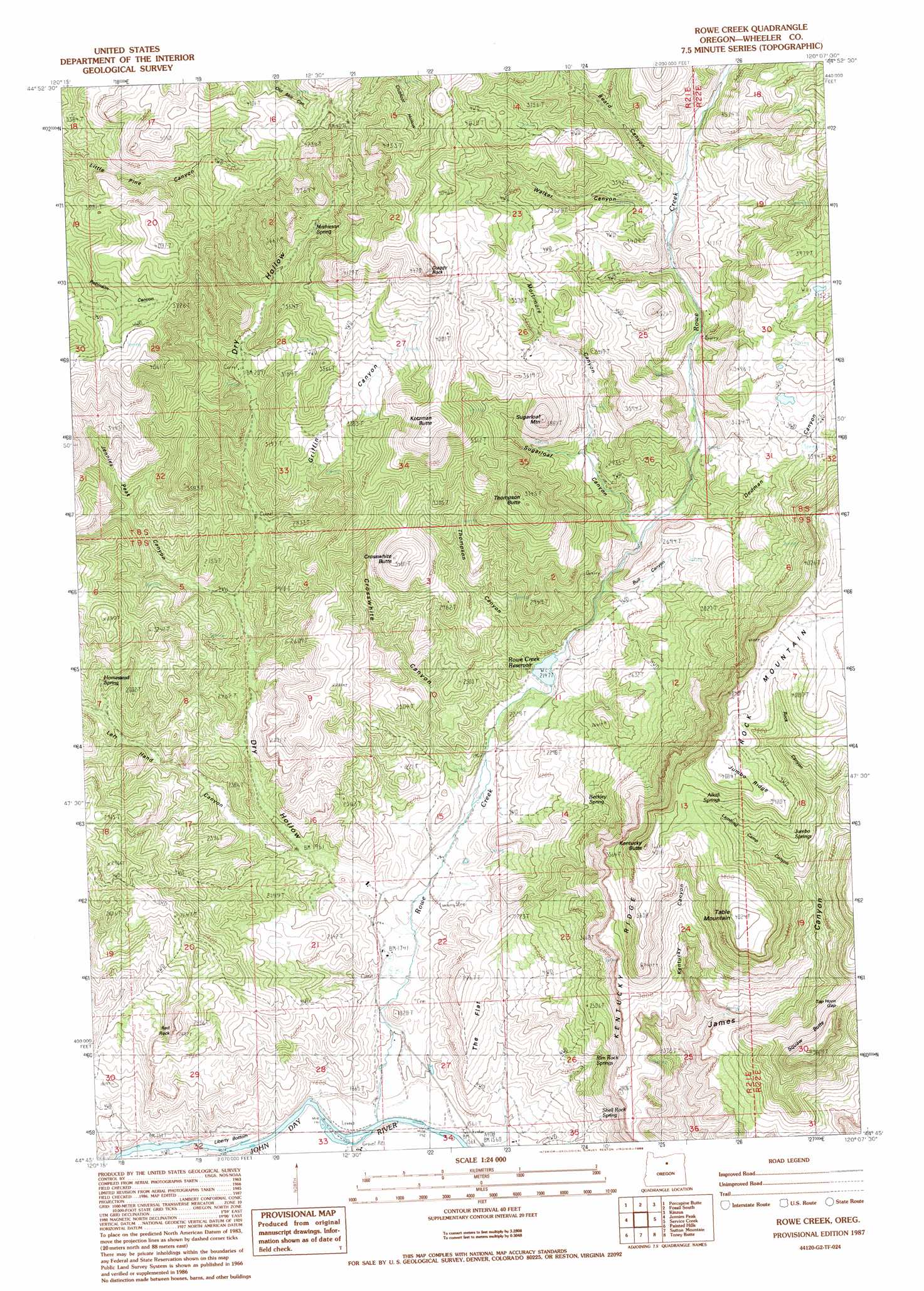
Rowe Creek Topo Map Oregon
To zoom in, hover over the map of Rowe Creek
USGS Topo Quad 44120g2 - 1:24,000 scale
| Topo Map Name: | Rowe Creek |
| USGS Topo Quad ID: | 44120g2 |
| Print Size: | ca. 21 1/4" wide x 27" high |
| Southeast Coordinates: | 44.75° N latitude / 120.125° W longitude |
| Map Center Coordinates: | 44.8125° N latitude / 120.1875° W longitude |
| U.S. State: | OR |
| Filename: | o44120g2.jpg |
| Download Map JPG Image: | Rowe Creek topo map 1:24,000 scale |
| Map Type: | Topographic |
| Topo Series: | 7.5´ |
| Map Scale: | 1:24,000 |
| Source of Map Images: | United States Geological Survey (USGS) |
| Alternate Map Versions: |
Rowe Creek OR 1987, updated 1988 Download PDF Buy paper map Rowe Creek OR 2011 Download PDF Buy paper map Rowe Creek OR 2014 Download PDF Buy paper map |
1:24,000 Topo Quads surrounding Rowe Creek
Chimney Springs |
Buckhorn Canyon |
Fossil North |
Salmon Fork |
Lonerock |
Clarno |
Porcupine Butte |
Fossil South |
Kinzua |
Wheeler Point |
Muddy Ranch |
Jennies Peak |
Rowe Creek |
Service Creek |
Massacre Mountain |
Sandrock Mountain |
Painted Hills |
Sutton Mountain |
Toney Butte |
Richmond |
Stephenson Mountain |
Lawson Mountain |
Mitchell |
Keyes Mountain |
Frog Hollow |
> Back to 44120e1 at 1:100,000 scale
> Back to 44120a1 at 1:250,000 scale
> Back to U.S. Topo Maps home
Rowe Creek topo map: Gazetteer
Rowe Creek: Dams
Rowe Creek Dam elevation 654m 2145′Rowe Creek: Flats
Liberty Bottom elevation 463m 1519′The Flat elevation 596m 1955′
Rowe Creek: Gaps
Tap Horn Gap elevation 1059m 3474′Rowe Creek: Pillars
Craggy Rock elevation 1328m 4356′Rowe Creek: Reservoirs
Rowe Creek Reservoir elevation 654m 2145′Rowe Creek: Ridges
Jumbo Ridge elevation 1226m 4022′Kentucky Ridge elevation 1091m 3579′
Rock Mountain elevation 1206m 3956′
Rowe Creek: Springs
Alkali Springs elevation 1128m 3700′Beckley Spring elevation 723m 2372′
Homestead Spring elevation 791m 2595′
Jumbo Springs elevation 1136m 3727′
Mathieson Spring elevation 1043m 3421′
Rim Rock Springs elevation 649m 2129′
Shell Rock Spring elevation 639m 2096′
Rowe Creek: Streams
Rowe Creek elevation 466m 1528′Rowe Creek: Summits
Crosswhite Butte elevation 1033m 3389′Kentucky Butte elevation 1183m 3881′
Kotzman Butte elevation 1262m 4140′
Red Rock elevation 744m 2440′
Squaw Butte elevation 1162m 3812′
Sugarloaf Mountain elevation 1143m 3750′
Table Mountain elevation 1216m 3989′
Thompson Butte elevation 1131m 3710′
Rowe Creek: Valleys
Beard Canyon elevation 951m 3120′Bull Canyon elevation 705m 2312′
Crosswhite Canyon elevation 591m 1938′
Dedman Canyon elevation 757m 2483′
Dry Hollow elevation 552m 1811′
Griffin Canyon elevation 763m 2503′
Jennies Peak Canyon elevation 747m 2450′
Kentucky Canyon elevation 741m 2431′
Lambing Camp Canyon elevation 968m 3175′
Left Hand Canyon elevation 600m 1968′
Mortimore Canyon elevation 867m 2844′
Rock Canyon elevation 1063m 3487′
Sugarloaf Canyon elevation 746m 2447′
Thompson Canyon elevation 679m 2227′
Walker Canyon elevation 928m 3044′
Rowe Creek digital topo map on disk
Buy this Rowe Creek topo map showing relief, roads, GPS coordinates and other geographical features, as a high-resolution digital map file on DVD: