Kinzua Topo Map Oregon
To zoom in, hover over the map of Kinzua
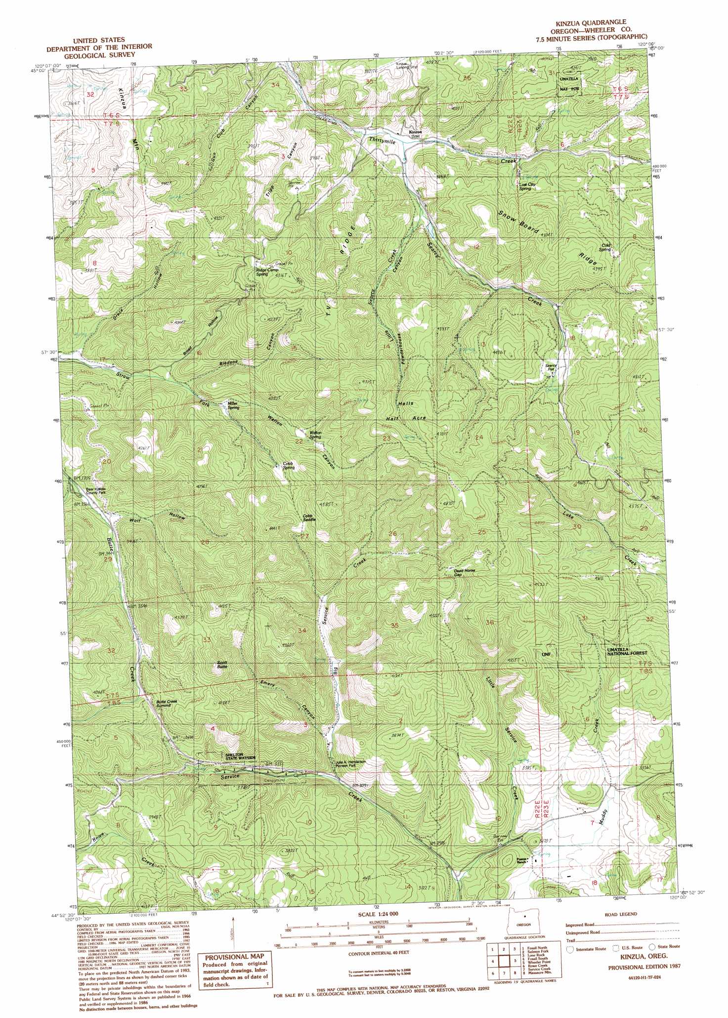
USGS Topo Quad 44120h1 - 1:24,000 scale
| Topo Map Name: | Kinzua |
| USGS Topo Quad ID: | 44120h1 |
| Print Size: | ca. 21 1/4" wide x 27" high |
| Southeast Coordinates: | 44.875° N latitude / 120° W longitude |
| Map Center Coordinates: | 44.9375° N latitude / 120.0625° W longitude |
| U.S. State: | OR |
| Filename: | o44120h1.jpg |
| Download Map JPG Image: | Kinzua topo map 1:24,000 scale |
| Map Type: | Topographic |
| Topo Series: | 7.5´ |
| Map Scale: | 1:24,000 |
| Source of Map Images: | United States Geological Survey (USGS) |
| Alternate Map Versions: |
Kinzua OR 1987, updated 1988 Download PDF Buy paper map Kinzua OR 2011 Download PDF Buy paper map Kinzua OR 2014 Download PDF Buy paper map |
1:24,000 Topo Quads surrounding Kinzua
Schott Canyon |
Condon |
Matney Flat |
Lone Rock Creek |
Buttermilk Canyon |
Buckhorn Canyon |
Fossil North |
Salmon Fork |
Lonerock |
Lefevre Prairie |
Porcupine Butte |
Fossil South |
Kinzua |
Wheeler Point |
Collins Butte |
Jennies Peak |
Rowe Creek |
Service Creek |
Massacre Mountain |
Spray |
Painted Hills |
Sutton Mountain |
Toney Butte |
Richmond |
Johnson Heights |
> Back to 44120e1 at 1:100,000 scale
> Back to 44120a1 at 1:250,000 scale
> Back to U.S. Topo Maps home
Kinzua topo map: Gazetteer
Kinzua: Airports
Kinzua General Aviation Recreational Airport elevation 1182m 3877′Kinzua: Areas
Hells Half Acre elevation 1394m 4573′Kinzua: Dams
Kinzua Dam (historical) elevation 1077m 3533′Kinzua: Flats
Searcy Flat elevation 1233m 4045′Kinzua: Gaps
Cobb Saddle elevation 1266m 4153′Dead Horse Gap elevation 1310m 4297′
Kinzua: Parks
Bear Hollow County Park elevation 1012m 3320′Julia A Henderson Pioneer Park elevation 963m 3159′
Pioneer Park elevation 993m 3257′
Shelton Wayside County Park elevation 1030m 3379′
Kinzua: Populated Places
Kinzua (historical) elevation 1037m 3402′Kinzua: Post Offices
Kinzua Post Office (historical) elevation 1037m 3402′Kinzua: Reservoirs
Kinzua Reservoir (historical) elevation 1077m 3533′Kinzua: Ridges
T V Ridge elevation 1254m 4114′Kinzua: Springs
Cobb Springs elevation 1198m 3930′Lost City Spring elevation 1122m 3681′
Miller Spring elevation 1068m 3503′
Ridge Camp Spring elevation 1231m 4038′
Walton Spring elevation 1175m 3854′
Kinzua: Streams
Big Service Creek elevation 950m 3116′Little Searcy Creek elevation 1090m 3576′
Little Service Creek elevation 869m 2851′
Muddy Creek elevation 906m 2972′
Searcy Creek elevation 1042m 3418′
Kinzua: Summits
Butte Creek Summit elevation 1228m 4028′Kinzua Mountain elevation 1280m 4199′
Scott Butte elevation 1276m 4186′
Kinzua: Valleys
Bledsoe Canyon elevation 1045m 3428′Broad Hollow elevation 1033m 3389′
Drace Hollow elevation 992m 3254′
Emery Canyon elevation 1009m 3310′
Powder House Canyon elevation 1090m 3576′
Tripp Canyon elevation 1064m 3490′
Walton Canyon elevation 1080m 3543′
Wolf Hollow elevation 1031m 3382′
Kinzua digital topo map on disk
Buy this Kinzua topo map showing relief, roads, GPS coordinates and other geographical features, as a high-resolution digital map file on DVD: