Bend Topo Map Oregon
To zoom in, hover over the map of Bend
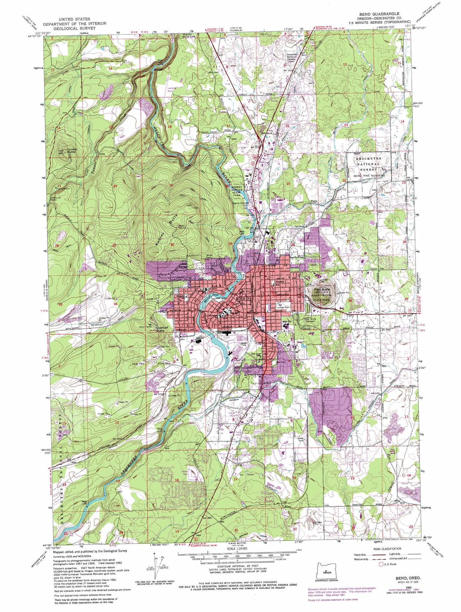
USGS Topo Quad 44121a3 - 1:24,000 scale
| Topo Map Name: | Bend |
| USGS Topo Quad ID: | 44121a3 |
| Print Size: | ca. 21 1/4" wide x 27" high |
| Southeast Coordinates: | 44° N latitude / 121.25° W longitude |
| Map Center Coordinates: | 44.0625° N latitude / 121.3125° W longitude |
| U.S. State: | OR |
| Filename: | o44121a3.jpg |
| Download Map JPG Image: | Bend topo map 1:24,000 scale |
| Map Type: | Topographic |
| Topo Series: | 7.5´ |
| Map Scale: | 1:24,000 |
| Source of Map Images: | United States Geological Survey (USGS) |
| Alternate Map Versions: |
Bend OR 1962, updated 1963 Download PDF Buy paper map Bend OR 1962, updated 1975 Download PDF Buy paper map Bend OR 1962, updated 1977 Download PDF Buy paper map Bend OR 1962, updated 1982 Download PDF Buy paper map Bend OR 1962, updated 1986 Download PDF Buy paper map Bend OR 1962, updated 1986 Download PDF Buy paper map Bend OR 2011 Download PDF Buy paper map Bend OR 2014 Download PDF Buy paper map |
| FStopo: | US Forest Service topo Bend is available: Download FStopo PDF Download FStopo TIF |
1:24,000 Topo Quads surrounding Bend
Sisters |
Henkle Butte |
Cline Falls |
Redmond |
O'Neil |
Three Creek Butte |
Tumalo Dam |
Tumalo |
Forked Horn Butte |
Powell Butte |
Tumalo Falls |
Shevlin Park |
Bend |
Bend Airport |
Alfalfa |
Wanoga Butte |
Benham Falls |
Lava Butte |
Kelsey Butte |
Horse Ridge |
Pistol Butte |
Anns Butte |
Lava Cast Forest |
Fuzztail Butte |
Evans Well |
> Back to 44121a1 at 1:100,000 scale
> Back to 44120a1 at 1:250,000 scale
> Back to U.S. Topo Maps home
Bend topo map: Gazetteer
Bend: Airports
D M Stevenson Ranch Airstrip (historical) elevation 1149m 3769′Gopher Gulch Airstrip elevation 1060m 3477′
Saint Charles Medical Center Heliport elevation 1093m 3585′
Bend: Canals
Bend Feed Canal elevation 1064m 3490′Swalley Canal elevation 1048m 3438′
Bend: Dams
Bend Power Dam elevation 1092m 3582′North Unit Diversion Dam elevation 1084m 3556′
Bend: Parks
Archie Briggs Canyon Open Space elevation 1058m 3471′Awbrey Village Park elevation 1185m 3887′
Bend Senior Center elevation 1134m 3720′
Blakely Park elevation 1128m 3700′
Brandis Square elevation 1110m 3641′
Brooks Park elevation 1092m 3582′
Canal Park elevation 1059m 3474′
Columbia Park elevation 1097m 3599′
Deschutes River Trail elevation 1059m 3474′
Dohema Canoe Access elevation 1099m 3605′
Drake Park elevation 1096m 3595′
First Street Rapids Park elevation 1091m 3579′
Foxborough Park elevation 1138m 3733′
Genna Stadium elevation 1131m 3710′
Harmon Park elevation 1099m 3605′
Hillside Park elevation 1163m 3815′
Hixon Park Block elevation 1106m 3628′
Hollinshead Park elevation 1101m 3612′
Juniper Park elevation 1111m 3645′
Juniper Swim and Fitness Center elevation 1110m 3641′
Kiwanis Park elevation 1131m 3710′
Larkspur Trail elevation 1122m 3681′
McKay Park elevation 1099m 3605′
Pacific Park elevation 1103m 3618′
Pageant Park elevation 1094m 3589′
Pilot Butte State Scenic Viewpoint elevation 1251m 4104′
Pinewood Park elevation 1122m 3681′
Pioneer Park elevation 1114m 3654′
Ponderosa Park elevation 1124m 3687′
Providence Park elevation 1101m 3612′
Railroad Park elevation 1122m 3681′
Riverview Park elevation 1090m 3576′
Sawyer Park elevation 1075m 3526′
Skyliners Park Sports Complex elevation 1142m 3746′
Stover Park elevation 1081m 3546′
Summit Park elevation 1246m 4087′
Sunset View Park elevation 1128m 3700′
Sylvan Park elevation 1259m 4130′
Woodland Pond Park elevation 1125m 3690′
Woodriver Park I & II elevation 1103m 3618′
Bend: Populated Places
Bend elevation 1106m 3628′Bend: Post Offices
Bend Post Office elevation 1106m 3628′Downtown Post Office elevation 1106m 3628′
Bend: Reservoirs
Mirror Pond elevation 1092m 3582′Bend: Ridges
Awbrey Butte elevation 1273m 4176′Bend: Streams
Tumalo Creek elevation 987m 3238′Bend: Summits
Overturf Butte elevation 1183m 3881′Pilot Butte elevation 1259m 4130′
Tumalo Butte elevation 1187m 3894′
Bend digital topo map on disk
Buy this Bend topo map showing relief, roads, GPS coordinates and other geographical features, as a high-resolution digital map file on DVD: