Clear Lake Topo Map Oregon
To zoom in, hover over the map of Clear Lake
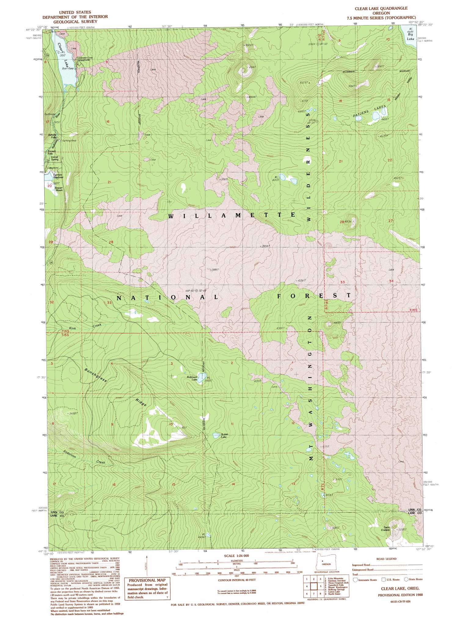
USGS Topo Quad 44121c8 - 1:24,000 scale
| Topo Map Name: | Clear Lake |
| USGS Topo Quad ID: | 44121c8 |
| Print Size: | ca. 21 1/4" wide x 27" high |
| Southeast Coordinates: | 44.25° N latitude / 121.875° W longitude |
| Map Center Coordinates: | 44.3125° N latitude / 121.9375° W longitude |
| U.S. State: | OR |
| Filename: | o44121c8.jpg |
| Download Map JPG Image: | Clear Lake topo map 1:24,000 scale |
| Map Type: | Topographic |
| Topo Series: | 7.5´ |
| Map Scale: | 1:24,000 |
| Source of Map Images: | United States Geological Survey (USGS) |
| Alternate Map Versions: |
Clear Lake OR 1988, updated 1988 Download PDF Buy paper map Clear Lake OR 1997, updated 2001 Download PDF Buy paper map Clear Lake OR 2011 Download PDF Buy paper map Clear Lake OR 2014 Download PDF Buy paper map |
| FStopo: | US Forest Service topo Clear Lake is available: Download FStopo PDF Download FStopo TIF |
1:24,000 Topo Quads surrounding Clear Lake
Chimney Peak |
Coffin Mountain |
Marion Forks |
Marion Lake |
Candle Creek |
Harter Mountain |
Echo Mountain |
Santiam Junction |
Three Fingered Jack |
Black Butte |
Carpenter Mountain |
Tamolitch Falls |
Clear Lake |
Mount Washington |
Black Crater |
Mckenzie Bridge |
Belknap Springs |
Linton Lake |
North Sister |
Trout Creek Butte |
Cougar Reservoir |
French Mountain |
Substitute Point |
South Sister |
Lake Geneva |
> Back to 44121a1 at 1:100,000 scale
> Back to 44120a1 at 1:250,000 scale
> Back to U.S. Topo Maps home
Clear Lake topo map: Gazetteer
Clear Lake: Craters
Twin Craters elevation 1566m 5137′Clear Lake: Falls
Sahalie Falls elevation 867m 2844′Clear Lake: Lakes
Clear Lake elevation 919m 3015′Kuitan Lake elevation 1277m 4189′
Lard Lake elevation 1494m 4901′
Patjens Lakes elevation 1364m 4475′
Robinson Lake elevation 1191m 3907′
Clear Lake: Lavas
Underwater Forest elevation 927m 3041′Clear Lake: Ridges
Bunchgrass Ridge elevation 1078m 3536′Clear Lake: Springs
Icecap Spring elevation 838m 2749′Clear Lake: Streams
Ice Cap Creek elevation 803m 2634′Clear Lake: Swamps
Beaver Marsh elevation 803m 2634′Clear Lake: Trails
Anderson Ridge Trail elevation 1134m 3720′Deer Butte Trail elevation 1369m 4491′
Patjens Lakes Trail elevation 1403m 4603′
Pocket Way elevation 1371m 4498′
Thirsty Camp Trail elevation 1398m 4586′
Clear Lake digital topo map on disk
Buy this Clear Lake topo map showing relief, roads, GPS coordinates and other geographical features, as a high-resolution digital map file on DVD: