Round Butte Dam Topo Map Oregon
To zoom in, hover over the map of Round Butte Dam
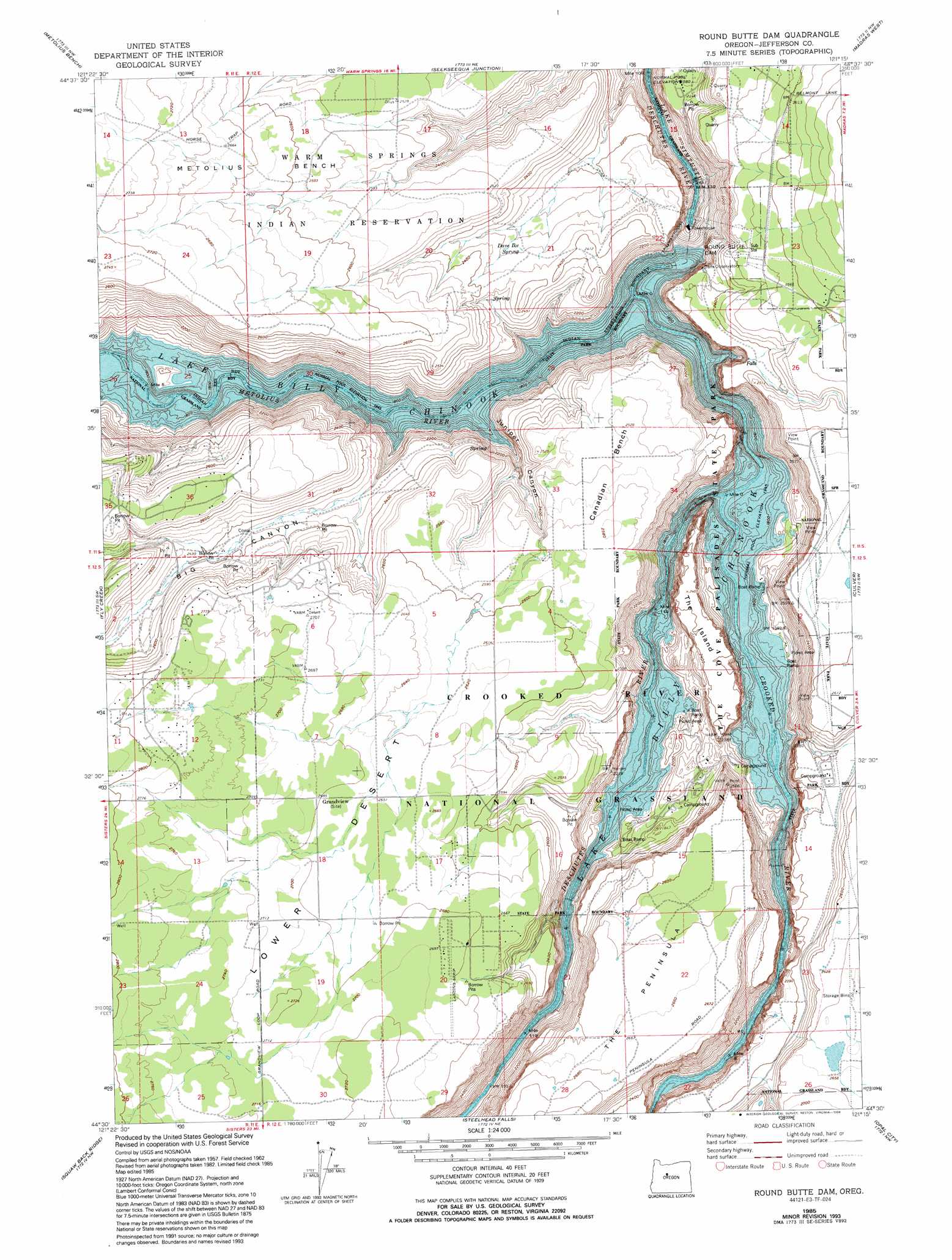
USGS Topo Quad 44121e3 - 1:24,000 scale
| Topo Map Name: | Round Butte Dam |
| USGS Topo Quad ID: | 44121e3 |
| Print Size: | ca. 21 1/4" wide x 27" high |
| Southeast Coordinates: | 44.5° N latitude / 121.25° W longitude |
| Map Center Coordinates: | 44.5625° N latitude / 121.3125° W longitude |
| U.S. State: | OR |
| Filename: | o44121e3.jpg |
| Download Map JPG Image: | Round Butte Dam topo map 1:24,000 scale |
| Map Type: | Topographic |
| Topo Series: | 7.5´ |
| Map Scale: | 1:24,000 |
| Source of Map Images: | United States Geological Survey (USGS) |
| Alternate Map Versions: |
Round Butte Dam OR 1962, updated 1964 Download PDF Buy paper map Round Butte Dam OR 1962, updated 1978 Download PDF Buy paper map Round Butte Dam OR 1976, updated 1981 Download PDF Buy paper map Round Butte Dam OR 1985, updated 1986 Download PDF Buy paper map Round Butte Dam OR 1985, updated 1992 Download PDF Buy paper map Round Butte Dam OR 1985, updated 1994 Download PDF Buy paper map Round Butte Dam OR 1992, updated 1997 Download PDF Buy paper map Round Butte Dam OR 2011 Download PDF Buy paper map Round Butte Dam OR 2014 Download PDF Buy paper map |
| FStopo: | US Forest Service topo Round Butte Dam is available: Download FStopo PDF Download FStopo TIF |
1:24,000 Topo Quads surrounding Round Butte Dam
Sawmill Butte |
Potters Ponds |
Warm Springs |
Eagle Butte |
Gateway |
Shitike Butte |
Metolius Bench |
Seekseequa Junction |
Madras West |
Madras East |
Prairie Farm Spring |
Fly Creek |
Round Butte Dam |
Culver |
Buck Butte |
Little Squaw Back |
Squaw Back Ridge |
Steelhead Falls |
Opal City |
Gray Butte |
Sisters |
Henkle Butte |
Cline Falls |
Redmond |
O'Neil |
> Back to 44121e1 at 1:100,000 scale
> Back to 44120a1 at 1:250,000 scale
> Back to U.S. Topo Maps home
Round Butte Dam topo map: Gazetteer
Round Butte Dam: Airports
Ivan Flats Airstrip elevation 766m 2513′Lake Billy Chinook State Airport elevation 822m 2696′
Round Butte Dam: Benches
Canadian Bench elevation 769m 2522′Round Butte Dam: Cliffs
Big Canyon Rim elevation 779m 2555′Round Butte Dam: Dams
Round Butte Dam elevation 594m 1948′Round Butte Dam: Parks
The Cove Palisades State Park elevation 614m 2014′Round Butte Dam: Populated Places
Grandview elevation 819m 2687′Round Butte Dam: Post Offices
Grandview Post Office (historical) elevation 819m 2687′Round Butte Dam: Reservoirs
Lake Billy Chinook elevation 589m 1932′Round Butte Dam: Springs
Dave Ike Spring elevation 706m 2316′Round Butte Dam: Streams
Crooked River elevation 594m 1948′Juniper Creek elevation 624m 2047′
Metolius River elevation 594m 1948′
Round Butte Dam: Summits
Lava Butte elevation 796m 2611′The Island elevation 733m 2404′
The Peninsula elevation 811m 2660′
Round Butte Dam: Valleys
Big Canyon elevation 614m 2014′Deschutes Canyon elevation 594m 1948′
Haystack Draw elevation 733m 2404′
Juniper Canyon elevation 607m 1991′
Metolius Canyon elevation 594m 1948′
Round Butte Dam digital topo map on disk
Buy this Round Butte Dam topo map showing relief, roads, GPS coordinates and other geographical features, as a high-resolution digital map file on DVD: