Madras East Topo Map Oregon
To zoom in, hover over the map of Madras East
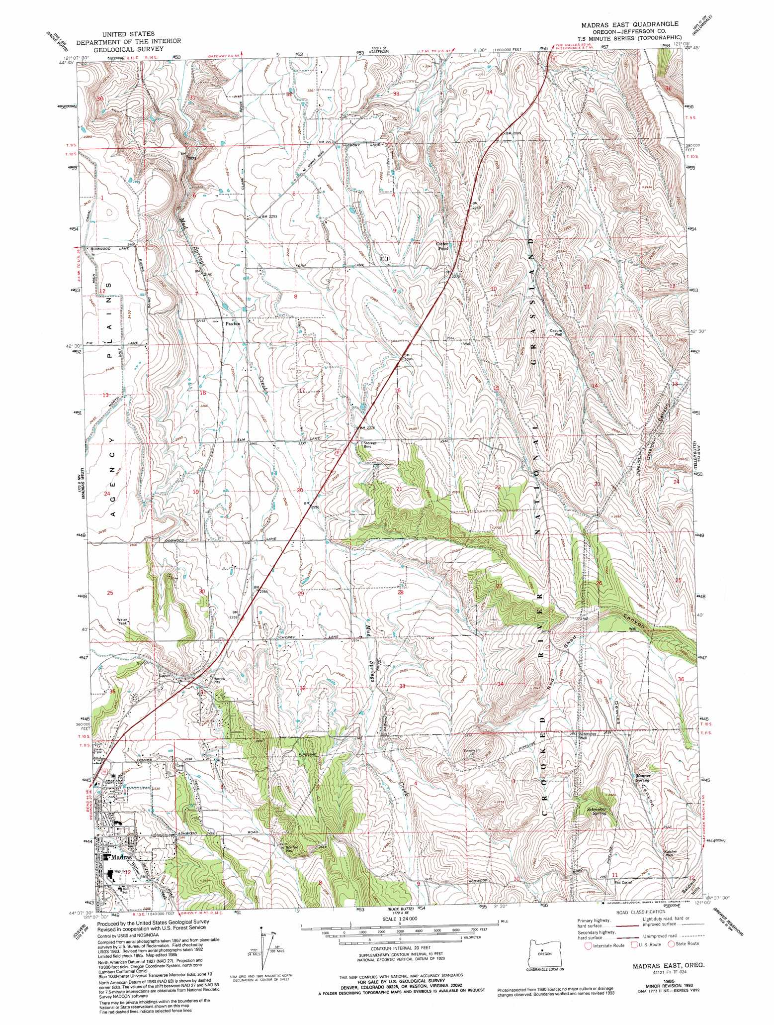
USGS Topo Quad 44121f1 - 1:24,000 scale
| Topo Map Name: | Madras East |
| USGS Topo Quad ID: | 44121f1 |
| Print Size: | ca. 21 1/4" wide x 27" high |
| Southeast Coordinates: | 44.625° N latitude / 121° W longitude |
| Map Center Coordinates: | 44.6875° N latitude / 121.0625° W longitude |
| U.S. State: | OR |
| Filename: | o44121f1.jpg |
| Download Map JPG Image: | Madras East topo map 1:24,000 scale |
| Map Type: | Topographic |
| Topo Series: | 7.5´ |
| Map Scale: | 1:24,000 |
| Source of Map Images: | United States Geological Survey (USGS) |
| Alternate Map Versions: |
Madras East OR 1963, updated 1964 Download PDF Buy paper map Madras East OR 1963, updated 1978 Download PDF Buy paper map Madras East OR 1985, updated 1986 Download PDF Buy paper map Madras East OR 1985, updated 1994 Download PDF Buy paper map Madras East OR 1992, updated 1997 Download PDF Buy paper map Madras East OR 2011 Download PDF Buy paper map Madras East OR 2014 Download PDF Buy paper map |
| FStopo: | US Forest Service topo Madras East is available: Download FStopo PDF Download FStopo TIF |
1:24,000 Topo Quads surrounding Madras East
Simnasho |
Mutton Mountain |
Kaskela |
Shaniko Junction |
Shaniko Summit |
Warm Springs |
Eagle Butte |
Gateway |
Willowdale |
Degner Canyon |
Seekseequa Junction |
Madras West |
Madras East |
Teller Butte |
Ashwood |
Round Butte Dam |
Culver |
Buck Butte |
Brewer Reservoir |
Foley Butte |
Steelhead Falls |
Opal City |
Gray Butte |
Grizzly Mountain |
Hensley Butte |
> Back to 44121e1 at 1:100,000 scale
> Back to 44120a1 at 1:250,000 scale
> Back to U.S. Topo Maps home
Madras East topo map: Gazetteer
Madras East: Parks
Bean Park elevation 703m 2306′Cowden Park elevation 699m 2293′
Juniper Hill Park elevation 727m 2385′
Oak Street Park elevation 700m 2296′
Madras East: Reservoirs
Cotter Pond elevation 690m 2263′Madras East: Springs
Monner Spring elevation 851m 2791′Schmoker Spring elevation 849m 2785′
Madras East: Valleys
Coleman Canyon elevation 709m 2326′Dewies Canyon elevation 799m 2621′
Mud Springs Valley elevation 639m 2096′
Red Shed Canyon elevation 695m 2280′
Madras East: Wells
Coburn Well elevation 693m 2273′Kutcher Well elevation 898m 2946′
Schmoker Well elevation 806m 2644′
Madras East digital topo map on disk
Buy this Madras East topo map showing relief, roads, GPS coordinates and other geographical features, as a high-resolution digital map file on DVD: