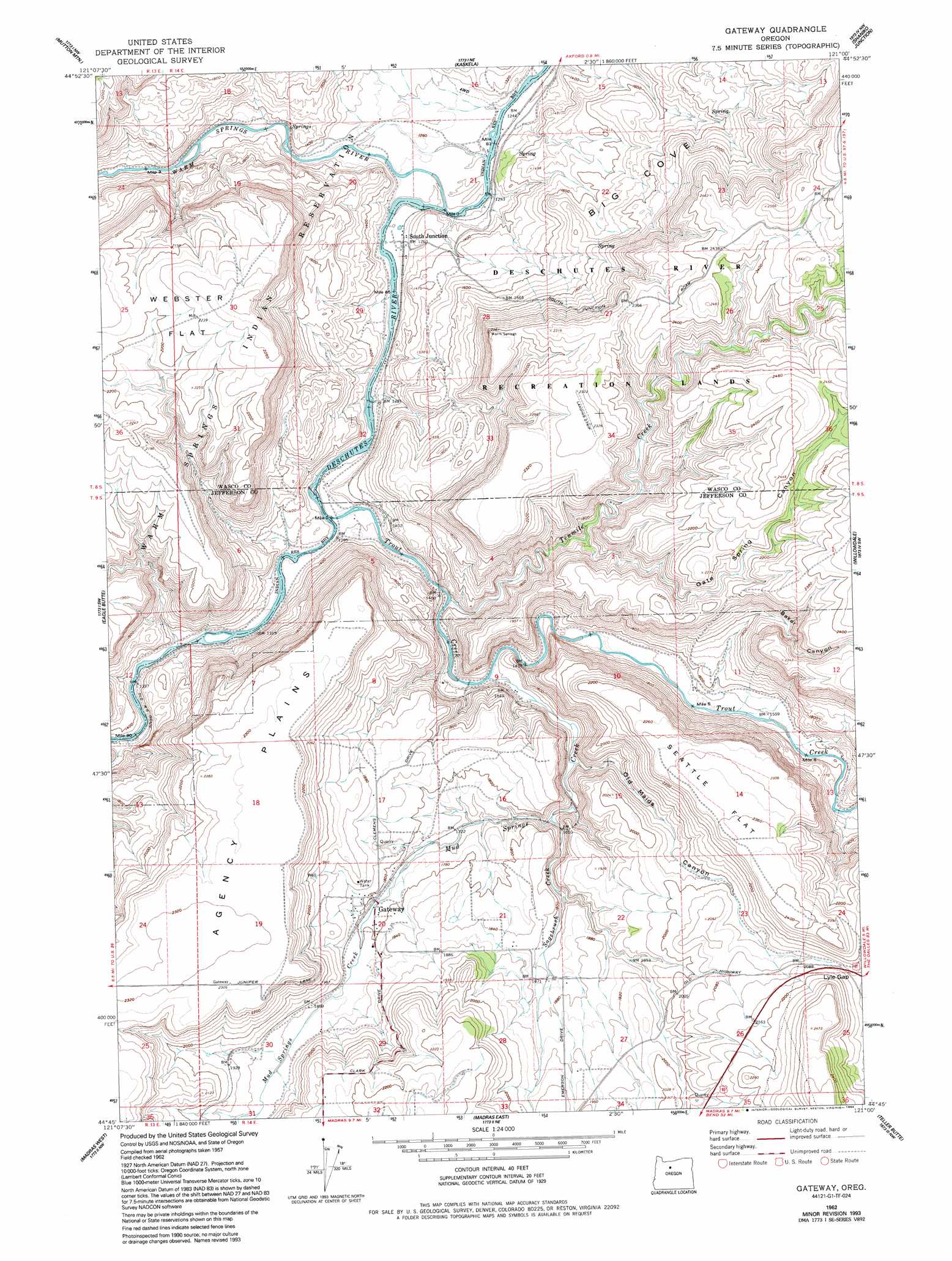
Gateway Topo Map Oregon
To zoom in, hover over the map of Gateway
USGS Topo Quad 44121g1 - 1:24,000 scale
| Topo Map Name: | Gateway |
| USGS Topo Quad ID: | 44121g1 |
| Print Size: | ca. 21 1/4" wide x 27" high |
| Southeast Coordinates: | 44.75° N latitude / 121° W longitude |
| Map Center Coordinates: | 44.8125° N latitude / 121.0625° W longitude |
| U.S. State: | OR |
| Filename: | o44121g1.jpg |
| Download Map JPG Image: | Gateway topo map 1:24,000 scale |
| Map Type: | Topographic |
| Topo Series: | 7.5´ |
| Map Scale: | 1:24,000 |
| Source of Map Images: | United States Geological Survey (USGS) |
| Alternate Map Versions: |
Gateway OR 1962, updated 1964 Download PDF Buy paper map Gateway OR 1962, updated 1980 Download PDF Buy paper map Gateway OR 1962, updated 1992 Download PDF Buy paper map Gateway OR 1962, updated 1994 Download PDF Buy paper map Gateway OR 2011 Download PDF Buy paper map Gateway OR 2014 Download PDF Buy paper map |
1:24,000 Topo Quads surrounding Gateway
Wapinitia |
Maupin Sw |
Dant |
Criterion |
Shaniko |
Simnasho |
Mutton Mountain |
Kaskela |
Shaniko Junction |
Shaniko Summit |
Warm Springs |
Eagle Butte |
Gateway |
Willowdale |
Degner Canyon |
Seekseequa Junction |
Madras West |
Madras East |
Teller Butte |
Ashwood |
Round Butte Dam |
Culver |
Buck Butte |
Brewer Reservoir |
Foley Butte |
> Back to 44121e1 at 1:100,000 scale
> Back to 44120a1 at 1:250,000 scale
> Back to U.S. Topo Maps home
Gateway topo map: Gazetteer
Gateway: Cliffs
Coleman Point elevation 510m 1673′Gateway: Flats
Seattle Flat elevation 717m 2352′Webster Flat elevation 669m 2194′
Gateway: Gaps
Lyle Gap elevation 646m 2119′Gateway: Populated Places
Gateway elevation 547m 1794′Gateway: Post Offices
Gateway Post Office (historical) elevation 547m 1794′South Junction Post Office (historical) elevation 383m 1256′
Youngs Post Office (historical) elevation 517m 1696′
Gateway: Springs
Jersey Spring elevation 422m 1384′Gateway: Streams
Brocher Creek elevation 417m 1368′Mud Springs Creek elevation 434m 1423′
Sagebrush Creek elevation 498m 1633′
Trout Creek elevation 391m 1282′
Warm Springs River elevation 378m 1240′
Gateway: Valleys
Baker Canyon elevation 485m 1591′Frog Springs Canyon elevation 415m 1361′
Gate Spring Canyon elevation 513m 1683′
Old Maids Canyon elevation 534m 1751′
Gateway digital topo map on disk
Buy this Gateway topo map showing relief, roads, GPS coordinates and other geographical features, as a high-resolution digital map file on DVD: