Mount Lowe Topo Map Oregon
To zoom in, hover over the map of Mount Lowe
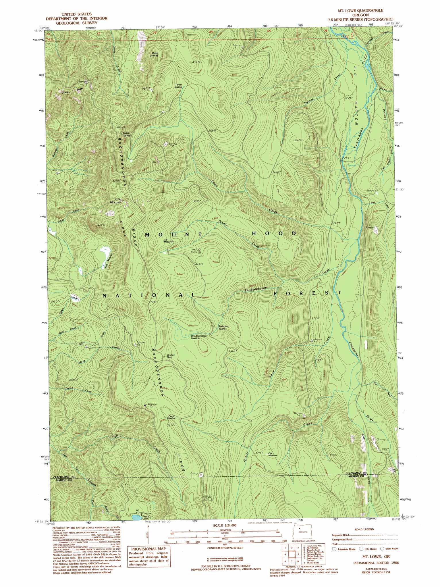
USGS Topo Quad 44121h8 - 1:24,000 scale
| Topo Map Name: | Mount Lowe |
| USGS Topo Quad ID: | 44121h8 |
| Print Size: | ca. 21 1/4" wide x 27" high |
| Southeast Coordinates: | 44.875° N latitude / 121.875° W longitude |
| Map Center Coordinates: | 44.9375° N latitude / 121.9375° W longitude |
| U.S. State: | OR |
| Filename: | o44121h8.jpg |
| Download Map JPG Image: | Mount Lowe topo map 1:24,000 scale |
| Map Type: | Topographic |
| Topo Series: | 7.5´ |
| Map Scale: | 1:24,000 |
| Source of Map Images: | United States Geological Survey (USGS) |
| Alternate Map Versions: |
Mt. Lowe OR 1986, updated 1986 Download PDF Buy paper map Mt. Lowe OR 1986, updated 1994 Download PDF Buy paper map Mount Lowe OR 1997, updated 1999 Download PDF Buy paper map Mount Lowe OR 2011 Download PDF Buy paper map Mount Lowe OR 2014 Download PDF Buy paper map |
| FStopo: | US Forest Service topo Mount Lowe is available: Download FStopo PDF Download FStopo TIF |
1:24,000 Topo Quads surrounding Mount Lowe
Bedford Point |
Three Lynx |
High Rock |
Wolf Peak |
Wapinitia Pass |
Wanderers Peak |
Fish Creek Mountain |
Mount Mitchell |
Timothy Lake |
Mount Wilson |
Bagby Hot Spring |
Bull Of The Woods |
Mount Lowe |
Pinhead Buttes |
Fort Butte |
Battle Ax |
Mother Lode Mountain |
Breitenbush Hot Spring |
Olallie Butte |
Boulder Lake |
Detroit |
Idanha |
Mount Bruno |
Mount Jefferson |
Lionshead |
> Back to 44121e1 at 1:100,000 scale
> Back to 44120a1 at 1:250,000 scale
> Back to U.S. Topo Maps home
Mount Lowe topo map: Gazetteer
Mount Lowe: Flats
Bob Meadow elevation 1181m 3874′Eds Meadow elevation 1146m 3759′
Fawn Meadow elevation 1362m 4468′
Jim Meadow elevation 1315m 4314′
Rhododendron Meadow elevation 1287m 4222′
Mount Lowe: Gaps
Graham Pass elevation 1309m 4294′Mount Lowe: Lakes
Round Lake elevation 1095m 3592′Mount Lowe: Ridges
Rhododendron Ridge elevation 1384m 4540′Mount Lowe: Springs
Fadeaway Spring elevation 1194m 3917′Saddle Springs elevation 1470m 4822′
Tarzan Springs elevation 1276m 4186′
Mount Lowe: Streams
Bonner Creek elevation 682m 2237′Cambell Creek elevation 707m 2319′
Campbell Creek elevation 653m 2142′
Cub Creek elevation 777m 2549′
Fawn Creek elevation 734m 2408′
Hunter Creek elevation 778m 2552′
Kansas Creek elevation 647m 2122′
Last Creek elevation 717m 2352′
Lowe Creek elevation 763m 2503′
Ochre Creek elevation 936m 3070′
Pinhead Creek elevation 672m 2204′
Rhododendron Creek elevation 733m 2404′
Round Creek elevation 834m 2736′
Sisi Creek elevation 777m 2549′
Tumble Creek elevation 885m 2903′
Wall Creek elevation 725m 2378′
Mount Lowe: Summits
Burnt Granite elevation 1516m 4973′Mount Lowe elevation 1599m 5246′
Mount Lowe: Trails
Hunter Camp Way elevation 1241m 4071′Hunter Creek Trail elevation 1171m 3841′
Lowe Creek Trail elevation 1165m 3822′
Rhododendron Ridge Trail elevation 1548m 5078′
Mount Lowe digital topo map on disk
Buy this Mount Lowe topo map showing relief, roads, GPS coordinates and other geographical features, as a high-resolution digital map file on DVD: