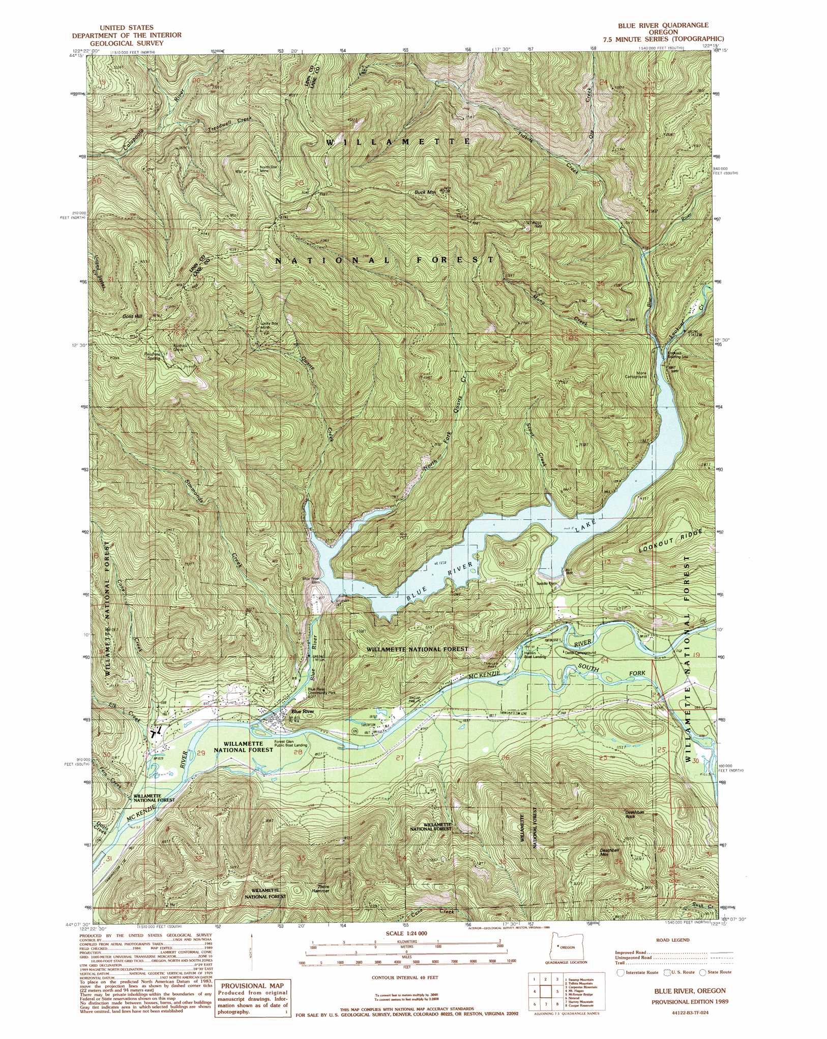
Blue River Topo Map Oregon
To zoom in, hover over the map of Blue River
USGS Topo Quad 44122b3 - 1:24,000 scale
| Topo Map Name: | Blue River |
| USGS Topo Quad ID: | 44122b3 |
| Print Size: | ca. 21 1/4" wide x 27" high |
| Southeast Coordinates: | 44.125° N latitude / 122.25° W longitude |
| Map Center Coordinates: | 44.1875° N latitude / 122.3125° W longitude |
| U.S. State: | OR |
| Filename: | o44122b3.jpg |
| Download Map JPG Image: | Blue River topo map 1:24,000 scale |
| Map Type: | Topographic |
| Topo Series: | 7.5´ |
| Map Scale: | 1:24,000 |
| Source of Map Images: | United States Geological Survey (USGS) |
| Alternate Map Versions: |
Blue River OR 1989, updated 1989 Download PDF Buy paper map Blue River OR 1997, updated 2001 Download PDF Buy paper map Blue River OR 2011 Download PDF Buy paper map Blue River OR 2014 Download PDF Buy paper map |
| FStopo: | US Forest Service topo Blue River is available: Download FStopo PDF Download FStopo TIF |
1:24,000 Topo Quads surrounding Blue River
Green Peter |
Cascadia |
Upper Soda |
Harter Mountain |
Echo Mountain |
Farmers Butte |
Swamp Mountain |
Tidbits Mountain |
Carpenter Mountain |
Tamolitch Falls |
Vida |
Mount Hagan |
Blue River |
Mckenzie Bridge |
Belknap Springs |
Goat Mountain |
Nimrod |
Harvey Mountain |
Cougar Reservoir |
French Mountain |
Saddleblanket Mountain |
Sinker Mountain |
Sardine Butte |
Grasshopper Mountain |
Chucksney Mountain |
> Back to 44122a1 at 1:100,000 scale
> Back to 44122a1 at 1:250,000 scale
> Back to U.S. Topo Maps home
Blue River topo map: Gazetteer
Blue River: Dams
Blue River Dam elevation 408m 1338′Saddle Dam elevation 414m 1358′
Strube Dam elevation 355m 1164′
Blue River: Mines
Cinderella Mine (historical) elevation 1262m 4140′Lucky Boy Mine elevation 969m 3179′
North Star Mine elevation 1233m 4045′
Rialto Mine elevation 1277m 4189′
Blue River: Parks
Blue River Community Park elevation 324m 1062′Forest Glen Landing County Park elevation 323m 1059′
H J Andrews Monument elevation 473m 1551′
McKenzie River Park elevation 322m 1056′
Blue River: Pillars
Deathball Rock elevation 1224m 4015′Blue River: Populated Places
Blue River elevation 318m 1043′Blue River: Post Offices
Blue River Post Office elevation 318m 1043′Luckyboy Post Office (historical) elevation 978m 3208′
Blue River: Reservoirs
Blue River Lake elevation 354m 1161′Strube Lake elevation 366m 1200′
Blue River: Springs
Renfrew Spring elevation 1357m 4452′Blue River: Streams
Blue River elevation 317m 1040′Clapper Creek elevation 316m 1036′
Cone Creek elevation 368m 1207′
Doris Creek elevation 321m 1053′
East Fork Keeney Creek elevation 821m 2693′
Eighteen Creek elevation 683m 2240′
Elk Creek elevation 316m 1036′
Fern Creek elevation 316m 1036′
Keeney Creek elevation 723m 2372′
Lookout Creek elevation 413m 1354′
Mona Creek elevation 417m 1368′
North Fork Quartz Creek elevation 413m 1354′
Ore Creek elevation 519m 1702′
Quartz Creek elevation 359m 1177′
Scout Creek elevation 413m 1354′
Simmonds Creek elevation 325m 1066′
South Fork McKenzie River elevation 330m 1082′
Sparks Creek elevation 318m 1043′
Tidbits Creek elevation 438m 1437′
Treadwell Creek elevation 780m 2559′
West Fork Keeney Creek elevation 821m 2693′
Blue River: Summits
Buck Mountain elevation 1369m 4491′Gold Hill elevation 1320m 4330′
Thors Hammer elevation 997m 3270′
Blue River digital topo map on disk
Buy this Blue River topo map showing relief, roads, GPS coordinates and other geographical features, as a high-resolution digital map file on DVD: