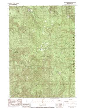
Swamp Mountain Topo Map Oregon
To zoom in, hover over the map of Swamp Mountain
USGS Topo Quad 44122c4 - 1:24,000 scale
| Topo Map Name: | Swamp Mountain |
| USGS Topo Quad ID: | 44122c4 |
| Print Size: | ca. 21 1/4" wide x 27" high |
| Southeast Coordinates: | 44.25° N latitude / 122.375° W longitude |
| Map Center Coordinates: | 44.3125° N latitude / 122.4375° W longitude |
| U.S. State: | OR |
| Filename: | o44122c4.jpg |
| Download Map JPG Image: | Swamp Mountain topo map 1:24,000 scale |
| Map Type: | Topographic |
| Topo Series: | 7.5´ |
| Map Scale: | 1:24,000 |
| Source of Map Images: | United States Geological Survey (USGS) |
| Alternate Map Versions: |
Swamp Mountain OR 1989, updated 1989 Download PDF Buy paper map Swamp Mountain OR 1997, updated 2001 Download PDF Buy paper map Swamp Mountain OR 2011 Download PDF Buy paper map Swamp Mountain OR 2014 Download PDF Buy paper map |
| FStopo: | US Forest Service topo Swamp Mountain is available: Download FStopo PDF Download FStopo TIF |
1:24,000 Topo Quads surrounding Swamp Mountain
> Back to 44122a1 at 1:100,000 scale
> Back to 44122a1 at 1:250,000 scale
> Back to U.S. Topo Maps home
Swamp Mountain topo map: Gazetteer
Swamp Mountain: Ridges
Green Mountain Ridge elevation 1367m 4484′Swamp Mountain: Streams
Black Creek elevation 398m 1305′Flimflam Creek elevation 410m 1345′
Swamp Mountain: Summits
Swamp Mountain elevation 1321m 4333′Swamp Mountain digital topo map on disk
Buy this Swamp Mountain topo map showing relief, roads, GPS coordinates and other geographical features, as a high-resolution digital map file on DVD:


