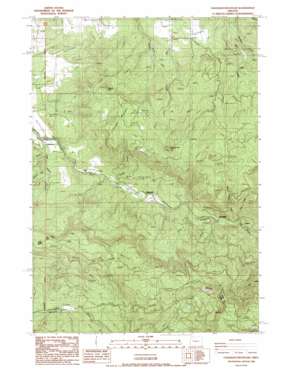
Chandler Mountain Topo Map Oregon
To zoom in, hover over the map of Chandler Mountain
USGS Topo Quad 44122c6 - 1:24,000 scale
| Topo Map Name: | Chandler Mountain |
| USGS Topo Quad ID: | 44122c6 |
| Print Size: | ca. 21 1/4" wide x 27" high |
| Southeast Coordinates: | 44.25° N latitude / 122.625° W longitude |
| Map Center Coordinates: | 44.3125° N latitude / 122.6875° W longitude |
| U.S. State: | OR |
| Filename: | o44122c6.jpg |
| Download Map JPG Image: | Chandler Mountain topo map 1:24,000 scale |
| Map Type: | Topographic |
| Topo Series: | 7.5´ |
| Map Scale: | 1:24,000 |
| Source of Map Images: | United States Geological Survey (USGS) |
| Alternate Map Versions: |
Chandler Mountain OR 1988, updated 1988 Download PDF Buy paper map Chandler Mountain OR 2011 Download PDF Buy paper map Chandler Mountain OR 2014 Download PDF Buy paper map |
1:24,000 Topo Quads surrounding Chandler Mountain
> Back to 44122a1 at 1:100,000 scale
> Back to 44122a1 at 1:250,000 scale
> Back to U.S. Topo Maps home
Chandler Mountain topo map: Gazetteer
Chandler Mountain: Pillars
Chimney Rock elevation 736m 2414′Chandler Mountain: Populated Places
Calapooia elevation 187m 613′Chandler Mountain: Reservoirs
Browns Reservoir elevation 279m 915′Chandler Mountain: Streams
Carrie Fork elevation 242m 793′Cedar Creek elevation 219m 718′
Fox Creek elevation 261m 856′
Pugh Creek elevation 189m 620′
Sweet Home Creek elevation 262m 859′
Chandler Mountain: Summits
Cassnor Park elevation 627m 2057′Chandler Mountain elevation 637m 2089′
Chandler Mountain digital topo map on disk
Buy this Chandler Mountain topo map showing relief, roads, GPS coordinates and other geographical features, as a high-resolution digital map file on DVD:


