Stayton Ne Topo Map Oregon
To zoom in, hover over the map of Stayton Ne
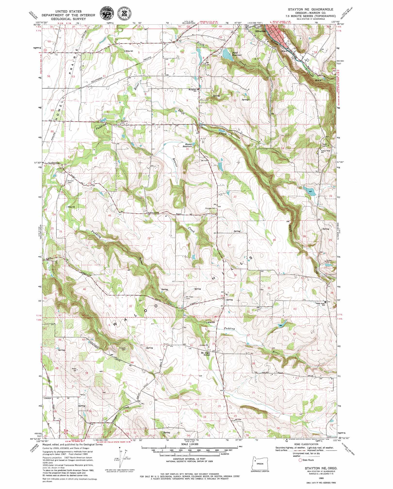
USGS Topo Quad 44122h7 - 1:24,000 scale
| Topo Map Name: | Stayton Ne |
| USGS Topo Quad ID: | 44122h7 |
| Print Size: | ca. 21 1/4" wide x 27" high |
| Southeast Coordinates: | 44.875° N latitude / 122.75° W longitude |
| Map Center Coordinates: | 44.9375° N latitude / 122.8125° W longitude |
| U.S. State: | OR |
| Filename: | o44122h7.jpg |
| Download Map JPG Image: | Stayton Ne topo map 1:24,000 scale |
| Map Type: | Topographic |
| Topo Series: | 7.5´ |
| Map Scale: | 1:24,000 |
| Source of Map Images: | United States Geological Survey (USGS) |
| Alternate Map Versions: |
Stayton NE OR 1969, updated 1971 Download PDF Buy paper map Stayton NE OR 1969, updated 1979 Download PDF Buy paper map Stayton NE OR 2011 Download PDF Buy paper map Stayton NE OR 2014 Download PDF Buy paper map |
1:24,000 Topo Quads surrounding Stayton Ne
Dayton |
Saint Paul |
Woodburn |
Yoder |
Molalla |
Mission Bottom |
Gervais |
Silverton |
Scotts Mills |
Wilhoit |
Salem West |
Salem East |
Stayton Ne |
Drake Crossing |
Elk Prairie |
Sidney |
Turner |
Stayton |
Stout Mountain |
Lyons |
Albany |
Crabtree |
Scio |
Jordan |
Snow Peak |
> Back to 44122e1 at 1:100,000 scale
> Back to 44122a1 at 1:250,000 scale
> Back to U.S. Topo Maps home
Stayton Ne topo map: Gazetteer
Stayton Ne: Dams
Barnes Brothers Reservoir Dam elevation 133m 436′Funrue Dam elevation 202m 662′
Lorence Dam elevation 202m 662′
Pettit Dam elevation 65m 213′
S M S Dam Number 1 elevation 200m 656′
Stayton Ne: Flats
Howell Prairie elevation 58m 190′Stayton Ne: Parks
Rogers Wayside County Park elevation 66m 216′Stayton Ne: Populated Places
Clymer (historical) elevation 193m 633′Willard (historical) elevation 171m 561′
Stayton Ne: Post Offices
Clymer Post Office (historical) elevation 193m 633′Lebanon Post Office (historical) elevation 161m 528′
Silver Creek Post Office (historical) elevation 99m 324′
Switzerland Post Office (historical) elevation 69m 226′
Willard Post Office (historical) elevation 171m 561′
Stayton Ne: Reservoirs
Barnes Brothers Reservoir elevation 133m 436′Barnes Reservoir elevation 130m 426′
Beaver Creek Reservoir elevation 53m 173′
Bye Reservoir elevation 61m 200′
Campbell Reservoir elevation 110m 360′
Funrue Reservoir elevation 202m 662′
Grier Reservoir elevation 168m 551′
Kuenzi Reservoir elevation 80m 262′
Lorence Reservoir elevation 202m 662′
Pettit Reservoir elevation 65m 213′
Quigley Reservoir elevation 197m 646′
S M S Reservoir Number One elevation 200m 656′
Schmid Reservoir elevation 71m 232′
Spady Reservoir elevation 62m 203′
Stadeli Reservoir elevation 58m 190′
Urban Reservoir elevation 75m 246′
Valley View Reservoir elevation 216m 708′
Wright Sump elevation 51m 167′
Stayton Ne: Streams
Beaver Creek elevation 48m 157′Drift Creek elevation 50m 164′
South Fork Pudding River elevation 55m 180′
Stayton Ne: Summits
Waldo Hills elevation 225m 738′Stayton Ne digital topo map on disk
Buy this Stayton Ne topo map showing relief, roads, GPS coordinates and other geographical features, as a high-resolution digital map file on DVD: