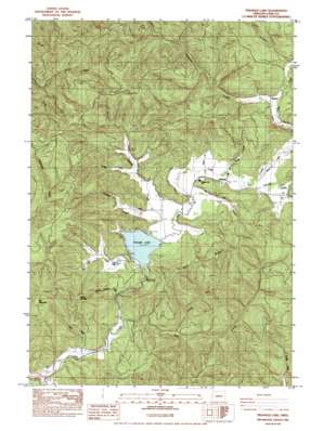
Triangle Lake Topo Map Oregon
To zoom in, hover over the map of Triangle Lake
USGS Topo Quad 44123b5 - 1:24,000 scale
| Topo Map Name: | Triangle Lake |
| USGS Topo Quad ID: | 44123b5 |
| Print Size: | ca. 21 1/4" wide x 27" high |
| Southeast Coordinates: | 44.125° N latitude / 123.5° W longitude |
| Map Center Coordinates: | 44.1875° N latitude / 123.5625° W longitude |
| U.S. State: | OR |
| Filename: | o44123b5.jpg |
| Download Map JPG Image: | Triangle Lake topo map 1:24,000 scale |
| Map Type: | Topographic |
| Topo Series: | 7.5´ |
| Map Scale: | 1:24,000 |
| Source of Map Images: | United States Geological Survey (USGS) |
| Alternate Map Versions: |
Triangle Lake OR 1984, updated 1984 Download PDF Buy paper map Triangle Lake OR 2011 Download PDF Buy paper map Triangle Lake OR 2014 Download PDF Buy paper map |
1:24,000 Topo Quads surrounding Triangle Lake
> Back to 44123a1 at 1:100,000 scale
> Back to 44122a1 at 1:250,000 scale
> Back to U.S. Topo Maps home
Triangle Lake topo map: Gazetteer
Triangle Lake: Lakes
Little Lake elevation 214m 702′Triangle Lake elevation 207m 679′
Triangle Lake: Parks
Lake Creek Recreation Area elevation 144m 472′Triangle Lake County Park elevation 217m 711′
Triangle Lake: Populated Places
Blachly elevation 220m 721′Triangle Lake elevation 211m 692′
Triangle Lake: Post Offices
Blachly Post Office elevation 220m 721′Triangle Lake: Reservoirs
John Griffith Reservoir elevation 218m 715′Triangle Lake: Ridges
Bear Ridge elevation 469m 1538′Triangle Lake: Springs
Little Lake Spring elevation 334m 1095′Triangle Lake: Streams
Congdon Creek elevation 223m 731′Conrad Creek elevation 218m 715′
Druggs Creek elevation 221m 725′
Fish Creek elevation 129m 423′
Greenleaf Creek elevation 117m 383′
Lamb Creek elevation 123m 403′
Little Lake Creek elevation 215m 705′
North Fork Fish Creek elevation 176m 577′
Pontius Creek elevation 214m 702′
Pope Creek elevation 216m 708′
Post Creek elevation 212m 695′
Pucker Creek elevation 228m 748′
South Fork Lobster Creek elevation 326m 1069′
Spring Canyon Creek elevation 165m 541′
Swamp Creek elevation 210m 688′
Triangle Lake: Summits
Elk Mountain elevation 701m 2299′Little Elk Mountain elevation 422m 1384′
Triangle Lake digital topo map on disk
Buy this Triangle Lake topo map showing relief, roads, GPS coordinates and other geographical features, as a high-resolution digital map file on DVD:


