Flat Mountain Topo Map Oregon
To zoom in, hover over the map of Flat Mountain
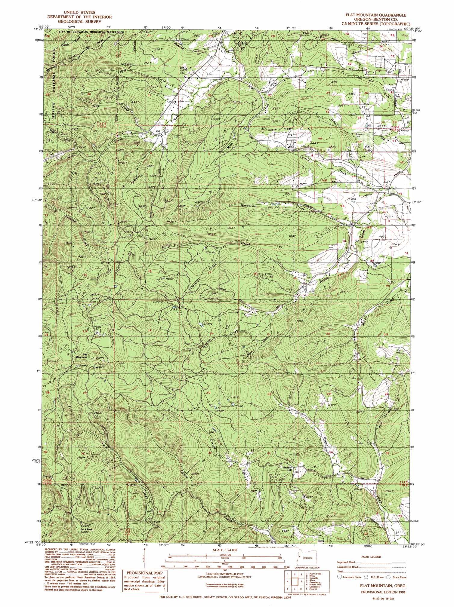
USGS Topo Quad 44123d4 - 1:24,000 scale
| Topo Map Name: | Flat Mountain |
| USGS Topo Quad ID: | 44123d4 |
| Print Size: | ca. 21 1/4" wide x 27" high |
| Southeast Coordinates: | 44.375° N latitude / 123.375° W longitude |
| Map Center Coordinates: | 44.4375° N latitude / 123.4375° W longitude |
| U.S. State: | OR |
| Filename: | o44123d4.jpg |
| Download Map JPG Image: | Flat Mountain topo map 1:24,000 scale |
| Map Type: | Topographic |
| Topo Series: | 7.5´ |
| Map Scale: | 1:24,000 |
| Source of Map Images: | United States Geological Survey (USGS) |
| Alternate Map Versions: |
Flat Mountain OR 1984, updated 1984 Download PDF Buy paper map Flat Mountain OR 2011 Download PDF Buy paper map Flat Mountain OR 2014 Download PDF Buy paper map |
| FStopo: | US Forest Service topo Flat Mountain is available: Download FStopo PDF Download FStopo TIF |
1:24,000 Topo Quads surrounding Flat Mountain
Nortons |
Summit |
Kings Valley |
Airlie South |
Lewisburg |
Harlan |
Marys Peak |
Wren |
Corvallis |
Riverside |
Grass Mountain |
Alsea |
Flat Mountain |
Greenberry |
Peoria |
Digger Mountain |
Prairie Peak |
Glenbrook |
Monroe |
Harrisburg |
Windy Peak |
Triangle Lake |
Horton |
Cheshire |
Junction City |
> Back to 44123a1 at 1:100,000 scale
> Back to 44122a1 at 1:250,000 scale
> Back to U.S. Topo Maps home
Flat Mountain topo map: Gazetteer
Flat Mountain: Ridges
Decker Ridge elevation 212m 695′Franklin Ridge elevation 475m 1558′
Flat Mountain: Streams
Cedar Creek elevation 143m 469′Cheyenne Creek elevation 176m 577′
Dinner Creek elevation 268m 879′
Duffy Creek elevation 121m 396′
Ervin Creek elevation 131m 429′
Gleason Creek elevation 155m 508′
Henderson Creek elevation 97m 318′
Hyde Creek elevation 123m 403′
Kiser Creek elevation 317m 1040′
Mercer Creek elevation 91m 298′
Moss Creek elevation 115m 377′
Powell Creek elevation 87m 285′
Rickard Creek elevation 186m 610′
Ridenour Creek elevation 110m 360′
South Creek elevation 155m 508′
Spencer Creek elevation 127m 416′
Wells Creek elevation 141m 462′
Westwood Creek elevation 111m 364′
Flat Mountain: Summits
Buck Peak elevation 643m 2109′Bunker Hill elevation 247m 810′
Flat Mountain elevation 810m 2657′
Flat Mountain: Valleys
Hells Canyon elevation 154m 505′Flat Mountain digital topo map on disk
Buy this Flat Mountain topo map showing relief, roads, GPS coordinates and other geographical features, as a high-resolution digital map file on DVD: