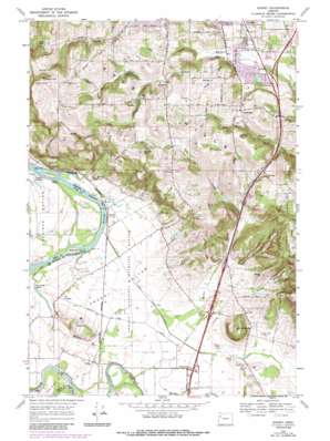
Sidney Topo Map Oregon
To zoom in, hover over the map of Sidney
USGS Topo Quad 44123g1 - 1:24,000 scale
| Topo Map Name: | Sidney |
| USGS Topo Quad ID: | 44123g1 |
| Print Size: | ca. 21 1/4" wide x 27" high |
| Southeast Coordinates: | 44.75° N latitude / 123° W longitude |
| Map Center Coordinates: | 44.8125° N latitude / 123.0625° W longitude |
| U.S. State: | OR |
| Filename: | o44123g1.jpg |
| Download Map JPG Image: | Sidney topo map 1:24,000 scale |
| Map Type: | Topographic |
| Topo Series: | 7.5´ |
| Map Scale: | 1:24,000 |
| Source of Map Images: | United States Geological Survey (USGS) |
| Alternate Map Versions: |
Sidney OR 1970, updated 1972 Download PDF Buy paper map Sidney OR 1970, updated 1987 Download PDF Buy paper map Sidney OR 1970, updated 1987 Download PDF Buy paper map Sidney OR 2011 Download PDF Buy paper map Sidney OR 2014 Download PDF Buy paper map |
1:24,000 Topo Quads surrounding Sidney
> Back to 44123e1 at 1:100,000 scale
> Back to 44122a1 at 1:250,000 scale
> Back to U.S. Topo Maps home
Sidney topo map: Gazetteer
Sidney: Airports
Art Brandt Airport elevation 70m 229′Gilmore Ag Air elevation 63m 206′
Morlan Airfield elevation 52m 170′
Wagoner Airfield elevation 215m 705′
Sidney: Bars
Judson Rocks elevation 47m 154′Whiteman Bar elevation 48m 157′
Sidney: Canals
Sidney Power Ditch elevation 61m 200′Sidney: Dams
Ornoname 10 Dam elevation 109m 357′River Bend Dam elevation 62m 203′
Spring Lake Dam elevation 102m 334′
Sidney: Flats
American Bottom elevation 51m 167′Ankeny Bottom elevation 60m 196′
Sidney: Islands
Cole Island elevation 57m 187′Sidney: Lakes
Keesneck Lake elevation 50m 164′Sidney: Parks
Ankeny National Wildlife Refuge elevation 61m 200′Joryville County Park elevation 208m 682′
Lee School Park elevation 130m 426′
Rees City Park elevation 130m 426′
Wild Fawn Park elevation 195m 639′
Sidney: Populated Places
Dencer (historical) elevation 201m 659′Rosedale elevation 175m 574′
Sidney elevation 59m 193′
Sunnyside elevation 188m 616′
Talbot elevation 58m 190′
Sidney: Post Offices
Dencer Post Office (historical) elevation 201m 659′Lightner Post Office (historical) elevation 229m 751′
Rosedale Post Office (historical) elevation 175m 574′
Sidney Post Office (historical) elevation 59m 193′
Talbot Post Office (historical) elevation 58m 190′
Sidney: Ranges
Salem Hills elevation 252m 826′Sidney: Reservoirs
Eoff Reservoir elevation 109m 357′River Bend Reservoir Number Two elevation 62m 203′
Spring Reservoir elevation 93m 305′
Sidney: Ridges
Ankeny Hill elevation 237m 777′Jory Hill elevation 217m 711′
Sidney: Springs
Crystal Spring elevation 193m 633′Sidney: Streams
Bashaw Creek elevation 50m 164′Chehulpum Creek elevation 59m 193′
Jory Creek elevation 126m 413′
Miller Creek elevation 62m 203′
Neil Creek elevation 94m 308′
Porter Slough elevation 53m 173′
Powell Creek elevation 120m 393′
Rock Creek elevation 48m 157′
Waln Creek elevation 120m 393′
Wilkerson Creek elevation 46m 150′
Sidney: Summits
Barnett Knoll elevation 292m 958′Bunker Hill elevation 291m 954′
Jackson Hill elevation 236m 774′
Looney Butte elevation 176m 577′
Prospect Hill elevation 344m 1128′
Reese Hill elevation 200m 656′
Roby Hill elevation 108m 354′
Steiwer Hill elevation 160m 524′
Twin Hills elevation 212m 695′
Sidney: Valleys
Creswell Canyon elevation 82m 269′Weaver Gulch elevation 73m 239′
Sidney digital topo map on disk
Buy this Sidney topo map showing relief, roads, GPS coordinates and other geographical features, as a high-resolution digital map file on DVD:


