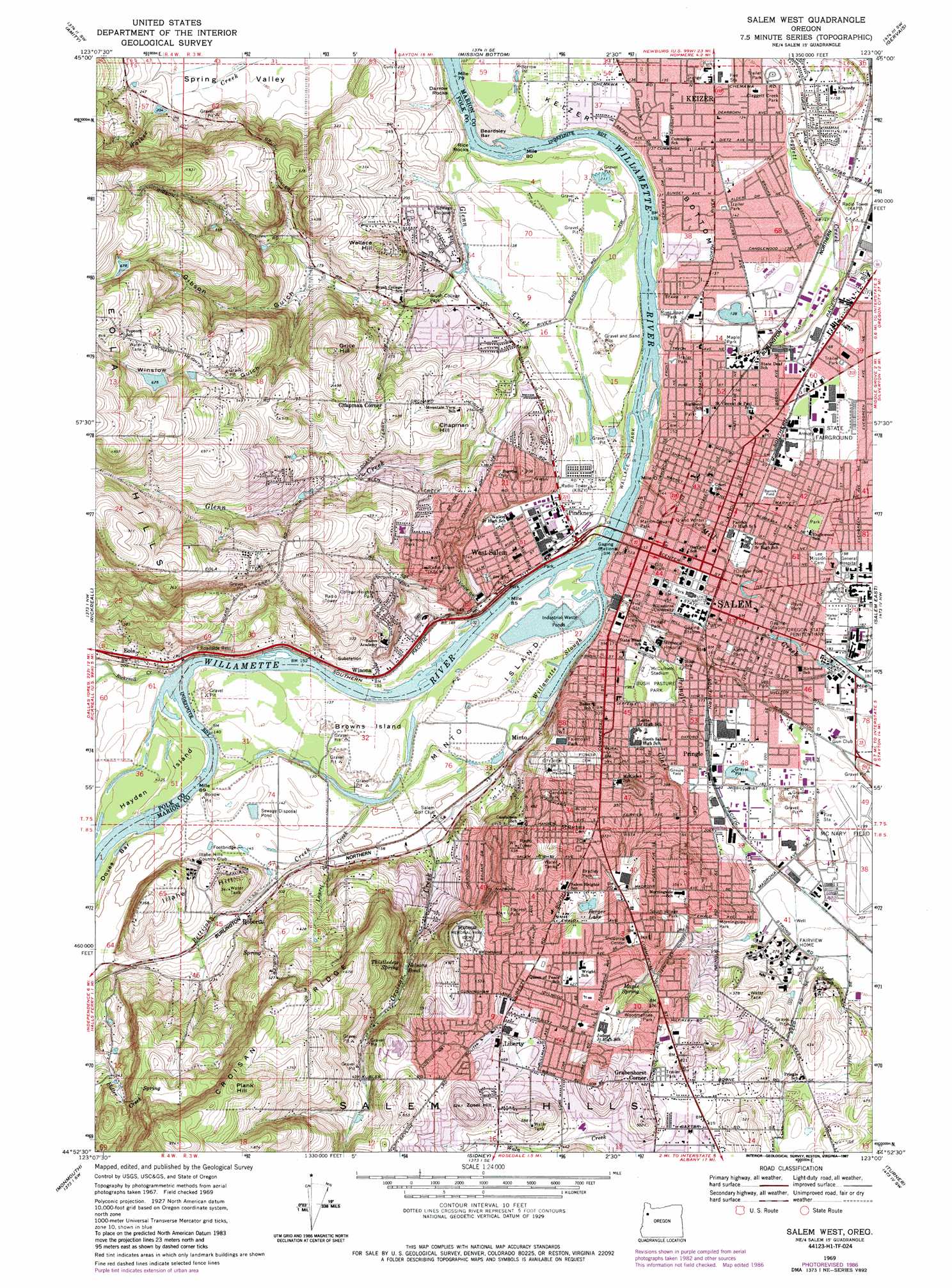
Salem West Topo Map Oregon
To zoom in, hover over the map of Salem West
USGS Topo Quad 44123h1 - 1:24,000 scale
| Topo Map Name: | Salem West |
| USGS Topo Quad ID: | 44123h1 |
| Print Size: | ca. 21 1/4" wide x 27" high |
| Southeast Coordinates: | 44.875° N latitude / 123° W longitude |
| Map Center Coordinates: | 44.9375° N latitude / 123.0625° W longitude |
| U.S. State: | OR |
| Filename: | o44123h1.jpg |
| Download Map JPG Image: | Salem West topo map 1:24,000 scale |
| Map Type: | Topographic |
| Topo Series: | 7.5´ |
| Map Scale: | 1:24,000 |
| Source of Map Images: | United States Geological Survey (USGS) |
| Alternate Map Versions: |
Salem West OR 1969, updated 1972 Download PDF Buy paper map Salem West OR 1969, updated 1980 Download PDF Buy paper map Salem West OR 1969, updated 1987 Download PDF Buy paper map Salem West OR 1969, updated 1987 Download PDF Buy paper map Salem West OR 1969, updated 2001 Download PDF Buy paper map Salem West OR 1975, updated 1980 Download PDF Buy paper map Salem West OR 2011 Download PDF Buy paper map Salem West OR 2014 Download PDF Buy paper map |
1:24,000 Topo Quads surrounding Salem West
Muddy Valley |
Mcminnville |
Dayton |
Saint Paul |
Woodburn |
Ballston |
Amity |
Mission Bottom |
Gervais |
Silverton |
Dallas |
Rickreall |
Salem West |
Salem East |
Stayton Ne |
Airlie North |
Monmouth |
Sidney |
Turner |
Stayton |
Airlie South |
Lewisburg |
Albany |
Crabtree |
Scio |
> Back to 44123e1 at 1:100,000 scale
> Back to 44122a1 at 1:250,000 scale
> Back to U.S. Topo Maps home
Salem West topo map: Gazetteer
Salem West: Airports
Capitol Mall Heliport elevation 51m 167′McNary Field elevation 63m 206′
Mount Jefferson Lumber Company Airstrip elevation 61m 200′
Salem General Unit Hospital Heliport elevation 59m 193′
Salem West: Bars
Beardsley Bar elevation 35m 114′Darrow Rocks elevation 33m 108′
Doves Bar elevation 41m 134′
Gray Eagle Bar elevation 39m 127′
Salem West: Bends
Keizer Bottom elevation 44m 144′Salem West: Canals
Mission Ditch elevation 56m 183′Shelton Ditch elevation 56m 183′
Salem West: Dams
Croft Dam elevation 196m 643′Oak Crest Farm Dam elevation 48m 157′
Ornoname 21 Dam elevation 55m 180′
Salem West: Islands
Browns Island elevation 42m 137′Hayden Island elevation 41m 134′
McLain Island elevation 38m 124′
Minto Island elevation 44m 144′
Rice Rocks elevation 34m 111′
Salem West: Lakes
Stone Quarry Lake elevation 52m 170′Salem West: Parks
Aldrich City Park elevation 53m 173′Barrick Field City Park elevation 52m 170′
Brush College City Park elevation 46m 150′
Bush's Pasture City Park elevation 51m 167′
Candalaria Park elevation 136m 446′
Claggett Creek Park elevation 41m 134′
Clark Creek City Park elevation 78m 255′
Clarmount Park elevation 114m 374′
College Heights City Park elevation 86m 282′
D and Winter Park elevation 47m 154′
Englewood City Park elevation 59m 193′
Eola Bend County Park elevation 43m 141′
Eola Heights County Park elevation 190m 623′
Fairmont City Park elevation 104m 341′
Fircrest City Park elevation 154m 505′
Gilmore Field City Park elevation 57m 187′
Gracemont City Park elevation 97m 318′
Grant City Park elevation 49m 160′
Highland City Park elevation 47m 154′
Highland School City Park elevation 47m 154′
Hillview City Park elevation 123m 403′
Holman State Park elevation 70m 229′
Lee City Park elevation 54m 177′
Maple Park elevation 43m 141′
Marion Square City Park elevation 48m 157′
McCullock Stadium elevation 51m 167′
McKinley School City Park elevation 94m 308′
McRae City Park elevation 56m 183′
Minto-Browns Island City Park elevation 41m 134′
Morningside City Park elevation 87m 285′
Nelson City Park elevation 74m 242′
Olinger Pool Park elevation 50m 164′
Orchard Heights City Park elevation 53m 173′
Oregon State Fairgrounds elevation 52m 170′
Pringle City Park elevation 44m 144′
Richmond School City Park elevation 56m 183′
River Road City Park elevation 43m 141′
Riverfront City Park elevation 47m 154′
South Village City Park elevation 105m 344′
Sprague School/Skyline Park elevation 165m 541′
Straub Nature Park Park elevation 86m 282′
Sumpter School City Park elevation 134m 439′
Sunnyslope City Park elevation 164m 538′
Waldo Park elevation 51m 167′
Walker Park elevation 57m 187′
Wallace Marine City Park elevation 36m 118′
Wendy Kroger City Park elevation 137m 449′
Wes Bennett City Park elevation 128m 419′
West Salem City Park elevation 84m 275′
Wilson Park elevation 50m 164′
Woodmansee City Park elevation 114m 374′
Salem West: Populated Places
Brush College elevation 55m 180′Chapman Corner elevation 113m 370′
Eola elevation 70m 229′
Grabenhorst Corner elevation 129m 423′
Highland Station (historical) elevation 48m 157′
Keizer elevation 42m 137′
Kingwood Park (historical) elevation 56m 183′
Liberty elevation 139m 456′
Salem elevation 49m 160′
Salem Station (historical) elevation 47m 154′
Salemtowne elevation 68m 223′
West Salem elevation 48m 157′
Salem West: Post Offices
Downtown Post Office (historical) elevation 49m 160′Eola Post Office (historical) elevation 72m 236′
Fair Ground Post Office (historical) elevation 52m 170′
Fairgrounds Post Office (historical) elevation 51m 167′
Hollywood Post Office elevation 50m 164′
Hospital Post Office (historical) elevation 64m 209′
Keizer Post Office elevation 42m 137′
Kingwood Post Office (historical) elevation 49m 160′
Liberty Post Office (historical) elevation 139m 456′
Minto Post Office (historical) elevation 49m 160′
Pringle Park Plaza Post Office elevation 56m 183′
South 99E Post Office (historical) elevation 108m 354′
Vista Post Office elevation 105m 344′
West Salem Post Office elevation 48m 157′
Salem West: Rapids
Keizer Rapids elevation 35m 114′Salem West: Reservoirs
Berger Lake elevation 98m 321′Croft Reservoir elevation 196m 643′
Gibson Reservoir elevation 208m 682′
Haines Reservoir elevation 168m 551′
Nelsons Pond elevation 80m 262′
Oak Crest Farm Reservoir elevation 48m 157′
Riverbed Pond elevation 41m 134′
Sexton Reservoir elevation 186m 610′
Staats Reservoir elevation 188m 616′
Salem West: Ridges
Croisan Ridge elevation 235m 770′Salem West: Springs
Fidler Springs elevation 179m 587′Maple Spring elevation 101m 331′
Thistledew Spring elevation 87m 285′
Salem West: Streams
Brush College Creek elevation 56m 183′Chatnicka Creek elevation 82m 269′
Clark Creek elevation 40m 131′
Croisan Creek elevation 41m 134′
Glenn Creek elevation 34m 111′
Hayden Slough elevation 38m 124′
Higgins Creek elevation 175m 574′
Laurel Creek elevation 38m 124′
Mill Creek elevation 37m 121′
Pettijohn Creek elevation 35m 114′
Pringle Creek elevation 40m 131′
Rickreall Creek elevation 41m 134′
Willamette Slough elevation 36m 118′
Salem West: Summits
Chapman Hill elevation 122m 400′Grice Hill elevation 170m 557′
Illahe Hill elevation 74m 242′
Plank Hill elevation 275m 902′
Wallace Hill elevation 130m 426′
Zosel Hill elevation 191m 626′
Salem West: Valleys
Gibson Gulch elevation 48m 157′Winslow Gulch elevation 62m 203′
Salem West digital topo map on disk
Buy this Salem West topo map showing relief, roads, GPS coordinates and other geographical features, as a high-resolution digital map file on DVD: