Rickreall Topo Map Oregon
To zoom in, hover over the map of Rickreall
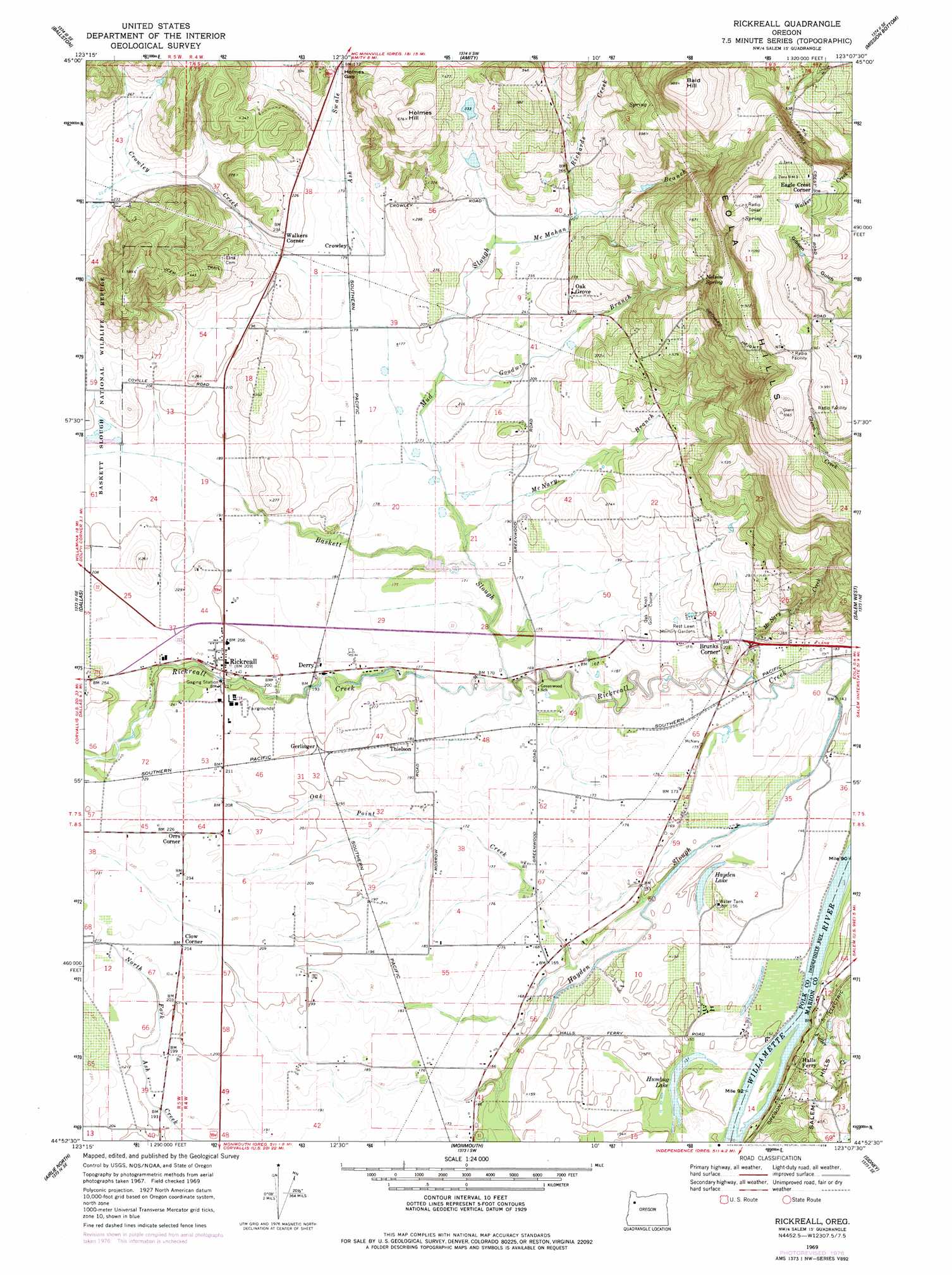
USGS Topo Quad 44123h2 - 1:24,000 scale
| Topo Map Name: | Rickreall |
| USGS Topo Quad ID: | 44123h2 |
| Print Size: | ca. 21 1/4" wide x 27" high |
| Southeast Coordinates: | 44.875° N latitude / 123.125° W longitude |
| Map Center Coordinates: | 44.9375° N latitude / 123.1875° W longitude |
| U.S. State: | OR |
| Filename: | o44123h2.jpg |
| Download Map JPG Image: | Rickreall topo map 1:24,000 scale |
| Map Type: | Topographic |
| Topo Series: | 7.5´ |
| Map Scale: | 1:24,000 |
| Source of Map Images: | United States Geological Survey (USGS) |
| Alternate Map Versions: |
Rickreall OR 1969, updated 1971 Download PDF Buy paper map Rickreall OR 1969, updated 1978 Download PDF Buy paper map Rickreall OR 2011 Download PDF Buy paper map Rickreall OR 2014 Download PDF Buy paper map |
1:24,000 Topo Quads surrounding Rickreall
Stony Mountain |
Muddy Valley |
Mcminnville |
Dayton |
Saint Paul |
Sheridan |
Ballston |
Amity |
Mission Bottom |
Gervais |
Socialist Valley |
Dallas |
Rickreall |
Salem West |
Salem East |
Falls City |
Airlie North |
Monmouth |
Sidney |
Turner |
Kings Valley |
Airlie South |
Lewisburg |
Albany |
Crabtree |
> Back to 44123e1 at 1:100,000 scale
> Back to 44122a1 at 1:250,000 scale
> Back to U.S. Topo Maps home
Rickreall topo map: Gazetteer
Rickreall: Airports
Cascade Airstrip elevation 66m 216′Steel Systems Airstrip elevation 60m 196′
Rickreall: Dams
Marx Dam elevation 111m 364′Rickreall: Gaps
Holmes Gap elevation 53m 173′Rickreall: Lakes
Hayden Lake elevation 39m 127′Humbug Lake elevation 41m 134′
Rickreall: Parks
Nesmith County Park elevation 65m 213′Social Security Hole elevation 47m 154′
Rickreall: Populated Places
Cochrane (historical) elevation 61m 200′Rickreall elevation 65m 213′
Rickreall: Post Offices
Croston Post Office (historical) elevation 56m 183′Crowley Post Office (historical) elevation 56m 183′
Etna Post Office (historical) elevation 66m 216′
Rickreall Post Office elevation 65m 213′
Rickreall: Reservoirs
Beyers Pond elevation 54m 177′Boeder Pond elevation 70m 229′
Eagle Crest Reservoir elevation 265m 869′
Marx Reservoir elevation 111m 364′
Myers Reservoir elevation 46m 150′
Parks Lake Reservoir elevation 54m 177′
Ross Reservoir elevation 78m 255′
Stevens Reservoir elevation 84m 275′
Rickreall: Springs
Eagle Crest Spring elevation 169m 554′Nelson Spring elevation 189m 620′
Rickreall: Streams
Baskett Slough elevation 47m 154′Crowley Creek elevation 53m 173′
Fidler Creek elevation 41m 134′
Goodwin Branch Mud Slough elevation 56m 183′
Harland Slough elevation 59m 193′
McMahan Branch elevation 63m 206′
McNary Branch elevation 50m 164′
McNary Creek elevation 44m 144′
Mineral Creek elevation 41m 134′
Mineral Creek elevation 41m 134′
Mud Slough elevation 50m 164′
Oak Point Creek elevation 38m 124′
Richards Creek elevation 69m 226′
Rickreall: Summits
Bald Hill elevation 301m 987′Holmes Hill elevation 176m 577′
Rickreall digital topo map on disk
Buy this Rickreall topo map showing relief, roads, GPS coordinates and other geographical features, as a high-resolution digital map file on DVD: