Socialist Valley Topo Map Oregon
To zoom in, hover over the map of Socialist Valley
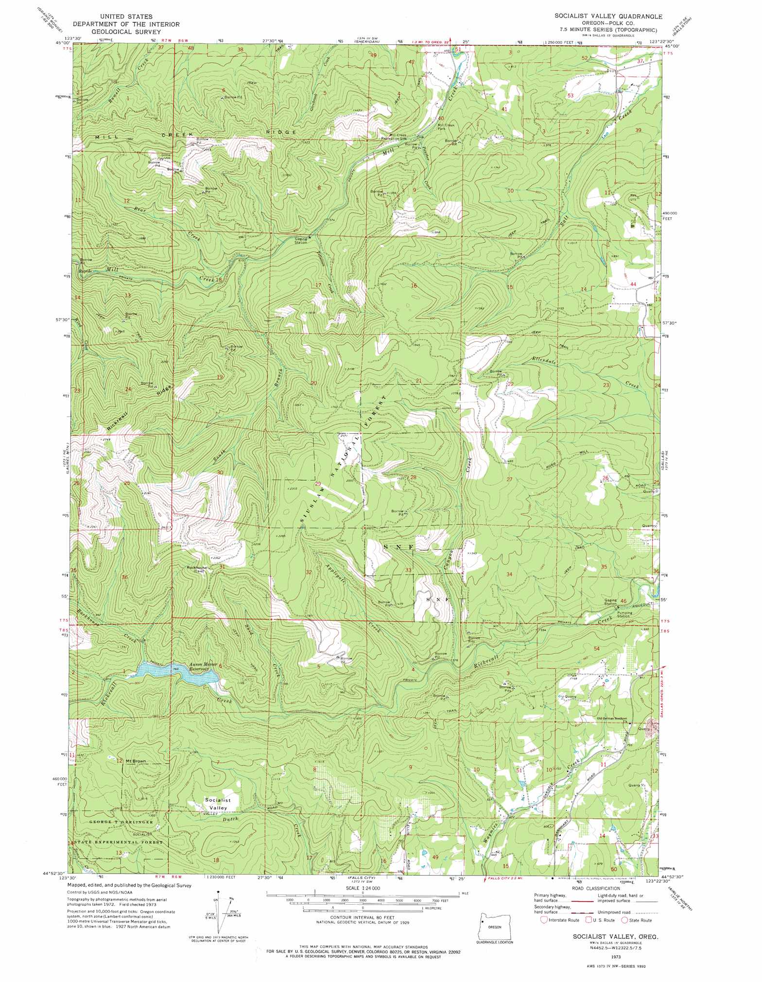
USGS Topo Quad 44123h4 - 1:24,000 scale
| Topo Map Name: | Socialist Valley |
| USGS Topo Quad ID: | 44123h4 |
| Print Size: | ca. 21 1/4" wide x 27" high |
| Southeast Coordinates: | 44.875° N latitude / 123.375° W longitude |
| Map Center Coordinates: | 44.9375° N latitude / 123.4375° W longitude |
| U.S. State: | OR |
| Filename: | o44123h4.jpg |
| Download Map JPG Image: | Socialist Valley topo map 1:24,000 scale |
| Map Type: | Topographic |
| Topo Series: | 7.5´ |
| Map Scale: | 1:24,000 |
| Source of Map Images: | United States Geological Survey (USGS) |
| Alternate Map Versions: |
Socialist Valley OR 1973, updated 1977 Download PDF Buy paper map Socialist Valley OR 2011 Download PDF Buy paper map Socialist Valley OR 2014 Download PDF Buy paper map |
| FStopo: | US Forest Service topo Socialist Valley is available: Download FStopo PDF Download FStopo TIF |
1:24,000 Topo Quads surrounding Socialist Valley
Niagara Creek |
Springer Mountain |
Stony Mountain |
Muddy Valley |
Mcminnville |
Midway |
Grand Ronde |
Sheridan |
Ballston |
Amity |
Warnicke Creek |
Laurel Mountain |
Socialist Valley |
Dallas |
Rickreall |
Valsetz |
Fanno Ridge |
Falls City |
Airlie North |
Monmouth |
Nortons |
Summit |
Kings Valley |
Airlie South |
Lewisburg |
> Back to 44123e1 at 1:100,000 scale
> Back to 44122a1 at 1:250,000 scale
> Back to U.S. Topo Maps home
Socialist Valley topo map: Gazetteer
Socialist Valley: Basins
Socialist Valley elevation 315m 1033′Socialist Valley: Dams
Mercer Dam elevation 221m 725′Socialist Valley: Forests
George T Gerlinger State Experimental Forest elevation 315m 1033′Socialist Valley: Parks
BLM County Park elevation 155m 508′Mill Creek County Park elevation 154m 505′
Socialist Valley: Populated Places
Oakdale elevation 272m 892′Socialist Valley: Reservoirs
Aaron Mercer Reservoir elevation 235m 770′Harvstack Reservoir elevation 148m 485′
Murray Reservoir elevation 139m 456′
Wilson Reservoir elevation 253m 830′
Socialist Valley: Streams
Applegate Creek elevation 172m 564′Bear Creek elevation 200m 656′
Canyon Creek elevation 173m 567′
Panther Creek elevation 155m 508′
Rockhouse Creek elevation 238m 780′
Skid Creek elevation 196m 643′
South Branch Mill Creek elevation 191m 626′
Tillotson Creek elevation 178m 583′
Socialist Valley: Summits
Mount Brown elevation 591m 1938′Socialist Valley digital topo map on disk
Buy this Socialist Valley topo map showing relief, roads, GPS coordinates and other geographical features, as a high-resolution digital map file on DVD: