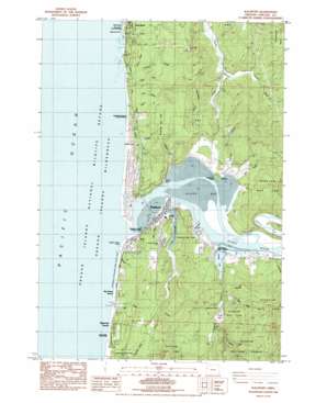
Waldport Topo Map Oregon
To zoom in, hover over the map of Waldport
USGS Topo Quad 44124d1 - 1:24,000 scale
| Topo Map Name: | Waldport |
| USGS Topo Quad ID: | 44124d1 |
| Print Size: | ca. 21 1/4" wide x 27" high |
| Southeast Coordinates: | 44.375° N latitude / 124° W longitude |
| Map Center Coordinates: | 44.4375° N latitude / 124.0625° W longitude |
| U.S. State: | OR |
| Filename: | o44124d1.jpg |
| Download Map JPG Image: | Waldport topo map 1:24,000 scale |
| Map Type: | Topographic |
| Topo Series: | 7.5´ |
| Map Scale: | 1:24,000 |
| Source of Map Images: | United States Geological Survey (USGS) |
| Alternate Map Versions: |
Waldport OR 1984, updated 1984 Download PDF Buy paper map Waldport OR 1984, updated 1984 Download PDF Buy paper map Waldport OR 2011 Download PDF Buy paper map Waldport OR 2014 Download PDF Buy paper map |
| FStopo: | US Forest Service topo Waldport is available: Download FStopo PDF Download FStopo TIF |
1:24,000 Topo Quads surrounding Waldport
Newport North |
Toledo North |
Eddyville |
||
Newport South |
Toledo South |
Elk City |
||
Waldport |
Tidewater |
Hellion Rapids |
||
Yachats |
Cannibal Mountain |
Five Rivers |
||
Heceta Head |
Cummins Peak |
Herman Creek |
> Back to 44124a1 at 1:100,000 scale
> Back to 44124a1 at 1:250,000 scale
> Back to U.S. Topo Maps home
Waldport topo map: Gazetteer
Waldport: Airports
Wakonda Beach State Airport elevation 13m 42′Waldport: Bays
Alsea Bay elevation 0m 0′Waldport: Beaches
Holly Beach elevation 4m 13′Waldport: Bends
Devils Bend elevation 5m 16′Waldport: Canals
Day Drainage Ditch elevation 7m 22′Waldport: Capes
Shepards Point elevation 15m 49′Yaquina John Point elevation 1m 3′
Waldport: Dams
Lint Slough Dam elevation 5m 16′Waldport: Guts
Eckman Slough elevation 6m 19′Lint Slough elevation 3m 9′
McKinney Slough elevation 7m 22′
Waldport: Lakes
Hidden Lake elevation 16m 52′Lotus Lake elevation 23m 75′
Waldport: Mines
Eckman Quarry elevation 61m 200′Waldport: Parks
Alsea Bay - North Bridgehead Wayside (historical) elevation 25m 82′Beachside State Recreation Site elevation 4m 13′
Collins Creek State Park elevation 8m 26′
Driftwood Beach State Recreation Site elevation 13m 42′
Governor Patterson Memorial State Recreation Site elevation 1m 3′
L Presley and Vera C Gill State Park elevation 14m 45′
Seal Rock State Recreation Site elevation 0m 0′
W B Nelson State Recreation Site elevation 7m 22′
William P. Keady State Wayside elevation 5m 16′
Waldport: Populated Places
Bayshore elevation 44m 144′Bayview elevation 16m 52′
Seal Rock elevation 1m 3′
Wakonda Beach elevation 7m 22′
Waldport elevation 2m 6′
Waldport: Post Offices
Bayview Post Office (historical) elevation 16m 52′Collins Post Office (historical) elevation 14m 45′
Lutgens Post Office (historical) elevation 23m 75′
Nice Post Office (historical) elevation 4m 13′
Seal Rock Post Office elevation 1m 3′
Waldport Post Office elevation 2m 6′
Yamada Post Office (historical) elevation 13m 42′
Waldport: Reservoirs
Eckman Lake elevation 6m 19′Lint Slough Reservoir elevation 5m 16′
Waldport: Springs
Little Creek Spring elevation 34m 111′Waldport: Streams
Alsea River elevation 0m 0′Annice Creek elevation 5m 16′
Buckley Creek elevation 0m 0′
Burnham Creek elevation 8m 26′
Collins Creek elevation 0m 0′
Constantine Creek elevation 6m 19′
Darling Creek elevation 29m 95′
Drift Creek elevation 3m 9′
Eckman Creek elevation 6m 19′
Fox Creek elevation 0m 0′
Freeman Creek elevation 6m 19′
Friday Creek elevation 8m 26′
Graves Creek elevation 25m 82′
Hill Creek elevation 0m 0′
Lint Creek elevation 1m 3′
Little Creek elevation 0m 0′
Little Creek elevation 0m 0′
Oliver Creek elevation 13m 42′
Patterson Creek elevation 3m 9′
Red River elevation 2m 6′
South Fork Collins Creek elevation 12m 39′
South Fork Weist Creek elevation 128m 419′
Squaw Creek elevation 0m 0′
Starr Creek elevation 0m 0′
Swede Fork elevation 74m 242′
Swede Fork Eckman Creek elevation 78m 255′
Thursday Creek elevation 19m 62′
Twombly Creek elevation 11m 36′
Walker Creek elevation 0m 0′
Weist Creek elevation 48m 157′
Waldport: Summits
Elephant Rock elevation 0m 0′Mount Eckman elevation 201m 659′
Waldport: Valleys
Howe Canyon elevation 32m 104′Waldport digital topo map on disk
Buy this Waldport topo map showing relief, roads, GPS coordinates and other geographical features, as a high-resolution digital map file on DVD:


