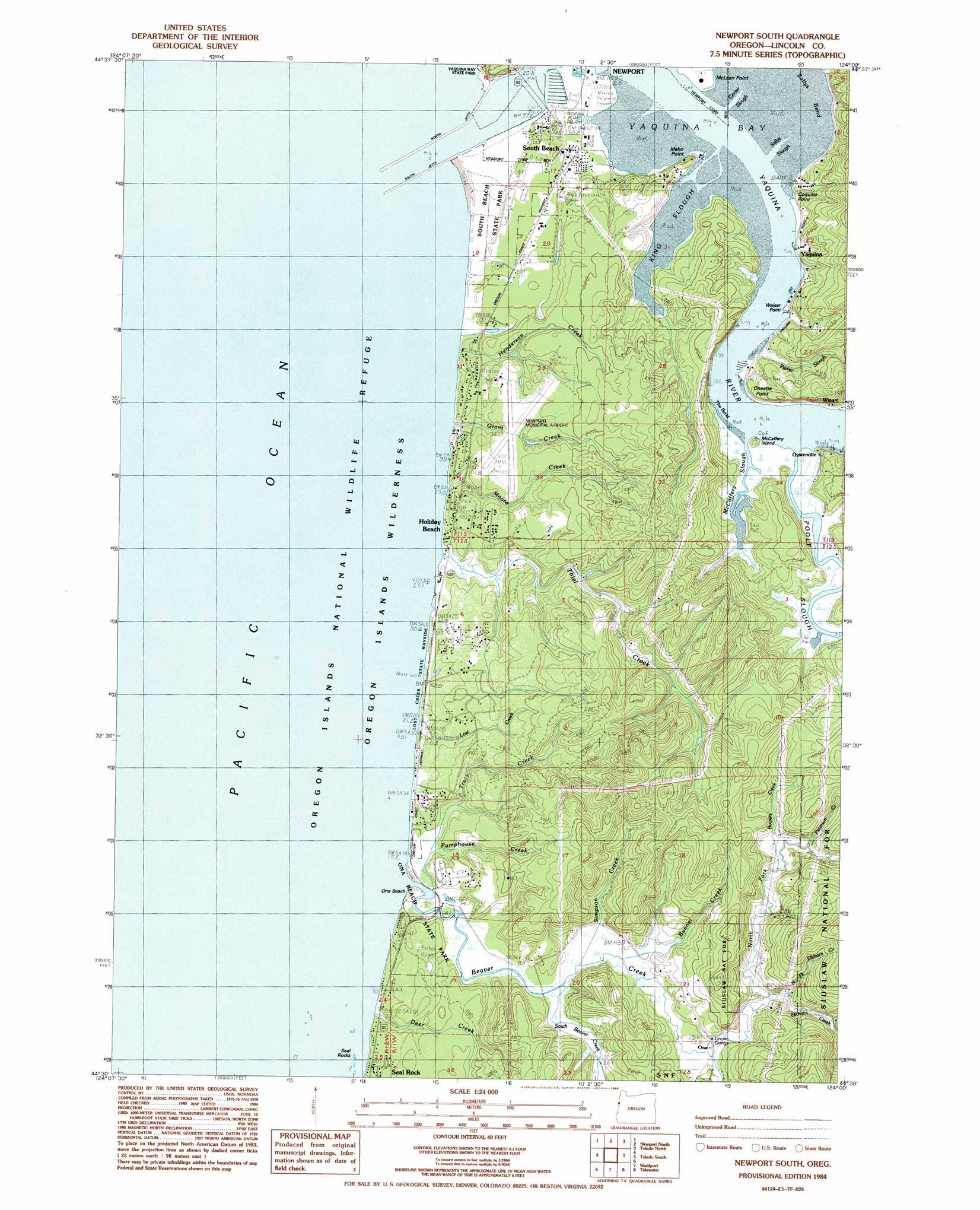
Newport South Topo Map Oregon
To zoom in, hover over the map of Newport South
USGS Topo Quad 44124e1 - 1:24,000 scale
| Topo Map Name: | Newport South |
| USGS Topo Quad ID: | 44124e1 |
| Print Size: | ca. 21 1/4" wide x 27" high |
| Southeast Coordinates: | 44.5° N latitude / 124° W longitude |
| Map Center Coordinates: | 44.5625° N latitude / 124.0625° W longitude |
| U.S. State: | OR |
| Filename: | o44124e1.jpg |
| Download Map JPG Image: | Newport South topo map 1:24,000 scale |
| Map Type: | Topographic |
| Topo Series: | 7.5´ |
| Map Scale: | 1:24,000 |
| Source of Map Images: | United States Geological Survey (USGS) |
| Alternate Map Versions: |
Newport South OR 1984, updated 1985 Download PDF Buy paper map Newport South OR 1984, updated 1985 Download PDF Buy paper map Newport South OR 2011 Download PDF Buy paper map Newport South OR 2014 Download PDF Buy paper map |
| FStopo: | US Forest Service topo Newport South is available: Download FStopo PDF Download FStopo TIF |
1:24,000 Topo Quads surrounding Newport South
Depoe Bay |
Mowrey Landing |
Euchre Mountain |
||
Newport North |
Toledo North |
Eddyville |
||
Newport South |
Toledo South |
Elk City |
||
Waldport |
Tidewater |
Hellion Rapids |
||
Yachats |
Cannibal Mountain |
Five Rivers |
> Back to 44124e1 at 1:100,000 scale
> Back to 44124a1 at 1:250,000 scale
> Back to U.S. Topo Maps home
Newport South topo map: Gazetteer
Newport South: Airports
Newport Municipal Airport elevation 40m 131′Newport South: Bars
South Reef elevation 0m 0′Yaquina Reef elevation 0m 0′
Newport South: Bays
Yaquina Bay elevation 0m 0′Newport South: Beaches
Ona Beach elevation 0m 0′Newport South: Bends
Sallys Bend elevation 0m 0′The Bend elevation 4m 13′
Newport South: Capes
Coquille Point elevation 14m 45′Idaho Point elevation 27m 88′
Oneatta Point elevation 29m 95′
Weiser Point elevation 11m 36′
Newport South: Dams
North Jetty elevation 0m 0′South Jetty elevation 2m 6′
Newport South: Guts
Center Slough elevation 0m 0′Sallys Slough elevation 0m 0′
Newport South: Islands
McCaffrey Island elevation 23m 75′Seal Rocks elevation 0m 0′
Newport South: Parks
Lost Creek State Recreation Site elevation 7m 22′Mike Miller County Park elevation 13m 42′
Ona Beach State Park elevation 26m 85′
Seal Rock County Wayside elevation 0m 0′
South Beach State Park elevation 9m 29′
Yaquina Bay State Recreation Site elevation 25m 82′
Newport South: Populated Places
Forfar elevation 27m 88′Holiday Beach elevation 24m 78′
Ona elevation 13m 42′
Oysterville elevation 0m 0′
South Beach elevation 10m 32′
Yaquina elevation 32m 104′
Newport South: Post Offices
Ona Post Office (historical) elevation 13m 42′Oneatta Post Office (historical) elevation 29m 95′
South Beach Post Office elevation 10m 32′
Winant Post Office (historical) elevation 22m 72′
Yaquina Post Office (historical) elevation 32m 104′
Newport South: Reservoirs
Bay Hills Reservoir elevation 25m 82′Newport South: Streams
Beaver Creek elevation 0m 0′Bowers Creek elevation 24m 78′
Bunnel Creek elevation 12m 39′
Deer Creek elevation 2m 6′
Elkhorn Creek elevation 22m 72′
Grant Creek elevation 0m 0′
Henderson Creek elevation 0m 0′
King Slough elevation 0m 0′
Lost Creek elevation 2m 6′
McCaffery Slough elevation 0m 0′
Moore Creek elevation 0m 0′
North Fork Beaver Creek elevation 13m 42′
North Fork Elkhorn Creek elevation 13m 42′
Parker Slough elevation 2m 6′
Peterson Creek elevation 36m 118′
Poole Slough elevation 0m 0′
Pumphouse Creek elevation 5m 16′
Simpson Creek elevation 11m 36′
South Beaver Creek elevation 12m 39′
Thiel Creek elevation 0m 0′
Tracy Creek elevation 7m 22′
Worth Creek elevation 13m 42′
Yaquina River elevation 0m 0′
Newport South digital topo map on disk
Buy this Newport South topo map showing relief, roads, GPS coordinates and other geographical features, as a high-resolution digital map file on DVD: