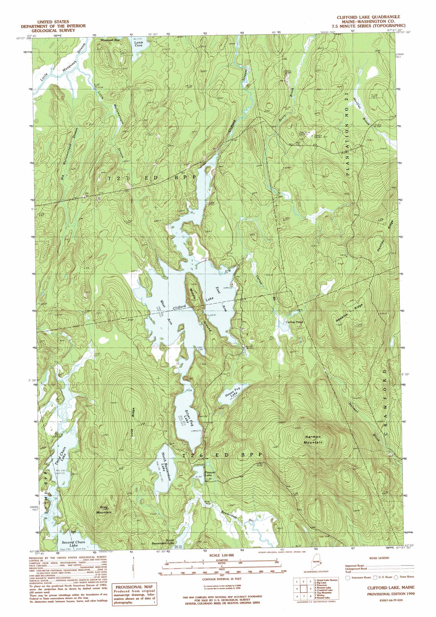
Clifford Lake Topo Map Maine
To zoom in, hover over the map of Clifford Lake
USGS Topo Quad 45067a6 - 1:24,000 scale
| Topo Map Name: | Clifford Lake |
| USGS Topo Quad ID: | 45067a6 |
| Print Size: | ca. 21 1/4" wide x 27" high |
| Southeast Coordinates: | 45° N latitude / 67.625° W longitude |
| Map Center Coordinates: | 45.0625° N latitude / 67.6875° W longitude |
| U.S. State: | ME |
| Filename: | o45067a6.jpg |
| Download Map JPG Image: | Clifford Lake topo map 1:24,000 scale |
| Map Type: | Topographic |
| Topo Series: | 7.5´ |
| Map Scale: | 1:24,000 |
| Source of Map Images: | United States Geological Survey (USGS) |
| Alternate Map Versions: |
Cliford Lake ME 1990, updated 1990 Download PDF Buy paper map Clifford Lake ME 2011 Download PDF Buy paper map Clifford Lake ME 2014 Download PDF Buy paper map |
1:24,000 Topo Quads surrounding Clifford Lake
Scraggly Lake |
Oxbrook Lakes |
Waite |
Toman Ridge |
Kellyland |
Dark Cove Mountain |
Grand Lake Stream |
Big Lake |
Princeton |
Woodland |
Fletcher Peak |
Monroe Lake |
Clifford Lake |
Crawford Lake |
Meddybemp Lake West |
Peaked Mountain |
Tug Mountain |
Wesley |
Round Lake |
Lake Cathance |
Northeast Bluff |
Montegail Pond |
Peaked Mountain Pond |
Bog Lake |
Hadley Lake |
> Back to 45067a1 at 1:100,000 scale
> Back to 45066a1 at 1:250,000 scale
> Back to U.S. Topo Maps home
Clifford Lake topo map: Gazetteer
Clifford Lake: Bays
West Arm Clifford Lake elevation 68m 223′Clifford Lake: Dams
Clifford Dam elevation 69m 226′Clifford Lake: Lakes
Carloe Pond elevation 93m 305′East Arm Clifford Lake elevation 68m 223′
Hosea Pug Lake elevation 82m 269′
North Beaverdam Lake elevation 85m 278′
Possum Lake elevation 80m 262′
Silver Pug Lake elevation 68m 223′
Third Chain Lake elevation 70m 229′
Clifford Lake: Reservoirs
Clifford Lake elevation 69m 226′Clifford Lake: Ridges
Hawkins Ridge elevation 168m 551′Huntley Ridge elevation 149m 488′
Love Ridge elevation 135m 442′
Middle Ground elevation 77m 252′
Clifford Lake: Streams
Big Wallamatogue Stream elevation 62m 203′Carloe Brook elevation 68m 223′
Little Wallamatogue Stream elevation 63m 206′
Clifford Lake: Summits
Grey Mountain elevation 130m 426′Harmon Mountain elevation 230m 754′
Clifford Lake digital topo map on disk
Buy this Clifford Lake topo map showing relief, roads, GPS coordinates and other geographical features, as a high-resolution digital map file on DVD:
Maine, New Hampshire, Rhode Island & Eastern Massachusetts
Buy digital topo maps: Maine, New Hampshire, Rhode Island & Eastern Massachusetts