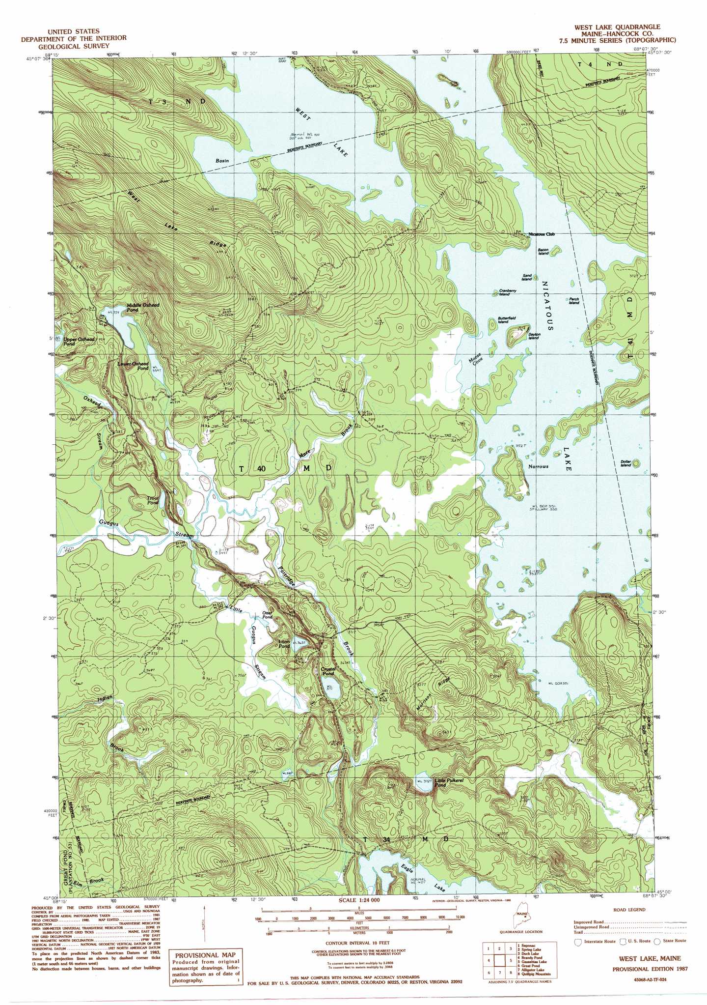
West Lake Topo Map Maine
To zoom in, hover over the map of West Lake
USGS Topo Quad 45068a2 - 1:24,000 scale
| Topo Map Name: | West Lake |
| USGS Topo Quad ID: | 45068a2 |
| Print Size: | ca. 21 1/4" wide x 27" high |
| Southeast Coordinates: | 45° N latitude / 68.125° W longitude |
| Map Center Coordinates: | 45.0625° N latitude / 68.1875° W longitude |
| U.S. State: | ME |
| Filename: | o45068a2.jpg |
| Download Map JPG Image: | West Lake topo map 1:24,000 scale |
| Map Type: | Topographic |
| Topo Series: | 7.5´ |
| Map Scale: | 1:24,000 |
| Source of Map Images: | United States Geological Survey (USGS) |
| Alternate Map Versions: |
Nicatous Lake SW ME 1975, updated 1980 Download PDF Buy paper map West Lake ME 1987, updated 1988 Download PDF Buy paper map West Lake ME 2011 Download PDF Buy paper map West Lake ME 2014 Download PDF Buy paper map |
1:24,000 Topo Quads surrounding West Lake
Lincoln East |
Lee |
Weir Pond |
Bottle Lake |
Scraggly Lake |
Burlington |
Saponac |
Spring Lake |
Duck Lake |
Dark Cove Mountain |
Greenfield |
Brandy Pond |
West Lake |
Gassabias Lake |
Fletcher Peak |
The Horseback |
Great Pond |
Alligator Lake |
Quillpig Mountain |
Peaked Mountain |
Hopkins Pond |
Amherst |
Rocky Pond |
Lead Mountain |
Northeast Bluff |
> Back to 45068a1 at 1:100,000 scale
> Back to 45068a1 at 1:250,000 scale
> Back to U.S. Topo Maps home
West Lake topo map: Gazetteer
West Lake: Bays
Moose Cove elevation 107m 351′West Lake: Islands
Bacon Island elevation 107m 351′Butterfield Island elevation 107m 351′
Cranberry Island elevation 107m 351′
Dayton Island elevation 115m 377′
Dollar Island elevation 107m 351′
Perch Island elevation 107m 351′
Sand Island elevation 107m 351′
West Lake: Lakes
Abarngamook Lake elevation 122m 400′Crystal Pond elevation 113m 370′
Eagle Lake elevation 123m 403′
Little Pickerel Pond elevation 113m 370′
Loon Pond elevation 110m 360′
Lower Oxhead Pond elevation 109m 357′
Middle Oxhead Pond elevation 109m 357′
Otter Pond elevation 105m 344′
Trout Pond elevation 112m 367′
West Lake elevation 122m 400′
West Lake: Ridges
Morrison Ridge elevation 167m 547′West Lake Ridge elevation 244m 800′
West Lake: Streams
Coombs Brook elevation 107m 351′Eagle Brook elevation 123m 403′
Little Guagus Stream elevation 108m 354′
Mace Brook elevation 105m 344′
Oxhead Stream elevation 107m 351′
Partridge Brook elevation 105m 344′
West Lake: Trails
Eagle Lake Trail elevation 126m 413′West Lake digital topo map on disk
Buy this West Lake topo map showing relief, roads, GPS coordinates and other geographical features, as a high-resolution digital map file on DVD:
Maine, New Hampshire, Rhode Island & Eastern Massachusetts
Buy digital topo maps: Maine, New Hampshire, Rhode Island & Eastern Massachusetts