Bottle Lake Topo Map Maine
To zoom in, hover over the map of Bottle Lake
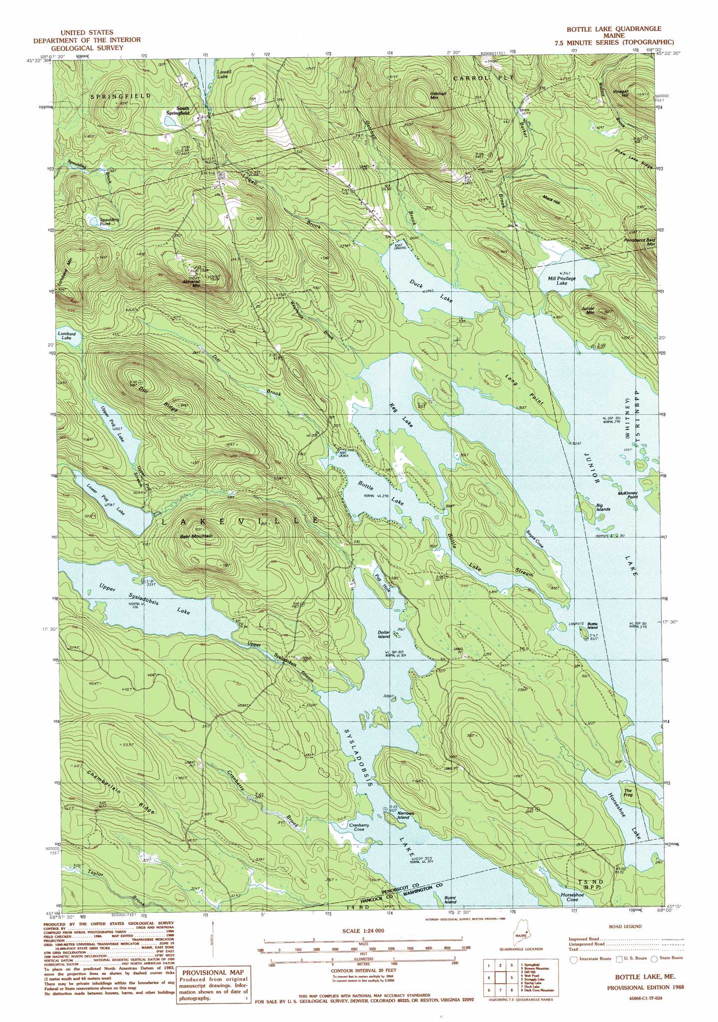
USGS Topo Quad 45068c1 - 1:24,000 scale
| Topo Map Name: | Bottle Lake |
| USGS Topo Quad ID: | 45068c1 |
| Print Size: | ca. 21 1/4" wide x 27" high |
| Southeast Coordinates: | 45.25° N latitude / 68° W longitude |
| Map Center Coordinates: | 45.3125° N latitude / 68.0625° W longitude |
| U.S. State: | ME |
| Filename: | o45068c1.jpg |
| Download Map JPG Image: | Bottle Lake topo map 1:24,000 scale |
| Map Type: | Topographic |
| Topo Series: | 7.5´ |
| Map Scale: | 1:24,000 |
| Source of Map Images: | United States Geological Survey (USGS) |
| Alternate Map Versions: |
Springfield SE ME 1975, updated 1980 Download PDF Buy paper map Bottle Lake ME 1988, updated 1988 Download PDF Buy paper map Bottle Lake ME 1988, updated 1988 Download PDF Buy paper map Bottle Lake ME 2011 Download PDF Buy paper map Bottle Lake ME 2014 Download PDF Buy paper map |
1:24,000 Topo Quads surrounding Bottle Lake
Mattawamkeag |
Kingman |
Potter Hill |
Stetson Mountain |
Brookton |
East Winn |
Springfield |
Bowers Mountain |
Dill Hill |
Farrow Mountain |
Lee |
Weir Pond |
Bottle Lake |
Scraggly Lake |
Oxbrook Lakes |
Saponac |
Spring Lake |
Duck Lake |
Dark Cove Mountain |
Grand Lake Stream |
Brandy Pond |
West Lake |
Gassabias Lake |
Fletcher Peak |
Monroe Lake |
> Back to 45068a1 at 1:100,000 scale
> Back to 45068a1 at 1:250,000 scale
> Back to U.S. Topo Maps home
Bottle Lake topo map: Gazetteer
Bottle Lake: Bays
Boyce Cove elevation 91m 298′Cranberry Cove elevation 92m 301′
Bottle Lake: Capes
Long Point elevation 99m 324′McKinney Point elevation 91m 298′
The Frog elevation 100m 328′
Bottle Lake: Dams
Lowell Dam elevation 189m 620′Bottle Lake: Islands
Big Islands elevation 100m 328′Bottle Island elevation 97m 318′
Burnt Island elevation 93m 305′
Dollar Island elevation 92m 301′
Narrows Island elevation 102m 334′
Bottle Lake: Lakes
Bottle Lake elevation 91m 298′Duck Lake elevation 91m 298′
Horseshoe Lake elevation 91m 298′
Junior Lake elevation 91m 298′
Keg Lake elevation 91m 298′
Lower Pug Lake elevation 121m 396′
Mill Privilege Lake elevation 96m 314′
Pug Hole elevation 92m 301′
Spaulding Pond elevation 213m 698′
Upper Pug Lake elevation 153m 501′
Bottle Lake: Populated Places
South Springfield elevation 206m 675′Bottle Lake: Reservoirs
Lowell Lake elevation 189m 620′Bottle Lake: Ridges
Chamberlain Ridge elevation 190m 623′Dill Ridge elevation 243m 797′
Bottle Lake: Streams
Barker Brook elevation 96m 314′Bottle Lake Stream elevation 91m 298′
Cranberry Brook elevation 92m 301′
Dill Brook elevation 92m 301′
Getchell Brook elevation 91m 298′
Lowell Brook elevation 92m 301′
Upper Pug Stream elevation 121m 396′
Upper Sysladobsis Stream elevation 92m 301′
Weymouth Brook elevation 93m 305′
Bottle Lake: Summits
Almanac Mountain elevation 301m 987′Bear Mountain elevation 233m 764′
Getchell Mountain elevation 299m 980′
Junior Mountain elevation 179m 587′
Lombard Mountain elevation 252m 826′
Mack Hill elevation 173m 567′
Bottle Lake digital topo map on disk
Buy this Bottle Lake topo map showing relief, roads, GPS coordinates and other geographical features, as a high-resolution digital map file on DVD:
Maine, New Hampshire, Rhode Island & Eastern Massachusetts
Buy digital topo maps: Maine, New Hampshire, Rhode Island & Eastern Massachusetts