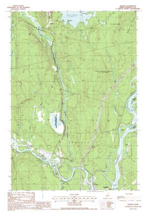
Seboeis Topo Map Maine
To zoom in, hover over the map of Seboeis
USGS Topo Quad 45068c6 - 1:24,000 scale
| Topo Map Name: | Seboeis |
| USGS Topo Quad ID: | 45068c6 |
| Print Size: | ca. 21 1/4" wide x 27" high |
| Southeast Coordinates: | 45.25° N latitude / 68.625° W longitude |
| Map Center Coordinates: | 45.3125° N latitude / 68.6875° W longitude |
| U.S. State: | ME |
| Filename: | o45068c6.jpg |
| Download Map JPG Image: | Seboeis topo map 1:24,000 scale |
| Map Type: | Topographic |
| Topo Series: | 7.5´ |
| Map Scale: | 1:24,000 |
| Source of Map Images: | United States Geological Survey (USGS) |
| Alternate Map Versions: |
Lincoln SW ME 1975, updated 1980 Download PDF Buy paper map Seboeis ME 1988, updated 1988 Download PDF Buy paper map Seboeis ME 2011 Download PDF Buy paper map Seboeis ME 2014 Download PDF Buy paper map |
1:24,000 Topo Quads surrounding Seboeis
> Back to 45068a1 at 1:100,000 scale
> Back to 45068a1 at 1:250,000 scale
> Back to U.S. Topo Maps home
Seboeis topo map: Gazetteer
Seboeis: Capes
Nason Point elevation 69m 226′Townsend Point elevation 69m 226′
Seboeis: Dams
Pond Farm Pond Dam elevation 57m 187′West Enfield Dam elevation 40m 131′
Seboeis: Islands
Beatham Island elevation 48m 157′Big Island elevation 49m 160′
Doe Island elevation 48m 157′
Gordon Island elevation 48m 157′
Lowell Island elevation 49m 160′
Mohawk Island elevation 53m 173′
Seboeis: Parks
Pond Farm State Wildlife Management Area elevation 56m 183′Seboeis: Populated Places
Gilford elevation 77m 252′Seboeis elevation 79m 259′
Seboeis: Reservoirs
Penobscot River Reservoir elevation 40m 131′Pond Farm Pond elevation 57m 187′
Seboeis: Ridges
Carpenter Ridge elevation 109m 357′Hoytville Horseback elevation 65m 213′
Randall Ridge elevation 99m 324′
Seboeis: Streams
Barnes Brook elevation 48m 157′Chesley Brook elevation 52m 170′
Contrary Brook elevation 57m 187′
Gordon Brook elevation 46m 150′
Maxy Brook elevation 46m 150′
Meadow Brook elevation 45m 147′
Merrill Brook elevation 47m 154′
Seboeis Stream elevation 45m 147′
Tate Brook elevation 46m 150′
Seboeis digital topo map on disk
Buy this Seboeis topo map showing relief, roads, GPS coordinates and other geographical features, as a high-resolution digital map file on DVD:
Maine, New Hampshire, Rhode Island & Eastern Massachusetts
Buy digital topo maps: Maine, New Hampshire, Rhode Island & Eastern Massachusetts


