Mattamiscontis Mountain Topo Map Maine
To zoom in, hover over the map of Mattamiscontis Mountain
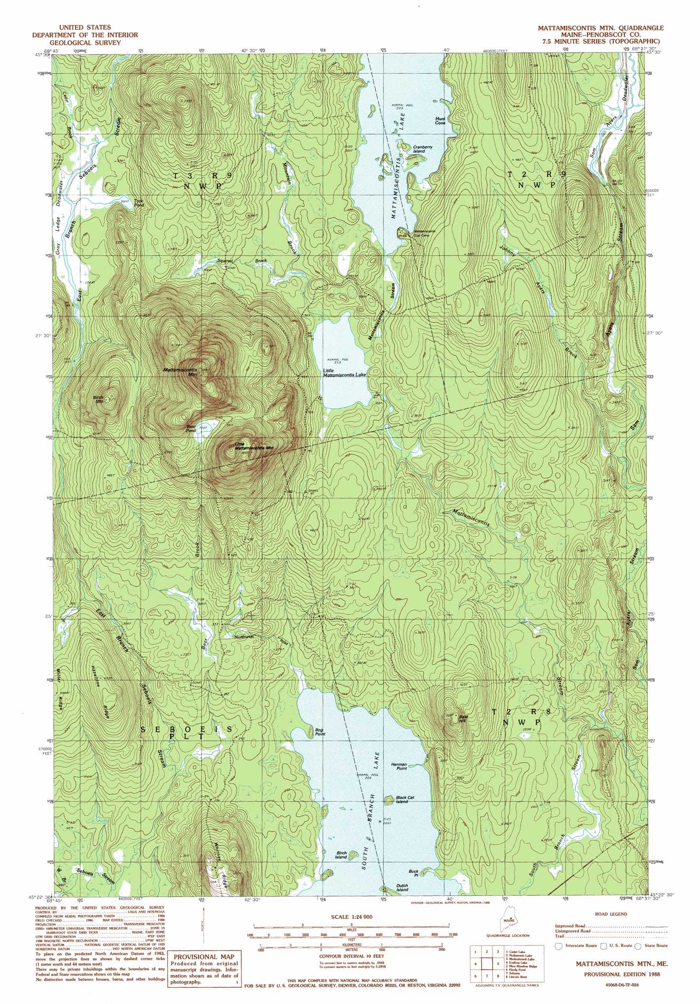
USGS Topo Quad 45068d6 - 1:24,000 scale
| Topo Map Name: | Mattamiscontis Mountain |
| USGS Topo Quad ID: | 45068d6 |
| Print Size: | ca. 21 1/4" wide x 27" high |
| Southeast Coordinates: | 45.375° N latitude / 68.625° W longitude |
| Map Center Coordinates: | 45.4375° N latitude / 68.6875° W longitude |
| U.S. State: | ME |
| Filename: | o45068d6.jpg |
| Download Map JPG Image: | Mattamiscontis Mountain topo map 1:24,000 scale |
| Map Type: | Topographic |
| Topo Series: | 7.5´ |
| Map Scale: | 1:24,000 |
| Source of Map Images: | United States Geological Survey (USGS) |
| Alternate Map Versions: |
Lincoln NW ME 1975, updated 1980 Download PDF Buy paper map Mattamiscontis Mtn ME 1988, updated 1988 Download PDF Buy paper map Mattamiscontis Mountain ME 2011 Download PDF Buy paper map Mattamiscontis Mountain ME 2014 Download PDF Buy paper map |
1:24,000 Topo Quads surrounding Mattamiscontis Mountain
Pemadumcook Lake |
Norcross |
Millinocket |
East Millinocket |
Salmon Stream Lake |
Ragged Mountain |
Cedar Lake |
Nollesemic Lake |
Medunkeunk Lake |
Mattaseunk Lake |
Seboeis Lake |
Endless Lake |
Mattamiscontis Mountain |
Nine Meadow Ridge |
Lincoln Center |
Milo North |
Hardy Pond |
Seboeis |
Lincoln West |
Lincoln East |
Milo South |
Lagrange |
Howland |
Passadumkeag |
Burlington |
> Back to 45068a1 at 1:100,000 scale
> Back to 45068a1 at 1:250,000 scale
> Back to U.S. Topo Maps home
Mattamiscontis Mountain topo map: Gazetteer
Mattamiscontis Mountain: Bays
Hunt Cove elevation 118m 387′Mattamiscontis Mountain: Capes
Bog Point elevation 70m 229′Buck Point elevation 69m 226′
Herman Point elevation 69m 226′
Mattamiscontis Mountain: Islands
Birch Island elevation 69m 226′Black Cat Island elevation 69m 226′
Cranberry Island elevation 119m 390′
Dutch Island elevation 73m 239′
Mattamiscontis Mountain: Lakes
Bear Pond elevation 221m 725′Gray Ledge Deadwater elevation 113m 370′
Little Mattamiscontis Lake elevation 107m 351′
Mattamiscontis Lake elevation 118m 387′
South Branch Lake elevation 69m 226′
Tack Pond elevation 117m 383′
Mattamiscontis Mountain: Ridges
Hazeltine Ridge elevation 150m 492′Whitney Ridge elevation 160m 524′
Mattamiscontis Mountain: Streams
Bear Brook elevation 57m 187′Bog Brook elevation 110m 360′
Cedar Brook elevation 117m 383′
East Branch Seboeis Stream elevation 57m 187′
Johnny Ayers Brook elevation 75m 246′
Mountain Brook elevation 110m 360′
Northwest Inlet elevation 69m 226′
Sam Ayers Stream elevation 72m 236′
South Branch Stream elevation 58m 190′
Squirrel Brook elevation 117m 383′
Sweat Bog Brook elevation 57m 187′
West Branch Seboeis Stream elevation 57m 187′
Mattamiscontis Mountain: Summits
Bald Hill elevation 148m 485′Birch Mountain elevation 228m 748′
Little Mattamiscontis Mountain elevation 333m 1092′
Mattamiscontis Mountain elevation 380m 1246′
Mattamiscontis Mountain: Swamps
Sam Ayers Deadwater elevation 108m 354′Mattamiscontis Mountain: Trails
Shore Road Trail elevation 68m 223′Mattamiscontis Mountain digital topo map on disk
Buy this Mattamiscontis Mountain topo map showing relief, roads, GPS coordinates and other geographical features, as a high-resolution digital map file on DVD:
Maine, New Hampshire, Rhode Island & Eastern Massachusetts
Buy digital topo maps: Maine, New Hampshire, Rhode Island & Eastern Massachusetts