Seboeis Lake Topo Map Maine
To zoom in, hover over the map of Seboeis Lake
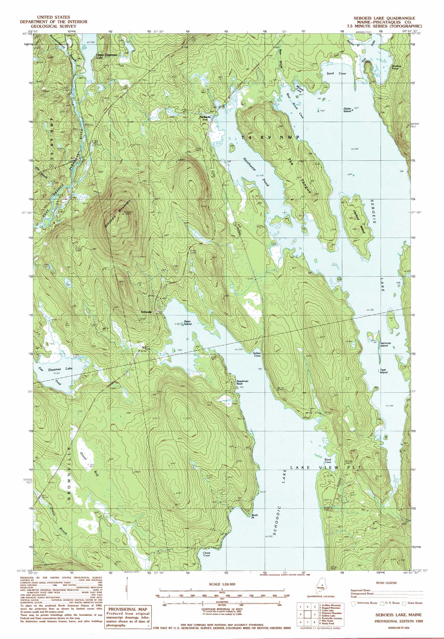
USGS Topo Quad 45068d8 - 1:24,000 scale
| Topo Map Name: | Seboeis Lake |
| USGS Topo Quad ID: | 45068d8 |
| Print Size: | ca. 21 1/4" wide x 27" high |
| Southeast Coordinates: | 45.375° N latitude / 68.875° W longitude |
| Map Center Coordinates: | 45.4375° N latitude / 68.9375° W longitude |
| U.S. State: | ME |
| Filename: | o45068d8.jpg |
| Download Map JPG Image: | Seboeis Lake topo map 1:24,000 scale |
| Map Type: | Topographic |
| Topo Series: | 7.5´ |
| Map Scale: | 1:24,000 |
| Source of Map Images: | United States Geological Survey (USGS) |
| Alternate Map Versions: |
Seboeis Lake ME 1978, updated 1981 Download PDF Buy paper map Seboeis Lake ME 1988, updated 1988 Download PDF Buy paper map Seboeis Lake ME 2011 Download PDF Buy paper map Seboeis Lake ME 2014 Download PDF Buy paper map |
1:24,000 Topo Quads surrounding Seboeis Lake
Wadleigh Mountain |
Nahmakanta Stream |
Pemadumcook Lake |
Norcross |
Millinocket |
Big Shanty Mountain |
Jo-Mary Mountain |
Ragged Mountain |
Cedar Lake |
Nollesemic Lake |
Silver Lake |
Ebeemee Mountain |
Seboeis Lake |
Endless Lake |
Mattamiscontis Mountain |
Sebec Lake East |
Brownville Junction |
Milo North |
Hardy Pond |
Seboeis |
Dover-Foxcroft |
South Sebec |
Milo South |
Lagrange |
Howland |
> Back to 45068a1 at 1:100,000 scale
> Back to 45068a1 at 1:250,000 scale
> Back to U.S. Topo Maps home
Seboeis Lake topo map: Gazetteer
Seboeis Lake: Bays
Bear Brook Cove elevation 133m 436′Chase Cove elevation 131m 429′
Italian Cove elevation 131m 429′
Moose Cove elevation 133m 436′
Rand Cove elevation 132m 433′
Sand Cove elevation 133m 436′
Seboeis Lake: Capes
Birch Point elevation 131m 429′The Tongue elevation 142m 465′
Seboeis Lake: Islands
Deadman Rock elevation 131m 429′Dean Island elevation 131m 429′
Dollar Island elevation 133m 436′
Hammer Island elevation 133m 436′
Leyford Island elevation 143m 469′
Tack Island elevation 133m 436′
Seboeis Lake: Lakes
East Pond elevation 130m 426′Northwest Pond elevation 133m 436′
Shallow Pond elevation 133m 436′
Seboeis Lake: Populated Places
Packards elevation 134m 439′Schoodic elevation 145m 475′
Seboeis Lake: Streams
Bear Brook elevation 133m 436′Hay Brook elevation 132m 433′
Jordan Brook elevation 133m 436′
Pocomoonshine Branch elevation 145m 475′
Seboeis Lake: Summits
Schoodic Mountain elevation 314m 1030′Seboeis Lake: Trails
Carry Trail elevation 145m 475′Norton Trail elevation 149m 488′
Packards Trail elevation 152m 498′
Pleasant River Trail elevation 197m 646′
Seboeis Lake digital topo map on disk
Buy this Seboeis Lake topo map showing relief, roads, GPS coordinates and other geographical features, as a high-resolution digital map file on DVD:
Maine, New Hampshire, Rhode Island & Eastern Massachusetts
Buy digital topo maps: Maine, New Hampshire, Rhode Island & Eastern Massachusetts