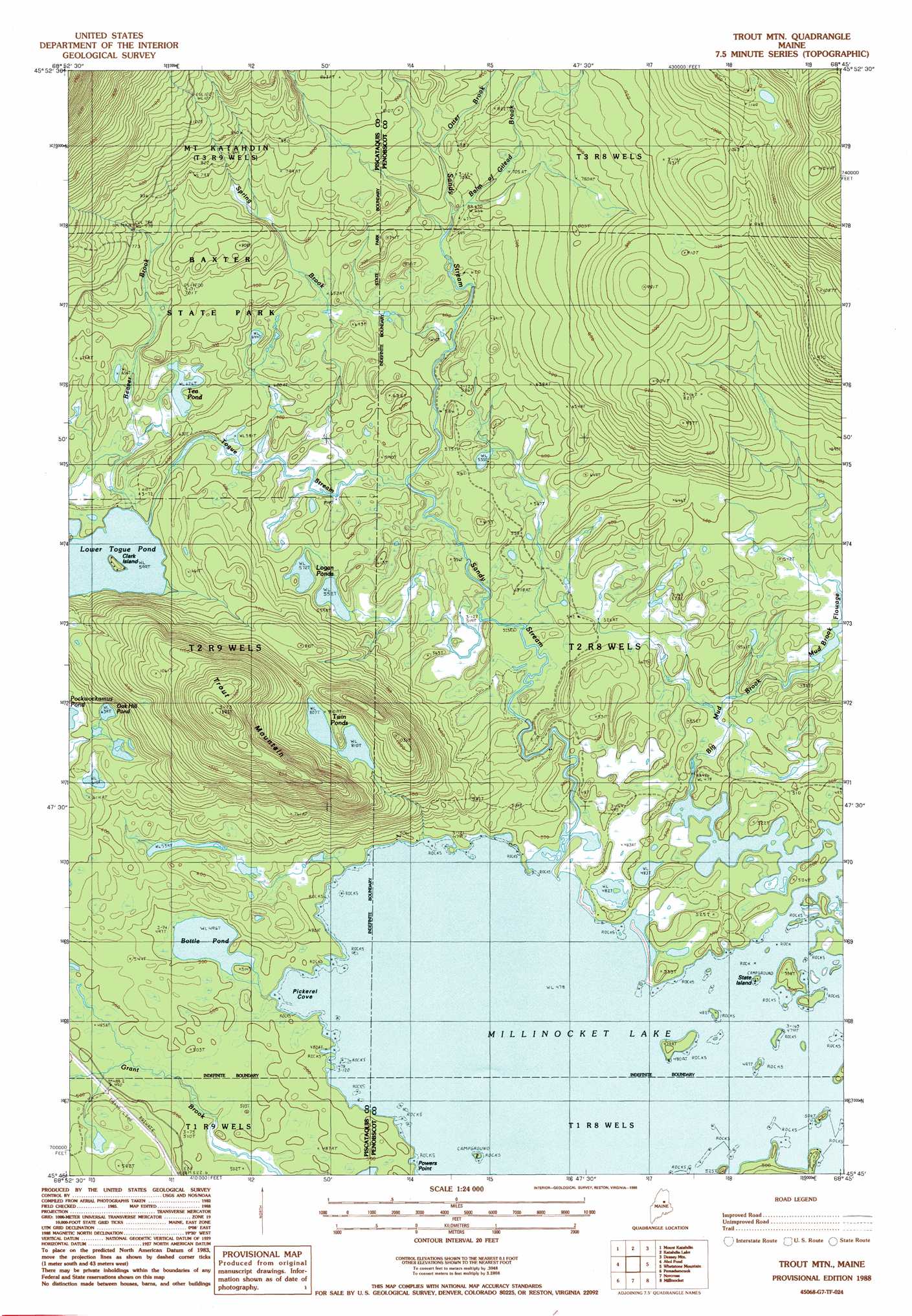
Trout Mountain Topo Map Maine
To zoom in, hover over the map of Trout Mountain
USGS Topo Quad 45068g7 - 1:24,000 scale
| Topo Map Name: | Trout Mountain |
| USGS Topo Quad ID: | 45068g7 |
| Print Size: | ca. 21 1/4" wide x 27" high |
| Southeast Coordinates: | 45.75° N latitude / 68.75° W longitude |
| Map Center Coordinates: | 45.8125° N latitude / 68.8125° W longitude |
| U.S. State: | ME |
| Filename: | o45068g7.jpg |
| Download Map JPG Image: | Trout Mountain topo map 1:24,000 scale |
| Map Type: | Topographic |
| Topo Series: | 7.5´ |
| Map Scale: | 1:24,000 |
| Source of Map Images: | United States Geological Survey (USGS) |
| Alternate Map Versions: |
Trout Mountain ME 1978, updated 1981 Download PDF Buy paper map Trout Mtn ME 1988, updated 1988 Download PDF Buy paper map Trout Mountain ME 2011 Download PDF Buy paper map Trout Mountain ME 2014 Download PDF Buy paper map |
1:24,000 Topo Quads surrounding Trout Mountain
Nesowad Nehunk Lake |
Wassataquoik Lake |
The Traveler |
Bowlin Brook |
Shin Pond |
Doubletop Mountain |
Mount Katahdin |
Katahdin Lake |
Deasey Mountain |
Lookout Mountain |
Rainbow Lake East |
Abol Pond |
Trout Mountain |
Whetstone Mountain |
Stacyville |
Nahmakanta Stream |
Pemadumcook Lake |
Norcross |
Millinocket |
East Millinocket |
Jo-Mary Mountain |
Ragged Mountain |
Cedar Lake |
Nollesemic Lake |
Medunkeunk Lake |
> Back to 45068e1 at 1:100,000 scale
> Back to 45068a1 at 1:250,000 scale
> Back to U.S. Topo Maps home
Trout Mountain topo map: Gazetteer
Trout Mountain: Bays
Pickerel Cove elevation 146m 479′Trout Mountain: Islands
Clark Island elevation 184m 603′State Island elevation 146m 479′
Trout Mountain: Lakes
Bottle Pond elevation 151m 495′Logan Ponds elevation 168m 551′
Lower Togue Pond elevation 182m 597′
Oak Hill Pond elevation 195m 639′
Tea Pond elevation 191m 626′
Twin Ponds elevation 246m 807′
Trout Mountain: Streams
Balm of Gilead Brook elevation 199m 652′Beaver Brook elevation 182m 597′
Big Mud Brook elevation 146m 479′
Otter Brook elevation 213m 698′
Sandy Stream elevation 146m 479′
Spring Brook elevation 169m 554′
Togue Stream elevation 170m 557′
Trout Mountain: Summits
Trout Mountain elevation 423m 1387′Trout Mountain digital topo map on disk
Buy this Trout Mountain topo map showing relief, roads, GPS coordinates and other geographical features, as a high-resolution digital map file on DVD:
Maine, New Hampshire, Rhode Island & Eastern Massachusetts
Buy digital topo maps: Maine, New Hampshire, Rhode Island & Eastern Massachusetts