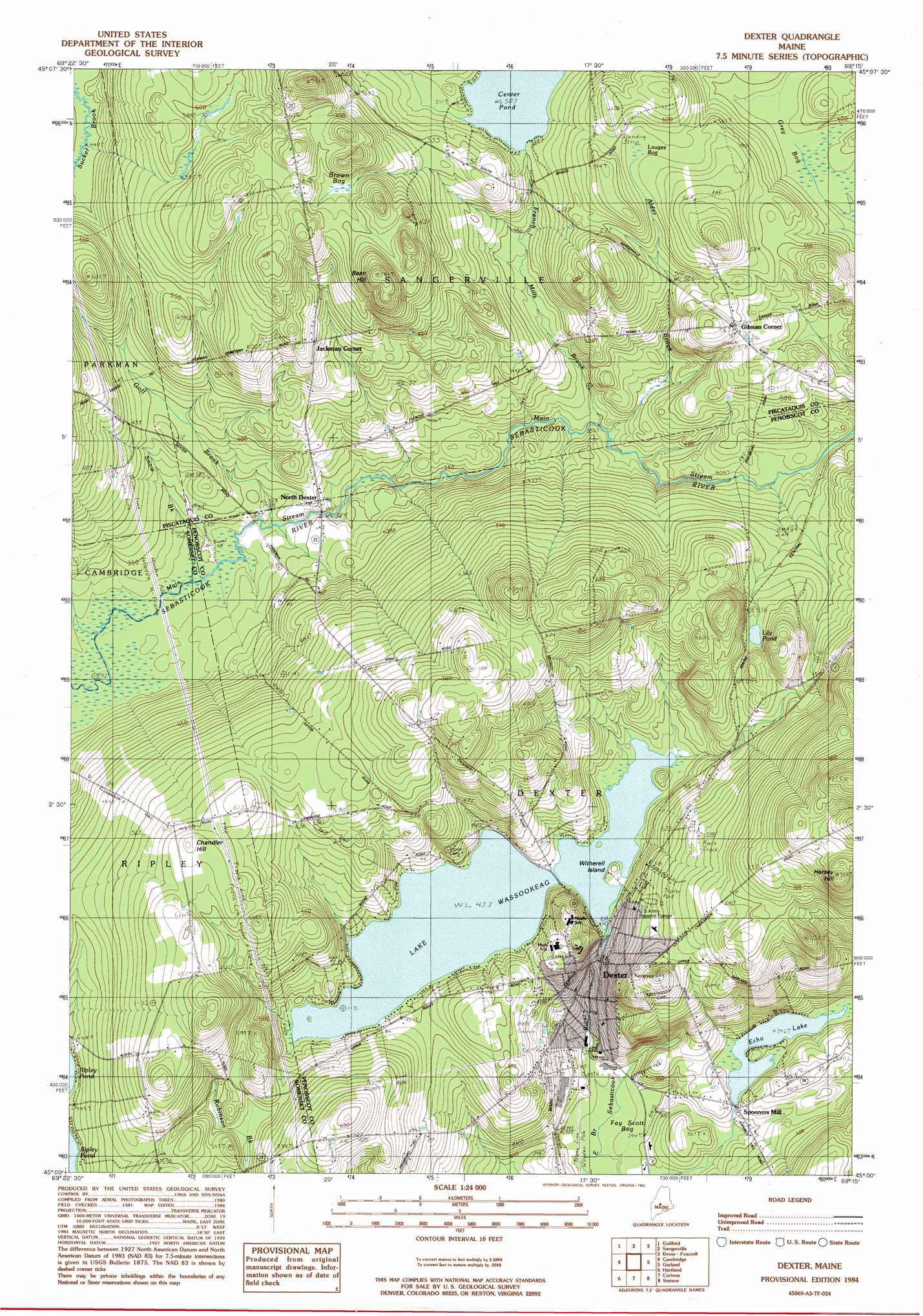
Dexter Topo Map Maine
To zoom in, hover over the map of Dexter
USGS Topo Quad 45069a3 - 1:24,000 scale
| Topo Map Name: | Dexter |
| USGS Topo Quad ID: | 45069a3 |
| Print Size: | ca. 21 1/4" wide x 27" high |
| Southeast Coordinates: | 45° N latitude / 69.25° W longitude |
| Map Center Coordinates: | 45.0625° N latitude / 69.3125° W longitude |
| U.S. State: | ME |
| Filename: | o45069a3.jpg |
| Download Map JPG Image: | Dexter topo map 1:24,000 scale |
| Map Type: | Topographic |
| Topo Series: | 7.5´ |
| Map Scale: | 1:24,000 |
| Source of Map Images: | United States Geological Survey (USGS) |
| Alternate Map Versions: |
Guilford SE ME 1975, updated 1980 Download PDF Buy paper map Dexter ME 1984, updated 1984 Download PDF Buy paper map Dexter ME 1984, updated 1992 Download PDF Buy paper map Dexter ME 2011 Download PDF Buy paper map Dexter ME 2014 Download PDF Buy paper map |
1:24,000 Topo Quads surrounding Dexter
Monson West |
Monson East |
Sebec Lake West |
Sebec Lake East |
Brownville Junction |
Whetstone Pond |
Guilford |
Sangerville |
Dover-Foxcroft |
South Sebec |
Wellington |
Cambridge |
Dexter |
Garland |
Charleston |
Harmony |
Hartland |
Corinna |
Stetson |
West Corinth |
Canaan |
Pittsfield |
Newport |
Plymouth |
Carmel |
> Back to 45069a1 at 1:100,000 scale
> Back to 45068a1 at 1:250,000 scale
> Back to U.S. Topo Maps home
Dexter topo map: Gazetteer
Dexter: Dams
Puffers Pond Dam elevation 105m 344′Wassookeag Lake Dam elevation 132m 433′
Dexter: Islands
Witherell Island elevation 133m 436′Dexter: Lakes
Center Pond elevation 153m 501′Lily Pond elevation 162m 531′
Dexter: Populated Places
Dexter elevation 127m 416′Gilman Corner elevation 172m 564′
Jackman Corner elevation 169m 554′
North Dexter elevation 104m 341′
Spooners Mill elevation 109m 357′
Dexter: Reservoirs
Echo Lake elevation 105m 344′Lake Wassookeag elevation 132m 433′
Dexter: Streams
Alder Brook elevation 111m 364′French Mills Brook elevation 110m 360′
Goff Brook elevation 98m 321′
Snow Brook elevation 96m 314′
Dexter: Summits
Bean Hill elevation 239m 784′Chandler Hill elevation 194m 636′
Hersey Hill elevation 268m 879′
Dexter: Swamps
Brown Bog elevation 191m 626′Fay Scott Bog elevation 89m 291′
Grey Bog elevation 149m 488′
Lougee Bog elevation 170m 557′
Dexter digital topo map on disk
Buy this Dexter topo map showing relief, roads, GPS coordinates and other geographical features, as a high-resolution digital map file on DVD:
Maine, New Hampshire, Rhode Island & Eastern Massachusetts
Buy digital topo maps: Maine, New Hampshire, Rhode Island & Eastern Massachusetts