Guilford Topo Map Maine
To zoom in, hover over the map of Guilford
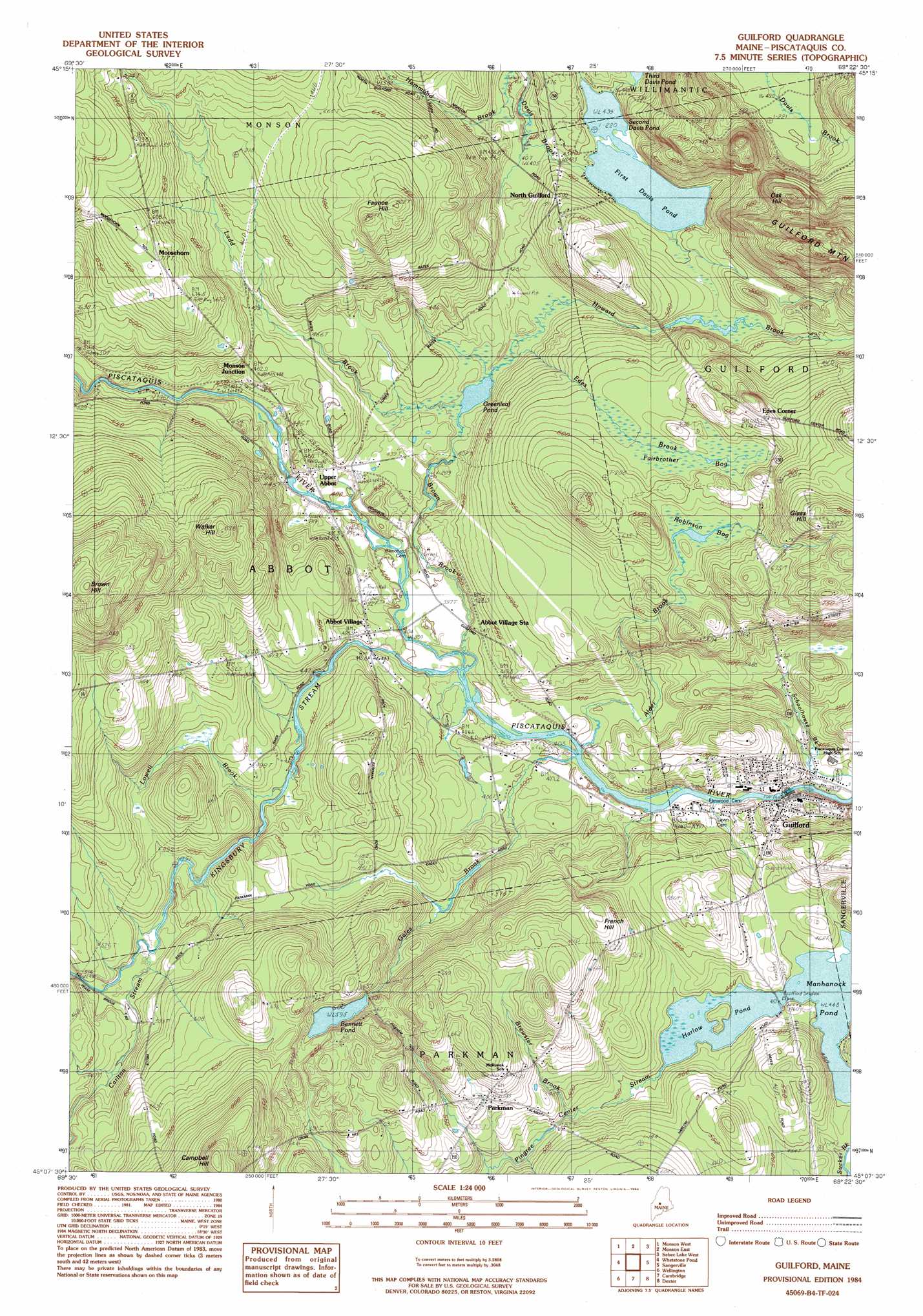
USGS Topo Quad 45069b4 - 1:24,000 scale
| Topo Map Name: | Guilford |
| USGS Topo Quad ID: | 45069b4 |
| Print Size: | ca. 21 1/4" wide x 27" high |
| Southeast Coordinates: | 45.125° N latitude / 69.375° W longitude |
| Map Center Coordinates: | 45.1875° N latitude / 69.4375° W longitude |
| U.S. State: | ME |
| Filename: | o45069b4.jpg |
| Download Map JPG Image: | Guilford topo map 1:24,000 scale |
| Map Type: | Topographic |
| Topo Series: | 7.5´ |
| Map Scale: | 1:24,000 |
| Source of Map Images: | United States Geological Survey (USGS) |
| Alternate Map Versions: |
Guilford NW ME 1975, updated 1980 Download PDF Buy paper map Guilford ME 1984, updated 1984 Download PDF Buy paper map Guilford ME 1984, updated 1984 Download PDF Buy paper map Guilford ME 2011 Download PDF Buy paper map Guilford ME 2014 Download PDF Buy paper map |
1:24,000 Topo Quads surrounding Guilford
Big Squaw Pond |
Greenville |
Barren Mountain West |
Barren Mountain East |
Silver Lake |
Bald Mountain Pond |
Monson West |
Monson East |
Sebec Lake West |
Sebec Lake East |
Foster Ridge |
Whetstone Pond |
Guilford |
Sangerville |
Dover-Foxcroft |
Kingsbury |
Wellington |
Cambridge |
Dexter |
Garland |
Arbens |
Harmony |
Hartland |
Corinna |
Stetson |
> Back to 45069a1 at 1:100,000 scale
> Back to 45068a1 at 1:250,000 scale
> Back to U.S. Topo Maps home
Guilford topo map: Gazetteer
Guilford: Airports
Guilford Seaplane Base elevation 138m 452′Guilford: Dams
First Davis Pond Dam elevation 134m 439′Guilford Industries Dam elevation 115m 377′
Guilford: Lakes
Bennett Pond elevation 181m 593′Greenleaf Pond elevation 122m 400′
Harlow Pond elevation 136m 446′
Second Davis Pond elevation 134m 439′
Guilford: Populated Places
Abbot Village elevation 137m 449′Edes Corner elevation 197m 646′
Guilford elevation 115m 377′
Monson Junction elevation 145m 475′
Moosehorn elevation 218m 715′
North Guilford elevation 160m 524′
Parkman elevation 174m 570′
Upper Abbot elevation 148m 485′
Guilford: Reservoirs
First Davis Pond elevation 134m 439′Piscataquis River Reservoir elevation 115m 377′
Guilford: Streams
Alder Brook elevation 117m 383′Brewster Brook elevation 142m 465′
Brown Brook elevation 117m 383′
Carlton Stream elevation 145m 475′
Edes Brook elevation 126m 413′
Gales Brook elevation 116m 380′
Howard Brook elevation 124m 406′
Kingsbury Stream elevation 117m 383′
Ladd Brook elevation 122m 400′
Lowell Brook elevation 134m 439′
Pingree Center Stream elevation 141m 462′
Guilford: Summits
Brown Hill elevation 305m 1000′Campbell Hill elevation 291m 954′
Faunce Hill elevation 238m 780′
French Hill elevation 198m 649′
Glass Hill elevation 255m 836′
Oak Hill elevation 269m 882′
Walker Hill elevation 242m 793′
Guilford: Swamps
Fairbrother Bog elevation 175m 574′Robinson Bog elevation 176m 577′
Guilford digital topo map on disk
Buy this Guilford topo map showing relief, roads, GPS coordinates and other geographical features, as a high-resolution digital map file on DVD:
Maine, New Hampshire, Rhode Island & Eastern Massachusetts
Buy digital topo maps: Maine, New Hampshire, Rhode Island & Eastern Massachusetts