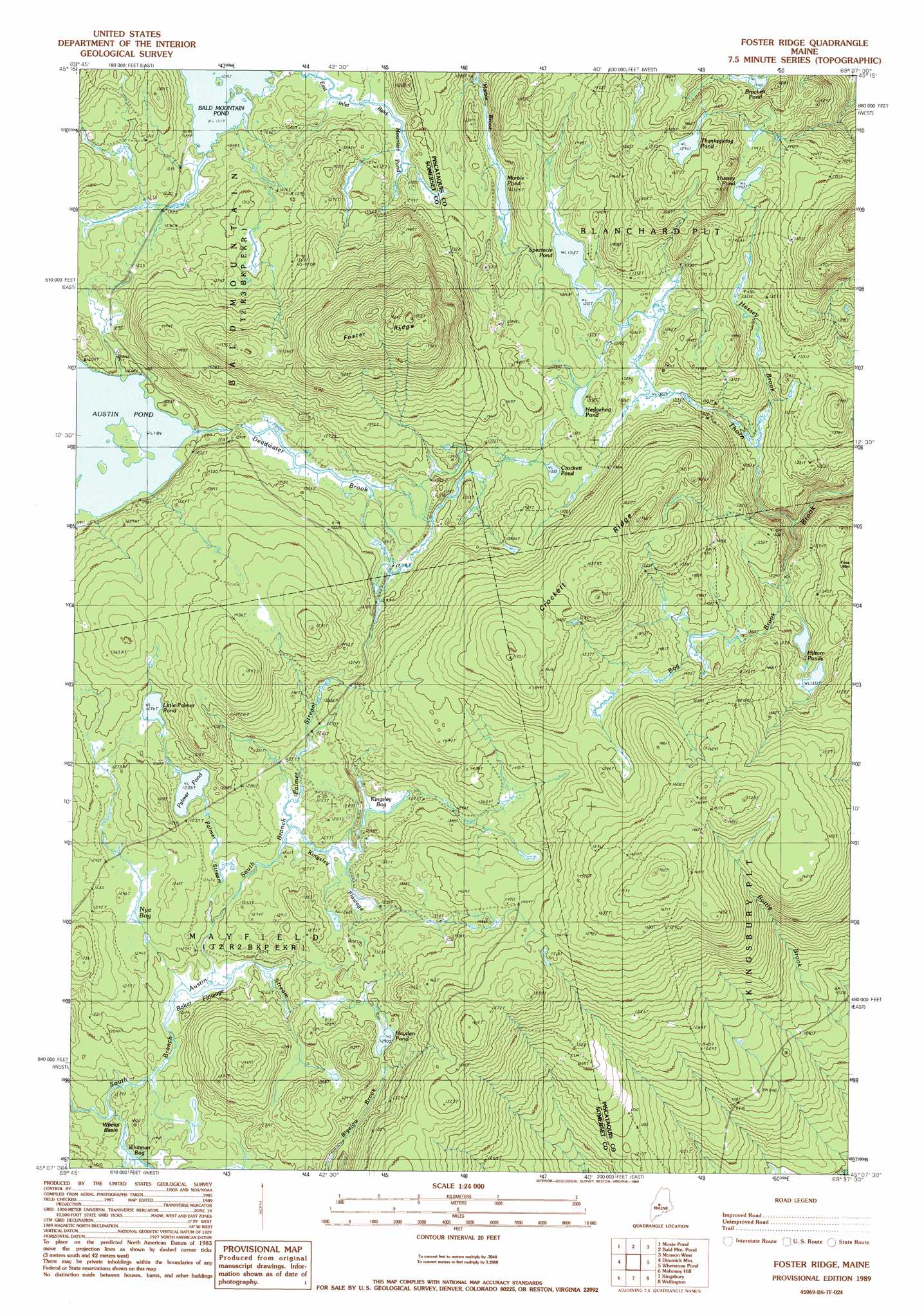
Foster Ridge Topo Map Maine
To zoom in, hover over the map of Foster Ridge
USGS Topo Quad 45069b6 - 1:24,000 scale
| Topo Map Name: | Foster Ridge |
| USGS Topo Quad ID: | 45069b6 |
| Print Size: | ca. 21 1/4" wide x 27" high |
| Southeast Coordinates: | 45.125° N latitude / 69.625° W longitude |
| Map Center Coordinates: | 45.1875° N latitude / 69.6875° W longitude |
| U.S. State: | ME |
| Filename: | o45069b6.jpg |
| Download Map JPG Image: | Foster Ridge topo map 1:24,000 scale |
| Map Type: | Topographic |
| Topo Series: | 7.5´ |
| Map Scale: | 1:24,000 |
| Source of Map Images: | United States Geological Survey (USGS) |
| Alternate Map Versions: |
Kingsbury NW ME 1975, updated 1980 Download PDF Buy paper map Foster Ridge ME 1989, updated 1989 Download PDF Buy paper map Foster Ridge ME 2011 Download PDF Buy paper map Foster Ridge ME 2014 Download PDF Buy paper map |
1:24,000 Topo Quads surrounding Foster Ridge
Black Brook Pond |
Indian Pond South |
Big Squaw Pond |
Greenville |
Barren Mountain West |
The Forks |
Moxie Pond |
Bald Mountain Pond |
Monson West |
Monson East |
Caratunk |
Dimmick Mountain |
Foster Ridge |
Whetstone Pond |
Guilford |
Bingham |
Mahoney Hill |
Kingsbury |
Wellington |
Cambridge |
Embden Pond |
Solon |
Arbens |
Harmony |
Hartland |
> Back to 45069a1 at 1:100,000 scale
> Back to 45068a1 at 1:250,000 scale
> Back to U.S. Topo Maps home
Foster Ridge topo map: Gazetteer
Foster Ridge: Basins
Weeks Basin elevation 346m 1135′Foster Ridge: Lakes
Austin Pond elevation 360m 1181′Baker Flowage elevation 356m 1167′
Brackett Pond elevation 468m 1535′
Crockett Pond elevation 407m 1335′
Hayden Pond elevation 402m 1318′
Hedgehog Pond elevation 413m 1354′
Hilton Ponds elevation 426m 1397′
Hussey Pond elevation 485m 1591′
Kingsley Bog elevation 381m 1250′
Little Palmer Pond elevation 389m 1276′
Marble Pond elevation 390m 1279′
Nye Bog elevation 374m 1227′
Palmer Pond elevation 383m 1256′
Spectacle Pond elevation 403m 1322′
Thanksgiving Pond elevation 486m 1594′
Foster Ridge: Ridges
Crockett Ridge elevation 494m 1620′Foster Ridge elevation 587m 1925′
Foster Ridge: Streams
Bog Brook elevation 361m 1184′Deadwater Brook elevation 363m 1190′
Hussey Brook elevation 387m 1269′
Palmer Stream elevation 359m 1177′
South Branch Palmer Stream elevation 366m 1200′
Foster Ridge: Swamps
Kingsley Flowage elevation 378m 1240′Whitman Bog elevation 355m 1164′
Foster Ridge digital topo map on disk
Buy this Foster Ridge topo map showing relief, roads, GPS coordinates and other geographical features, as a high-resolution digital map file on DVD:
Maine, New Hampshire, Rhode Island & Eastern Massachusetts
Buy digital topo maps: Maine, New Hampshire, Rhode Island & Eastern Massachusetts