The Forks Topo Map Maine
To zoom in, hover over the map of The Forks
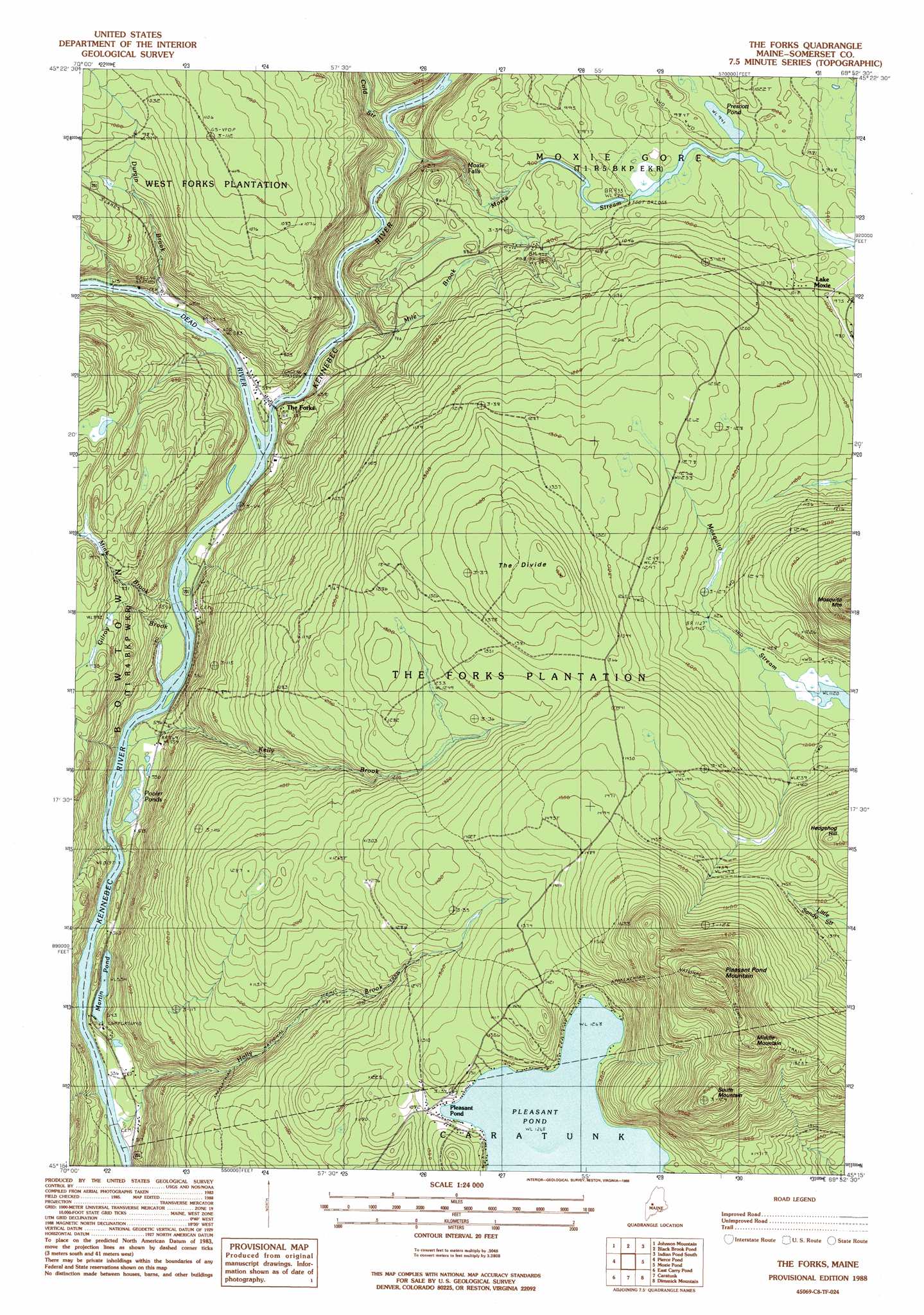
USGS Topo Quad 45069c8 - 1:24,000 scale
| Topo Map Name: | The Forks |
| USGS Topo Quad ID: | 45069c8 |
| Print Size: | ca. 21 1/4" wide x 27" high |
| Southeast Coordinates: | 45.25° N latitude / 69.875° W longitude |
| Map Center Coordinates: | 45.3125° N latitude / 69.9375° W longitude |
| U.S. State: | ME |
| Filename: | o45069c8.jpg |
| Download Map JPG Image: | The Forks topo map 1:24,000 scale |
| Map Type: | Topographic |
| Topo Series: | 7.5´ |
| Map Scale: | 1:24,000 |
| Source of Map Images: | United States Geological Survey (USGS) |
| Alternate Map Versions: |
The Forks ME 1977, updated 1981 Download PDF Buy paper map The Forks ME 1988, updated 1988 Download PDF Buy paper map The Forks ME 1988, updated 1988 Download PDF Buy paper map The Forks ME 2011 Download PDF Buy paper map The Forks ME 2014 Download PDF Buy paper map |
1:24,000 Topo Quads surrounding The Forks
Catheart Mountain |
Long Pond |
Misery Knob |
Indian Pond North |
Moosehead |
Enchanted Pond |
Johnson Mountain |
Black Brook Pond |
Indian Pond South |
Big Squaw Pond |
Basin Mountain |
Pierce Pond |
The Forks |
Moxie Pond |
Bald Mountain Pond |
Little Bigelow Mountain |
East Carry Pond |
Caratunk |
Dimmick Mountain |
Foster Ridge |
Poplar Mountain |
Witham Mountain |
Bingham |
Mahoney Hill |
Kingsbury |
> Back to 45069a1 at 1:100,000 scale
> Back to 45068a1 at 1:250,000 scale
> Back to U.S. Topo Maps home
The Forks topo map: Gazetteer
The Forks: Falls
Moxie Falls elevation 220m 721′The Forks: Lakes
Martin Pond elevation 165m 541′Pleasant Pond elevation 386m 1266′
Pooler Ponds elevation 163m 534′
Prescott Pond elevation 286m 938′
The Forks: Populated Places
Lake Moxie elevation 310m 1017′Pleasant Pond elevation 390m 1279′
The Forks elevation 176m 577′
The Forks: Ridges
The Divide elevation 454m 1489′The Forks: Streams
Cold Stream elevation 198m 649′Dead River elevation 171m 561′
Durgin Brook elevation 177m 580′
Gilroy Brook elevation 167m 547′
Holly Brook elevation 151m 495′
Kelly Brook elevation 158m 518′
Mile Brook elevation 177m 580′
Mink Brook elevation 166m 544′
Moxie Stream elevation 183m 600′
The Forks: Summits
Middle Mountain elevation 683m 2240′Pleasant Pond Mountain elevation 746m 2447′
South Mountain elevation 640m 2099′
The Forks digital topo map on disk
Buy this The Forks topo map showing relief, roads, GPS coordinates and other geographical features, as a high-resolution digital map file on DVD:
Maine, New Hampshire, Rhode Island & Eastern Massachusetts
Buy digital topo maps: Maine, New Hampshire, Rhode Island & Eastern Massachusetts