Jo-Mary Mountain Topo Map Maine
To zoom in, hover over the map of Jo-Mary Mountain
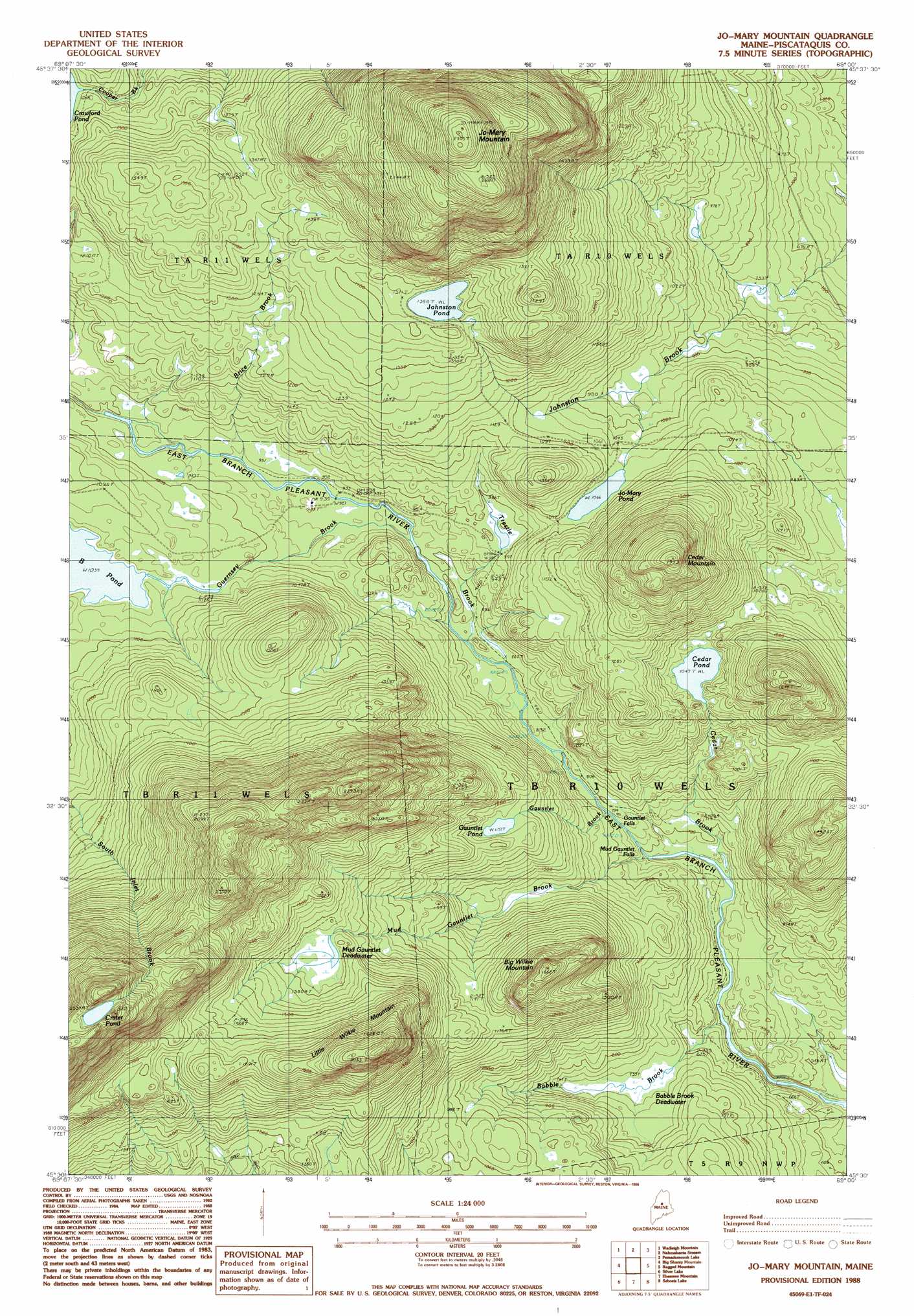
USGS Topo Quad 45069e1 - 1:24,000 scale
| Topo Map Name: | Jo-Mary Mountain |
| USGS Topo Quad ID: | 45069e1 |
| Print Size: | ca. 21 1/4" wide x 27" high |
| Southeast Coordinates: | 45.5° N latitude / 69° W longitude |
| Map Center Coordinates: | 45.5625° N latitude / 69.0625° W longitude |
| U.S. State: | ME |
| Filename: | o45069e1.jpg |
| Download Map JPG Image: | Jo-Mary Mountain topo map 1:24,000 scale |
| Map Type: | Topographic |
| Topo Series: | 7.5´ |
| Map Scale: | 1:24,000 |
| Source of Map Images: | United States Geological Survey (USGS) |
| Alternate Map Versions: |
Jo-Mary Mountain ME 1978, updated 1981 Download PDF Buy paper map Jo-Mary Mountain ME 1988, updated 1988 Download PDF Buy paper map Jo-Mary Mountain ME 2011 Download PDF Buy paper map Jo-Mary Mountain ME 2014 Download PDF Buy paper map |
1:24,000 Topo Quads surrounding Jo-Mary Mountain
Caribou Lake South |
Rainbow Lake West |
Rainbow Lake East |
Abol Pond |
Trout Mountain |
Farrar Mountain |
Wadleigh Mountain |
Nahmakanta Stream |
Pemadumcook Lake |
Norcross |
Hay Mountain |
Big Shanty Mountain |
Jo-Mary Mountain |
Ragged Mountain |
Cedar Lake |
Barren Mountain East |
Silver Lake |
Ebeemee Mountain |
Seboeis Lake |
Endless Lake |
Sebec Lake West |
Sebec Lake East |
Brownville Junction |
Milo North |
Hardy Pond |
> Back to 45069e1 at 1:100,000 scale
> Back to 45068a1 at 1:250,000 scale
> Back to U.S. Topo Maps home
Jo-Mary Mountain topo map: Gazetteer
Jo-Mary Mountain: Falls
Gauntlet Falls elevation 234m 767′Mud Gauntlet Falls elevation 225m 738′
Jo-Mary Mountain: Lakes
Cedar Pond elevation 320m 1049′Crater Pond elevation 769m 2522′
Gauntlet Pond elevation 344m 1128′
Johnston Pond elevation 413m 1354′
Jo-Mary Pond elevation 324m 1062′
Mud Gauntlet Deadwater elevation 417m 1368′
Jo-Mary Mountain: Streams
Babble Brook elevation 192m 629′Brice Brook elevation 285m 935′
Cedar Brook elevation 198m 649′
Gauntlet Brook elevation 242m 793′
Guernsey Brook elevation 299m 980′
Mud Gauntlet Brook elevation 218m 715′
Trestle Brook elevation 262m 859′
Jo-Mary Mountain: Summits
Big Wilkie Mountain elevation 498m 1633′Cedar Mountain elevation 587m 1925′
Jo-Mary Mountain elevation 881m 2890′
Little Wilkie Mountain elevation 630m 2066′
Jo-Mary Mountain: Swamps
Babble Brook Deadwater elevation 223m 731′Jo-Mary Mountain digital topo map on disk
Buy this Jo-Mary Mountain topo map showing relief, roads, GPS coordinates and other geographical features, as a high-resolution digital map file on DVD:
Maine, New Hampshire, Rhode Island & Eastern Massachusetts
Buy digital topo maps: Maine, New Hampshire, Rhode Island & Eastern Massachusetts