Nahmakanta Stream Topo Map Maine
To zoom in, hover over the map of Nahmakanta Stream
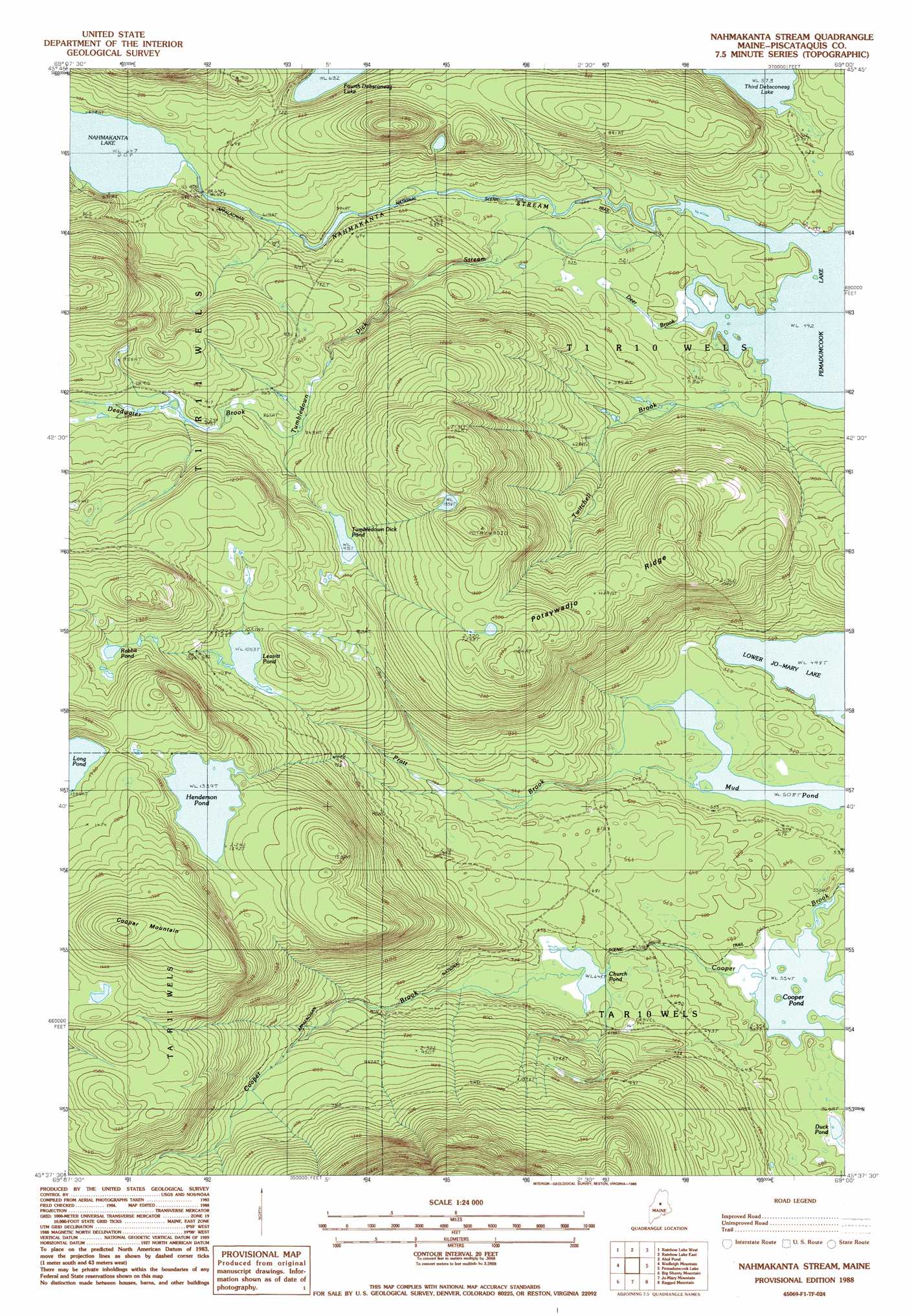
USGS Topo Quad 45069f1 - 1:24,000 scale
| Topo Map Name: | Nahmakanta Stream |
| USGS Topo Quad ID: | 45069f1 |
| Print Size: | ca. 21 1/4" wide x 27" high |
| Southeast Coordinates: | 45.625° N latitude / 69° W longitude |
| Map Center Coordinates: | 45.6875° N latitude / 69.0625° W longitude |
| U.S. State: | ME |
| Filename: | o45069f1.jpg |
| Download Map JPG Image: | Nahmakanta Stream topo map 1:24,000 scale |
| Map Type: | Topographic |
| Topo Series: | 7.5´ |
| Map Scale: | 1:24,000 |
| Source of Map Images: | United States Geological Survey (USGS) |
| Alternate Map Versions: |
Nahamakanta Stream ME 1978, updated 1981 Download PDF Buy paper map Nahmakanta Stream ME 1988, updated 1988 Download PDF Buy paper map Nahmakanta Stream ME 1988, updated 1988 Download PDF Buy paper map Nahmakanta Stream ME 2011 Download PDF Buy paper map Nahmakanta Stream ME 2014 Download PDF Buy paper map |
1:24,000 Topo Quads surrounding Nahmakanta Stream
Caribou Lake North |
Harrington Lake |
Doubletop Mountain |
Mount Katahdin |
Katahdin Lake |
Caribou Lake South |
Rainbow Lake West |
Rainbow Lake East |
Abol Pond |
Trout Mountain |
Farrar Mountain |
Wadleigh Mountain |
Nahmakanta Stream |
Pemadumcook Lake |
Norcross |
Hay Mountain |
Big Shanty Mountain |
Jo-Mary Mountain |
Ragged Mountain |
Cedar Lake |
Barren Mountain East |
Silver Lake |
Ebeemee Mountain |
Seboeis Lake |
Endless Lake |
> Back to 45069e1 at 1:100,000 scale
> Back to 45068a1 at 1:250,000 scale
> Back to U.S. Topo Maps home
Nahmakanta Stream topo map: Gazetteer
Nahmakanta Stream: Lakes
Church Pond elevation 196m 643′Cooper Pond elevation 169m 554′
Duck Pond elevation 170m 557′
Henderson Pond elevation 408m 1338′
Leavitt Pond elevation 321m 1053′
Lower Jo-Mary Lake elevation 151m 495′
Mud Pond elevation 155m 508′
Rabbit Pond elevation 384m 1259′
Tumbledown Dick Pond elevation 303m 994′
Nahmakanta Stream: Ridges
Potaywadjo Ridge elevation 384m 1259′Nahmakanta Stream: Streams
Cooper Brook elevation 169m 554′Deadwater Brook elevation 261m 856′
Deer Brook elevation 150m 492′
Nahmakanta Stream elevation 150m 492′
Pratt Brook elevation 155m 508′
Prentiss Brook elevation 197m 646′
Tumbledown Dick Stream elevation 158m 518′
Twitchell Brook elevation 150m 492′
Nahmakanta Stream: Summits
Cooper Mountain elevation 569m 1866′Nahmakanta Stream digital topo map on disk
Buy this Nahmakanta Stream topo map showing relief, roads, GPS coordinates and other geographical features, as a high-resolution digital map file on DVD:
Maine, New Hampshire, Rhode Island & Eastern Massachusetts
Buy digital topo maps: Maine, New Hampshire, Rhode Island & Eastern Massachusetts