Tim Mountain Topo Map Maine
To zoom in, hover over the map of Tim Mountain
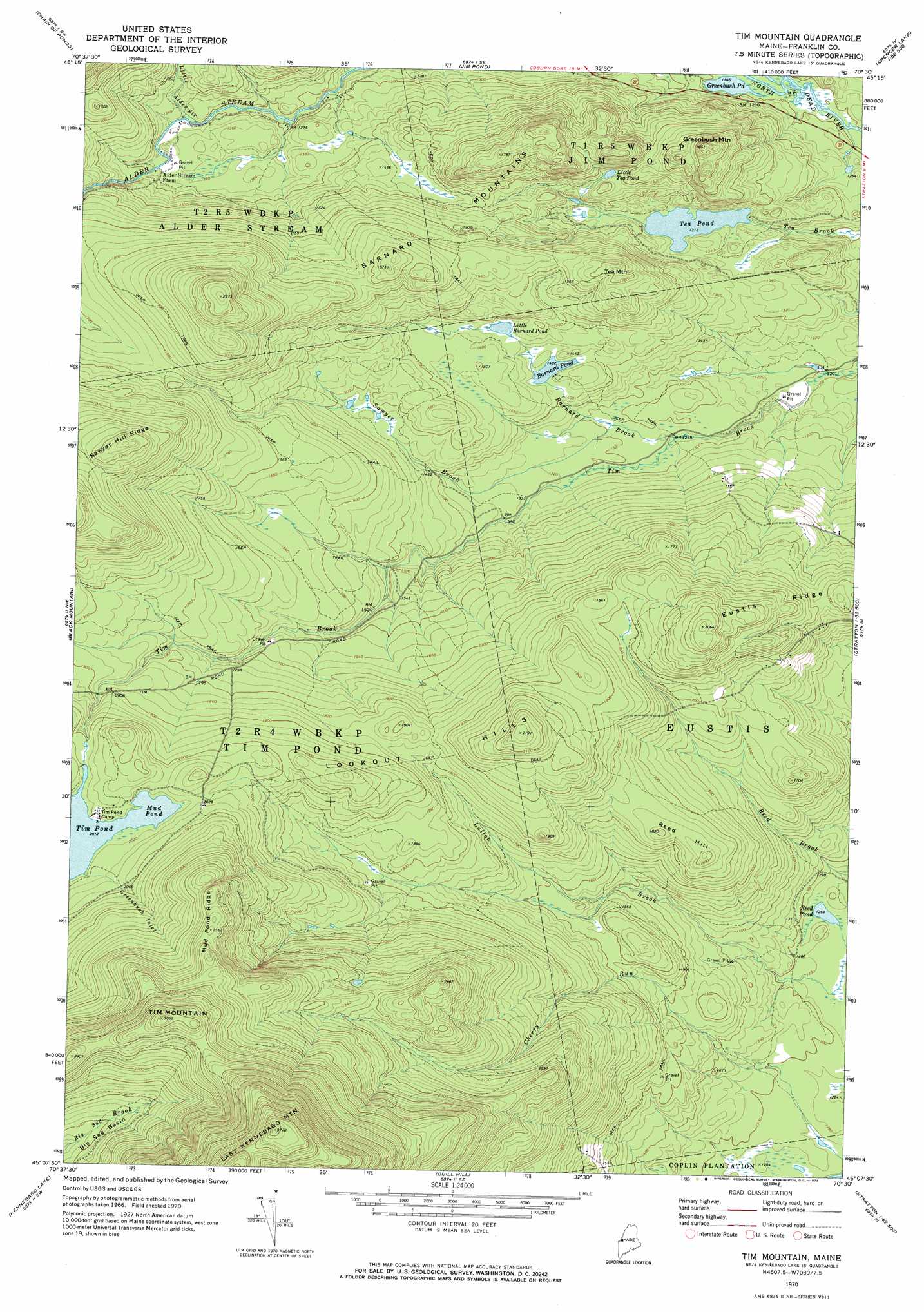
USGS Topo Quad 45070b5 - 1:24,000 scale
| Topo Map Name: | Tim Mountain |
| USGS Topo Quad ID: | 45070b5 |
| Print Size: | ca. 21 1/4" wide x 27" high |
| Southeast Coordinates: | 45.125° N latitude / 70.5° W longitude |
| Map Center Coordinates: | 45.1875° N latitude / 70.5625° W longitude |
| U.S. State: | ME |
| Filename: | o45070b5.jpg |
| Download Map JPG Image: | Tim Mountain topo map 1:24,000 scale |
| Map Type: | Topographic |
| Topo Series: | 7.5´ |
| Map Scale: | 1:24,000 |
| Source of Map Images: | United States Geological Survey (USGS) |
| Alternate Map Versions: |
Tim Mountain ME 1970, updated 1973 Download PDF Buy paper map Tim Mountain ME 1977, updated 1983 Download PDF Buy paper map Tim Mountain ME 2011 Download PDF Buy paper map Tim Mountain ME 2014 Download PDF Buy paper map |
1:24,000 Topo Quads surrounding Tim Mountain
Louise Mountain |
Merrill Mountain |
Kibby Mountain |
Tumbledown Mountain |
Spencer Lake |
Northwest Pond |
Chain Of Ponds |
Jim Pond |
King And Bartlett Mountain |
King And Bartlett Lake |
Little Kennebago Lake |
Black Mountain |
Tim Mountain |
Stratton |
The Horns |
Kennebago |
Kennebago Lake |
Quill Hill |
Black Nubble |
Sugarloaf Mountain |
Oquossoc |
Rangeley |
Saddleback Mountain |
Redington |
Mount Abraham |
> Back to 45070a1 at 1:100,000 scale
> Back to 45070a1 at 1:250,000 scale
> Back to U.S. Topo Maps home
Tim Mountain topo map: Gazetteer
Tim Mountain: Lakes
Barnard Pond elevation 432m 1417′Greenbush Pond elevation 361m 1184′
Little Barnard Pond elevation 441m 1446′
Little Tea Pond elevation 446m 1463′
Mud Pond elevation 613m 2011′
Reed Pond elevation 387m 1269′
Tea Pond elevation 400m 1312′
Tim Mountain: Reservoirs
Tim Pond elevation 613m 2011′Tim Mountain: Ridges
Mud Pond Ridge elevation 780m 2559′Sawyer Hill Ridge elevation 682m 2237′
Tim Mountain: Streams
Barnard Brook elevation 390m 1279′Greenbush Inlet elevation 616m 2020′
Little Alder Stream elevation 396m 1299′
Sawyer Brook elevation 395m 1295′
Tim Mountain: Summits
Barnard Mountains elevation 564m 1850′Greenbush Mountain elevation 556m 1824′
Lookout Hills elevation 640m 2099′
Reed Hill elevation 555m 1820′
Tea Mountain elevation 526m 1725′
Tim Mountain elevation 933m 3061′
Tim Mountain digital topo map on disk
Buy this Tim Mountain topo map showing relief, roads, GPS coordinates and other geographical features, as a high-resolution digital map file on DVD:
Maine, New Hampshire, Rhode Island & Eastern Massachusetts
Buy digital topo maps: Maine, New Hampshire, Rhode Island & Eastern Massachusetts