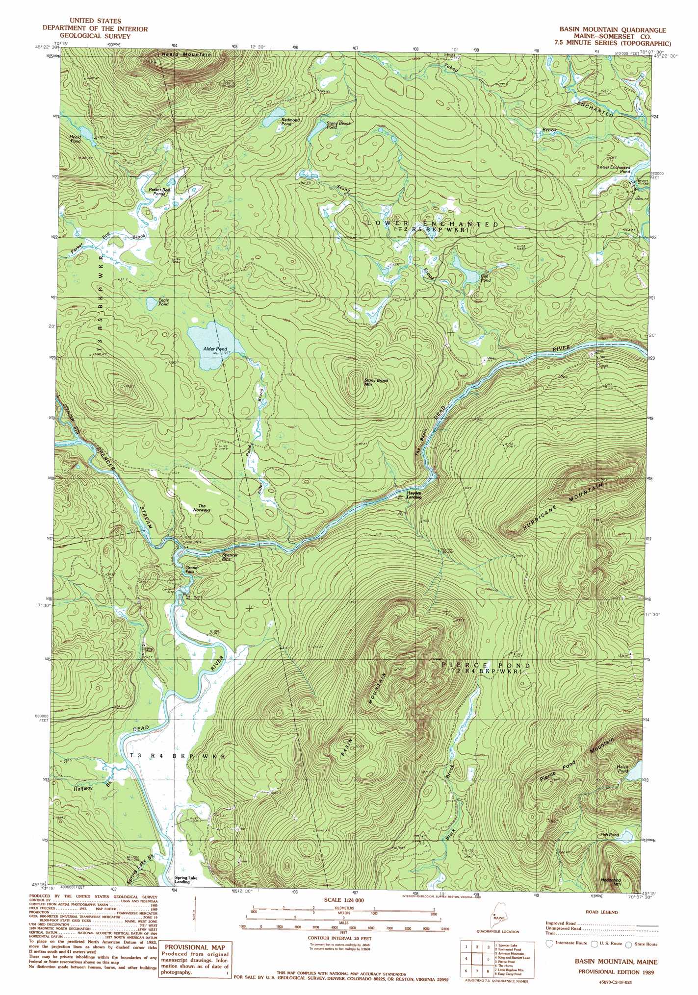
Basin Mountain Topo Map Maine
To zoom in, hover over the map of Basin Mountain
USGS Topo Quad 45070c2 - 1:24,000 scale
| Topo Map Name: | Basin Mountain |
| USGS Topo Quad ID: | 45070c2 |
| Print Size: | ca. 21 1/4" wide x 27" high |
| Southeast Coordinates: | 45.25° N latitude / 70.125° W longitude |
| Map Center Coordinates: | 45.3125° N latitude / 70.1875° W longitude |
| U.S. State: | ME |
| Filename: | o45070c2.jpg |
| Download Map JPG Image: | Basin Mountain topo map 1:24,000 scale |
| Map Type: | Topographic |
| Topo Series: | 7.5´ |
| Map Scale: | 1:24,000 |
| Source of Map Images: | United States Geological Survey (USGS) |
| Alternate Map Versions: |
Basin Mountain ME 1977, updated 1983 Download PDF Buy paper map Basin Mountain ME 1989, updated 1989 Download PDF Buy paper map Basin Mountain ME 2011 Download PDF Buy paper map Basin Mountain ME 2014 Download PDF Buy paper map |
1:24,000 Topo Quads surrounding Basin Mountain
Holeb |
Attean Pond |
Catheart Mountain |
Long Pond |
Misery Knob |
Tumbledown Mountain |
Spencer Lake |
Enchanted Pond |
Johnson Mountain |
Black Brook Pond |
King And Bartlett Mountain |
King And Bartlett Lake |
Basin Mountain |
Pierce Pond |
The Forks |
Stratton |
The Horns |
Little Bigelow Mountain |
East Carry Pond |
Caratunk |
Black Nubble |
Sugarloaf Mountain |
Poplar Mountain |
Witham Mountain |
Bingham |
> Back to 45070a1 at 1:100,000 scale
> Back to 45070a1 at 1:250,000 scale
> Back to U.S. Topo Maps home
Basin Mountain topo map: Gazetteer
Basin Mountain: Basins
The Basin elevation 277m 908′Basin Mountain: Dams
Dead River Dam (historical) elevation 312m 1023′Basin Mountain: Falls
Grand Falls elevation 305m 1000′Basin Mountain: Lakes
Alder Pond elevation 349m 1145′Call Pond elevation 297m 974′
Eagle Pond elevation 350m 1148′
Fish Pond elevation 468m 1535′
Heald Pond elevation 404m 1325′
Helen Pond elevation 624m 2047′
Parker Bog Ponds elevation 363m 1190′
Redmond Pond elevation 406m 1332′
Stony Brook Pond elevation 384m 1259′
Basin Mountain: Populated Places
Hayden Landing elevation 299m 980′Spring Lake Landing elevation 317m 1040′
Basin Mountain: Rapids
Spencer Rips elevation 315m 1033′Basin Mountain: Streams
Alder Pond Brook elevation 296m 971′Halfway Brook elevation 317m 1040′
Little Spencer Stream elevation 316m 1036′
Spencer Stream elevation 302m 990′
Spring Lake Brook elevation 317m 1040′
Stony Brook elevation 276m 905′
Tobey Brook elevation 329m 1079′
Basin Mountain: Summits
Basin Mountain elevation 716m 2349′Heald Mountain elevation 731m 2398′
Hedgehog Mountain elevation 590m 1935′
Hurricane Mountain elevation 616m 2020′
Stony Brook Mountain elevation 435m 1427′
The Norways elevation 337m 1105′
Basin Mountain digital topo map on disk
Buy this Basin Mountain topo map showing relief, roads, GPS coordinates and other geographical features, as a high-resolution digital map file on DVD:
Maine, New Hampshire, Rhode Island & Eastern Massachusetts
Buy digital topo maps: Maine, New Hampshire, Rhode Island & Eastern Massachusetts