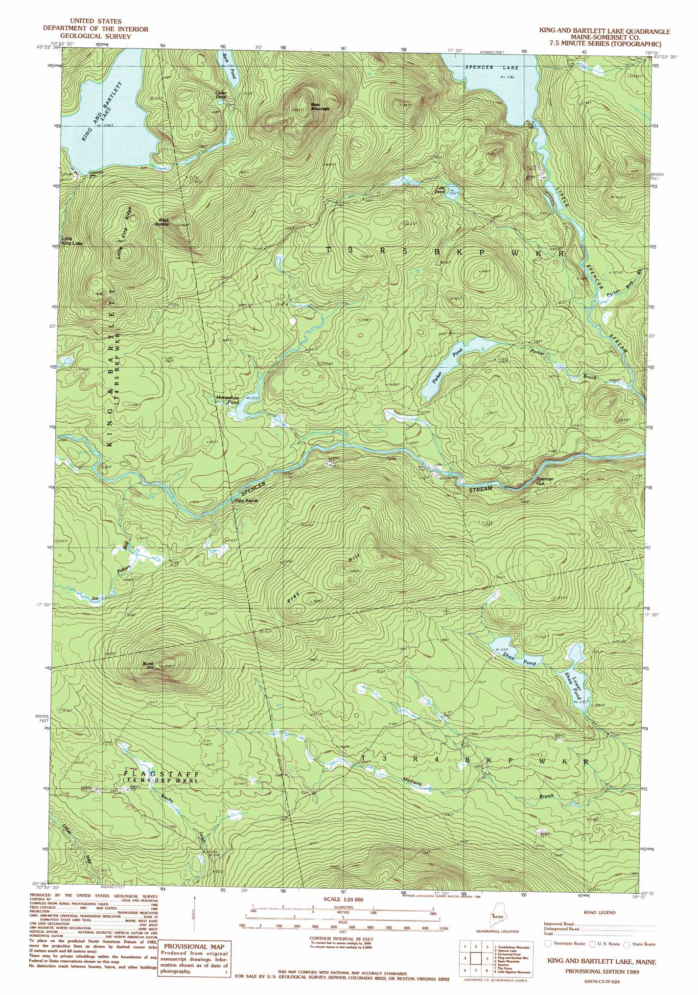
King And Bartlett Lake Topo Map Maine
To zoom in, hover over the map of King And Bartlett Lake
USGS Topo Quad 45070c3 - 1:24,000 scale
| Topo Map Name: | King And Bartlett Lake |
| USGS Topo Quad ID: | 45070c3 |
| Print Size: | ca. 21 1/4" wide x 27" high |
| Southeast Coordinates: | 45.25° N latitude / 70.25° W longitude |
| Map Center Coordinates: | 45.3125° N latitude / 70.3125° W longitude |
| U.S. State: | ME |
| Filename: | o45070c3.jpg |
| Download Map JPG Image: | King And Bartlett Lake topo map 1:24,000 scale |
| Map Type: | Topographic |
| Topo Series: | 7.5´ |
| Map Scale: | 1:24,000 |
| Source of Map Images: | United States Geological Survey (USGS) |
| Alternate Map Versions: |
King And Bartlett Lake ME 1977, updated 1983 Download PDF Buy paper map Kind And Bartlett Lake ME 1989, updated 1989 Download PDF Buy paper map King and Bartlett Lake ME 1989, updated 1989 Download PDF Buy paper map King And Bartlett Lake ME 2011 Download PDF Buy paper map King And Bartlett Lake ME 2014 Download PDF Buy paper map |
1:24,000 Topo Quads surrounding King And Bartlett Lake
Skinner |
Holeb |
Attean Pond |
Catheart Mountain |
Long Pond |
Kibby Mountain |
Tumbledown Mountain |
Spencer Lake |
Enchanted Pond |
Johnson Mountain |
Jim Pond |
King And Bartlett Mountain |
King And Bartlett Lake |
Basin Mountain |
Pierce Pond |
Tim Mountain |
Stratton |
The Horns |
Little Bigelow Mountain |
East Carry Pond |
Quill Hill |
Black Nubble |
Sugarloaf Mountain |
Poplar Mountain |
Witham Mountain |
> Back to 45070a1 at 1:100,000 scale
> Back to 45070a1 at 1:250,000 scale
> Back to U.S. Topo Maps home
King And Bartlett Lake topo map: Gazetteer
King And Bartlett Lake: Dams
King-Bartlett Lake Dam elevation 484m 1587′Spencer Lake Dam elevation 330m 1082′
King And Bartlett Lake: Guts
Spencer Gut elevation 329m 1079′King And Bartlett Lake: Lakes
Beck Pond elevation 529m 1735′Cedar Pond elevation 516m 1692′
Horseshoe Pond elevation 381m 1250′
Lost Pond elevation 386m 1266′
Lower Shaw Pond elevation 376m 1233′
Parker Pond elevation 362m 1187′
Shaw Pond elevation 388m 1272′
King And Bartlett Lake: Rapids
Gore Rapids elevation 374m 1227′King And Bartlett Lake: Reservoirs
King and Bartlett Lake elevation 484m 1587′Spencer Lake elevation 330m 1082′
King And Bartlett Lake: Ridges
Little King Ridge elevation 619m 2030′King And Bartlett Lake: Streams
Joe Pokum Bog elevation 386m 1266′Parker Bog Brook elevation 321m 1053′
Parker Brook elevation 317m 1040′
King And Bartlett Lake: Summits
Bear Mountain elevation 703m 2306′Black Nubble elevation 628m 2060′
Burnt Hill elevation 620m 2034′
Pray Hill elevation 571m 1873′
King And Bartlett Lake digital topo map on disk
Buy this King And Bartlett Lake topo map showing relief, roads, GPS coordinates and other geographical features, as a high-resolution digital map file on DVD:
Maine, New Hampshire, Rhode Island & Eastern Massachusetts
Buy digital topo maps: Maine, New Hampshire, Rhode Island & Eastern Massachusetts