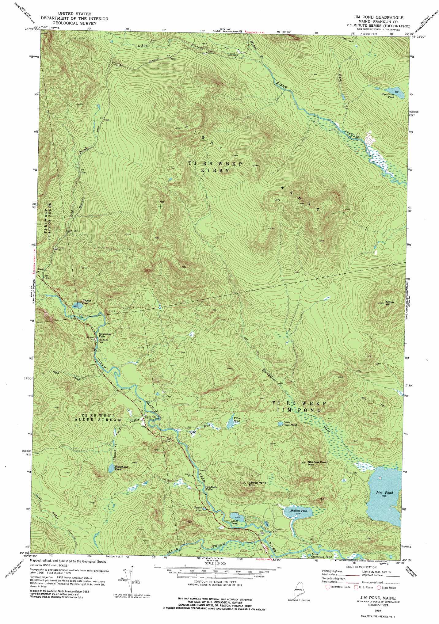
Jim Pond Topo Map Maine
To zoom in, hover over the map of Jim Pond
USGS Topo Quad 45070c5 - 1:24,000 scale
| Topo Map Name: | Jim Pond |
| USGS Topo Quad ID: | 45070c5 |
| Print Size: | ca. 21 1/4" wide x 27" high |
| Southeast Coordinates: | 45.25° N latitude / 70.5° W longitude |
| Map Center Coordinates: | 45.3125° N latitude / 70.5625° W longitude |
| U.S. State: | ME |
| Filename: | o45070c5.jpg |
| Download Map JPG Image: | Jim Pond topo map 1:24,000 scale |
| Map Type: | Topographic |
| Topo Series: | 7.5´ |
| Map Scale: | 1:24,000 |
| Source of Map Images: | United States Geological Survey (USGS) |
| Alternate Map Versions: |
Jim Pond ME 1969, updated 1973 Download PDF Buy paper map Jim Pond ME 1969, updated 1990 Download PDF Buy paper map Jim Pond ME 1977, updated 1983 Download PDF Buy paper map Jim Pond ME 2011 Download PDF Buy paper map Jim Pond ME 2014 Download PDF Buy paper map |
1:24,000 Topo Quads surrounding Jim Pond
Boundary Pond |
Skinner |
Holeb |
Attean Pond |
|
Louise Mountain |
Merrill Mountain |
Kibby Mountain |
Tumbledown Mountain |
Spencer Lake |
Northwest Pond |
Chain Of Ponds |
Jim Pond |
King And Bartlett Mountain |
King And Bartlett Lake |
Little Kennebago Lake |
Black Mountain |
Tim Mountain |
Stratton |
The Horns |
Kennebago |
Kennebago Lake |
Quill Hill |
Black Nubble |
Sugarloaf Mountain |
> Back to 45070a1 at 1:100,000 scale
> Back to 45070a1 at 1:250,000 scale
> Back to U.S. Topo Maps home
Jim Pond topo map: Gazetteer
Jim Pond: Falls
Sarampus Falls elevation 377m 1236′Shadagee Falls elevation 367m 1204′
Jim Pond: Lakes
Blanchard Pond elevation 411m 1348′Bugeye Pond elevation 393m 1289′
Chase Pond elevation 362m 1187′
Hurricane Pond elevation 626m 2053′
Jim Pond elevation 375m 1230′
Little Greenbush Pond elevation 366m 1200′
Little Viles Pond elevation 424m 1391′
Poison Pond elevation 365m 1197′
Shallow Pond elevation 364m 1194′
Viles Pond elevation 385m 1263′
Jim Pond: Ranges
Kibby Range elevation 848m 2782′Jim Pond: Streams
Alder Stream elevation 364m 1194′Blanchard Pond Outlet elevation 377m 1236′
East Branch Kibby Stream elevation 489m 1604′
Gold Brook elevation 390m 1279′
Middle Branch Kibby Stream elevation 534m 1751′
Nash Brook elevation 376m 1233′
Northwest Inlet elevation 375m 1230′
Shadagee Brook elevation 367m 1204′
Viles Brook elevation 369m 1210′
Jim Pond: Summits
Antler Hill elevation 805m 2641′Chase Pond Mountain elevation 554m 1817′
Shallow Pond Mountain elevation 574m 1883′
Jim Pond digital topo map on disk
Buy this Jim Pond topo map showing relief, roads, GPS coordinates and other geographical features, as a high-resolution digital map file on DVD:
Maine, New Hampshire, Rhode Island & Eastern Massachusetts
Buy digital topo maps: Maine, New Hampshire, Rhode Island & Eastern Massachusetts