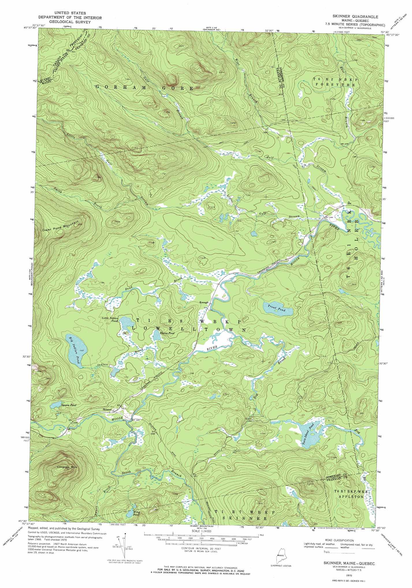
Skinner Topo Map Maine
To zoom in, hover over the map of Skinner
USGS Topo Quad 45070e5 - 1:24,000 scale
| Topo Map Name: | Skinner |
| USGS Topo Quad ID: | 45070e5 |
| Print Size: | ca. 21 1/4" wide x 27" high |
| Southeast Coordinates: | 45.5° N latitude / 70.5° W longitude |
| Map Center Coordinates: | 45.5625° N latitude / 70.5625° W longitude |
| U.S. State: | ME |
| Filename: | o45070e5.jpg |
| Download Map JPG Image: | Skinner topo map 1:24,000 scale |
| Map Type: | Topographic |
| Topo Series: | 7.5´ |
| Map Scale: | 1:24,000 |
| Source of Map Images: | United States Geological Survey (USGS) |
| Alternate Map Versions: |
Skinner ME 1970, updated 1973 Download PDF Buy paper map Skinner ME 1970, updated 1984 Download PDF Buy paper map Skinner ME 1977, updated 1983 Download PDF Buy paper map Skinner ME 2011 Download PDF Buy paper map Skinner ME 2014 Download PDF Buy paper map |
1:24,000 Topo Quads surrounding Skinner
Sandy Bay Mountain |
Campbell Brook |
|||
Skinner Ne |
Stony Brook |
Jackman |
||
Boundary Pond |
Skinner |
Holeb |
Attean Pond |
|
Louise Mountain |
Merrill Mountain |
Kibby Mountain |
Tumbledown Mountain |
Spencer Lake |
Northwest Pond |
Chain Of Ponds |
Jim Pond |
King And Bartlett Mountain |
King And Bartlett Lake |
> Back to 45070e1 at 1:100,000 scale
> Back to 45070a1 at 1:250,000 scale
> Back to U.S. Topo Maps home
Skinner topo map: Gazetteer
Skinner: Lakes
Elaine Pond elevation 419m 1374′Oqim Pond elevation 438m 1437′
Sapet Pond elevation 425m 1394′
Sipun Pond elevation 467m 1532′
Trout Pond elevation 412m 1351′
Twin Island Pond elevation 440m 1443′
Wing Pond elevation 521m 1709′
Skinner: Populated Places
Keough elevation 404m 1325′Skinner elevation 437m 1433′
Skinner: Streams
Bog Brook elevation 401m 1315′Dead Brook elevation 403m 1322′
East Branch Gulf Stream elevation 386m 1266′
Gulf Stream elevation 382m 1253′
Indian Brook elevation 410m 1345′
Little Gulf Stream elevation 383m 1256′
Smart Brook elevation 438m 1437′
Smith Brook elevation 421m 1381′
South Branch Moose River elevation 426m 1397′
West Branch Gulf Stream elevation 389m 1276′
Skinner: Summits
Caswell Mountain elevation 706m 2316′Skinner digital topo map on disk
Buy this Skinner topo map showing relief, roads, GPS coordinates and other geographical features, as a high-resolution digital map file on DVD:
Maine, New Hampshire, Rhode Island & Eastern Massachusetts
Buy digital topo maps: Maine, New Hampshire, Rhode Island & Eastern Massachusetts