Jackman Topo Map Maine
To zoom in, hover over the map of Jackman
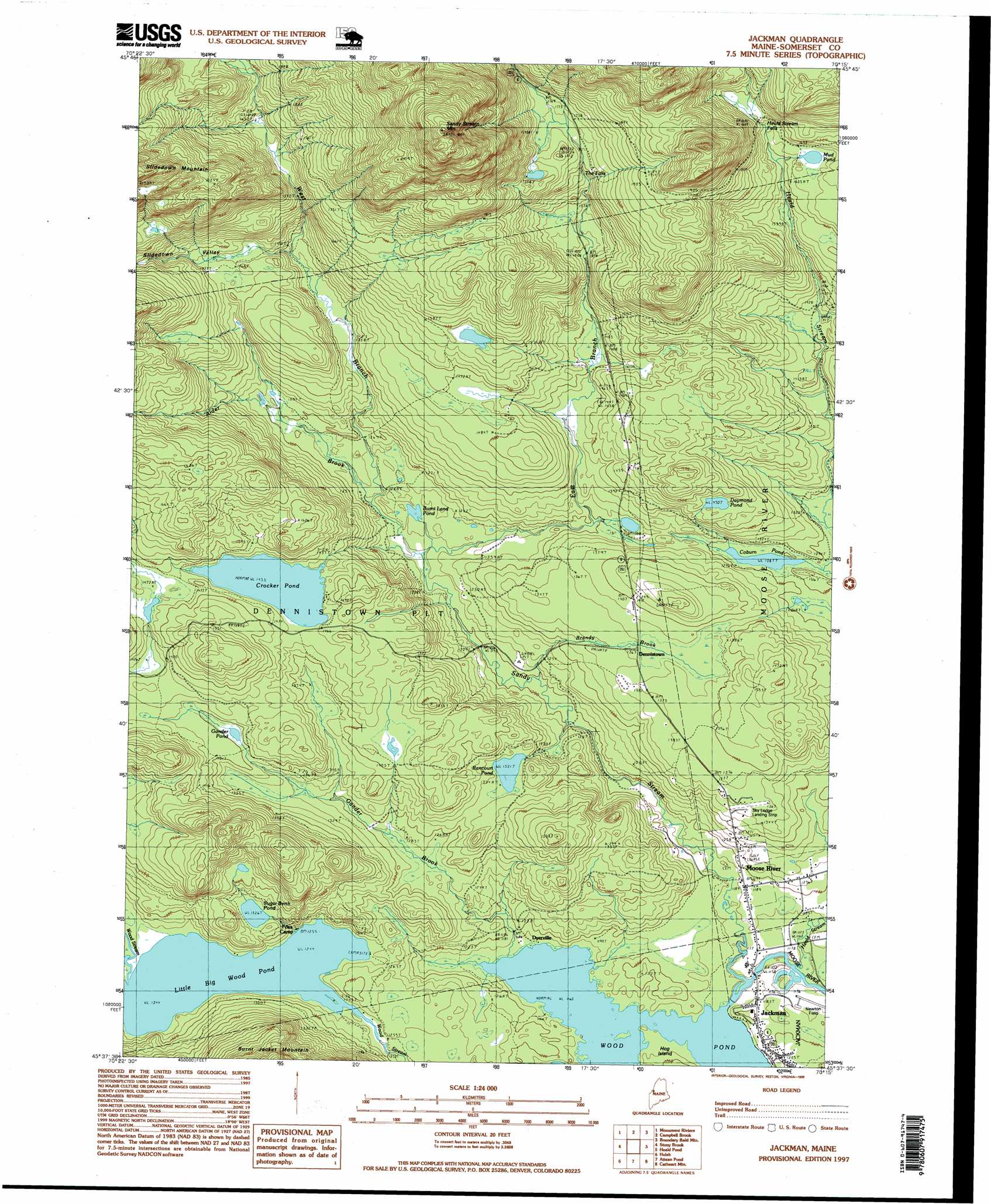
USGS Topo Quad 45070f3 - 1:24,000 scale
| Topo Map Name: | Jackman |
| USGS Topo Quad ID: | 45070f3 |
| Print Size: | ca. 21 1/4" wide x 27" high |
| Southeast Coordinates: | 45.625° N latitude / 70.25° W longitude |
| Map Center Coordinates: | 45.6875° N latitude / 70.3125° W longitude |
| U.S. State: | ME |
| Filename: | o45070f3.jpg |
| Download Map JPG Image: | Jackman topo map 1:24,000 scale |
| Map Type: | Topographic |
| Topo Series: | 7.5´ |
| Map Scale: | 1:24,000 |
| Source of Map Images: | United States Geological Survey (USGS) |
| Alternate Map Versions: |
Jackman ME 1977, updated 1983 Download PDF Buy paper map Jackman ME 1989, updated 1989 Download PDF Buy paper map Jackman ME 1997, updated 1999 Download PDF Buy paper map Jackman ME 2011 Download PDF Buy paper map Jackman ME 2014 Download PDF Buy paper map |
1:24,000 Topo Quads surrounding Jackman
Lac Portage |
Penobscot Lake |
Foley Pond |
||
Sandy Bay Mountain |
Campbell Brook |
Boundary Bald Mountain |
Canada Falls Lake |
|
Skinner Ne |
Stony Brook |
Jackman |
Heald Pond |
Churchill Stream |
Skinner |
Holeb |
Attean Pond |
Catheart Mountain |
Long Pond |
Kibby Mountain |
Tumbledown Mountain |
Spencer Lake |
Enchanted Pond |
Johnson Mountain |
> Back to 45070e1 at 1:100,000 scale
> Back to 45070a1 at 1:250,000 scale
> Back to U.S. Topo Maps home
Jackman topo map: Gazetteer
Jackman: Airports
Moose River Seaplane Base elevation 354m 1161′Sky Lodge Landing Strip elevation 415m 1361′
Jackman: Dams
Crocker Pond Dam elevation 442m 1450′Jackman: Falls
Heald Stream Falls elevation 510m 1673′The Falls elevation 480m 1574′
Jackman: Islands
Hog Island elevation 358m 1174′Jackman: Lakes
Burnt Land Pond elevation 382m 1253′Coburn Pond elevation 392m 1286′
Crocker Pond elevation 443m 1453′
Daymond Pond elevation 442m 1450′
Gander Pond elevation 429m 1407′
Little Big Wood Pond elevation 379m 1243′
Mud Pond elevation 497m 1630′
Rancourt Pond elevation 402m 1318′
Sugar Berth Pond elevation 404m 1325′
Jackman: Populated Places
Dennistown elevation 416m 1364′Dyerville elevation 364m 1194′
Moose River elevation 376m 1233′
Jackman: Reservoirs
Crocker Pond elevation 442m 1450′Jackman: Streams
Alder Brook elevation 390m 1279′Brandy Brook elevation 367m 1204′
East Branch Sandy Stream elevation 381m 1250′
Gander Brook elevation 355m 1164′
Heald Stream elevation 363m 1190′
West Branch Sandy Stream elevation 381m 1250′
Jackman: Summits
Sandy Stream Mountain elevation 830m 2723′Slidedown Mountain elevation 739m 2424′
Jackman: Valleys
Slidedown Valley elevation 452m 1482′Jackman digital topo map on disk
Buy this Jackman topo map showing relief, roads, GPS coordinates and other geographical features, as a high-resolution digital map file on DVD:
Maine, New Hampshire, Rhode Island & Eastern Massachusetts
Buy digital topo maps: Maine, New Hampshire, Rhode Island & Eastern Massachusetts