Cowen Hill Topo Map New Hampshire
To zoom in, hover over the map of Cowen Hill
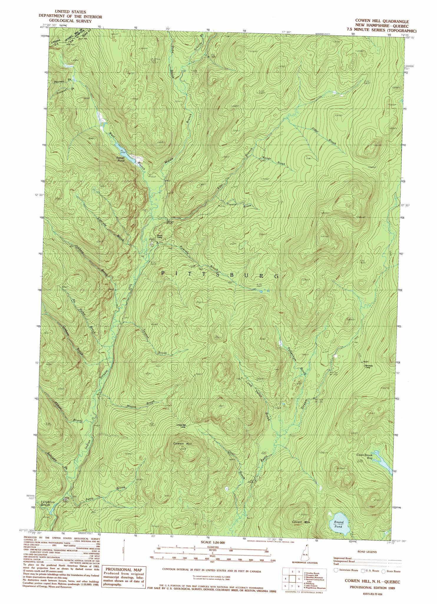
USGS Topo Quad 45071b3 - 1:24,000 scale
| Topo Map Name: | Cowen Hill |
| USGS Topo Quad ID: | 45071b3 |
| Print Size: | ca. 21 1/4" wide x 27" high |
| Southeast Coordinates: | 45.125° N latitude / 71.25° W longitude |
| Map Center Coordinates: | 45.1875° N latitude / 71.3125° W longitude |
| U.S. State: | NH |
| Filename: | o45071b3.jpg |
| Download Map JPG Image: | Cowen Hill topo map 1:24,000 scale |
| Map Type: | Topographic |
| Topo Series: | 7.5´ |
| Map Scale: | 1:24,000 |
| Source of Map Images: | United States Geological Survey (USGS) |
| Alternate Map Versions: |
Cowen Hill NH 1989, updated 1989 Download PDF Buy paper map Cowen Hill NH 2012 Download PDF Buy paper map Cowen Hill NH 2015 Download PDF Buy paper map |
1:24,000 Topo Quads surrounding Cowen Hill
Bellefeuille |
Chartierville |
Moose Bog |
||
Malvina |
Cowen Hill |
Second Connecticut Lake |
Rump Mountain |
|
Pittsburg |
Lake Francis |
Magalloway Mountain |
Bosebuck Mountain |
|
Monadnock Mountain |
Lovering Mountain |
Diamond Pond |
Mount Pisgah |
Wilsons Mills |
> Back to 45071a1 at 1:100,000 scale
> Back to 45070a1 at 1:250,000 scale
> Back to U.S. Topo Maps home
Cowen Hill topo map: Gazetteer
Cowen Hill: Dams
Pearley Terrill Dam elevation 465m 1525′Cowen Hill: Lakes
Round Pond elevation 583m 1912′Terrell Pond elevation 439m 1440′
Cowen Hill: Reservoirs
West Branch of Indian Stream Reservoir elevation 465m 1525′Cowen Hill: Streams
Abbott Brook elevation 426m 1397′Alder Brook elevation 597m 1958′
Cascade Brook elevation 460m 1509′
Day Brook elevation 559m 1833′
Dube Brook elevation 462m 1515′
East Branch Indian Stream elevation 443m 1453′
Falkenham Brook elevation 535m 1755′
Graham Brook elevation 439m 1440′
Greeley Brook elevation 463m 1519′
Jobbers Brook elevation 431m 1414′
Lamb Valley Brook elevation 520m 1706′
Leighton Brook elevation 429m 1407′
Middle Branch Indian Stream elevation 437m 1433′
Moose Brook elevation 440m 1443′
No Name Brook elevation 423m 1387′
Otter Brook elevation 490m 1607′
Perry Brook elevation 415m 1361′
Peterson Brook elevation 466m 1528′
Roaring Brook elevation 436m 1430′
Runcourt Brook elevation 466m 1528′
Schoppe Brook elevation 451m 1479′
Teapot Brook elevation 436m 1430′
Trestle Brook elevation 517m 1696′
West Branch Indian Stream elevation 437m 1433′
Woods Brook elevation 559m 1833′
Cowen Hill: Summits
Covell Mountain elevation 716m 2349′Cowen Hill elevation 739m 2424′
Cowen Hill: Swamps
Coon Brook Bog elevation 600m 1968′Cowen Hill: Valleys
Lamb Valley elevation 519m 1702′Cowen Hill digital topo map on disk
Buy this Cowen Hill topo map showing relief, roads, GPS coordinates and other geographical features, as a high-resolution digital map file on DVD:
Maine, New Hampshire, Rhode Island & Eastern Massachusetts
Buy digital topo maps: Maine, New Hampshire, Rhode Island & Eastern Massachusetts