Petoskey Topo Map Michigan
To zoom in, hover over the map of Petoskey
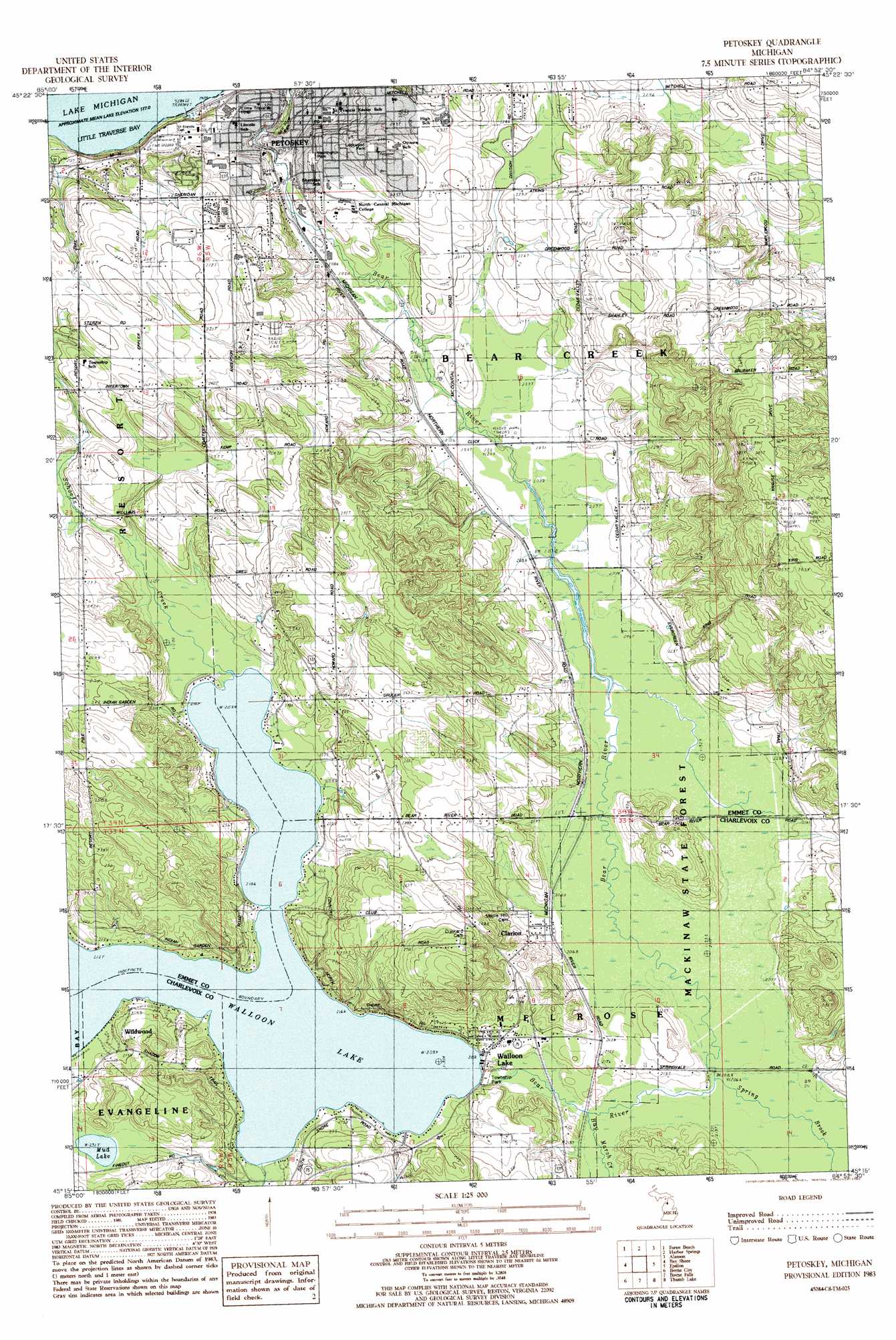
USGS Topo Quad 45084c8 - 1:25,000 scale
| Topo Map Name: | Petoskey |
| USGS Topo Quad ID: | 45084c8 |
| Print Size: | ca. 21 1/4" wide x 27" high |
| Southeast Coordinates: | 45.25° N latitude / 84.875° W longitude |
| Map Center Coordinates: | 45.3125° N latitude / 84.9375° W longitude |
| U.S. State: | MI |
| Filename: | l45084c8.jpg |
| Download Map JPG Image: | Petoskey topo map 1:25,000 scale |
| Map Type: | Topographic |
| Topo Series: | 7.5´ |
| Map Scale: | 1:25,000 |
| Source of Map Images: | United States Geological Survey (USGS) |
| Alternate Map Versions: |
Petoskey MI 1983, updated 1984 Download PDF Buy paper map |
1:24,000 Topo Quads surrounding Petoskey
Goodhart |
Larks Lake |
Pellston |
Indian Village |
|
Forest Beach |
Harbor Springs |
Alanson |
Burt Lake |
|
Ironton |
Bayshore |
Petoskey |
Epsilon |
Wildwood |
Ellsworth |
Boyne City |
Boyne Falls |
Thumb Lake |
Vanderbilt |
Scotts Lake |
Chestonia |
Deadmans Hill |
Elmira |
Gaylord |
> Back to 45084a1 at 1:100,000 scale
> Back to 45084a1 at 1:250,000 scale
> Back to U.S. Topo Maps home
Petoskey topo map: Gazetteer
Petoskey: Airports
North Michigan Hospitals Incorporated Heliport elevation 278m 912′Petoskey: Lakes
Mud Lake elevation 231m 757′Petoskey: Parks
Bear River Park elevation 207m 679′Curtis Park elevation 202m 662′
East Park elevation 188m 616′
Lockwood Park elevation 251m 823′
Magnus Park elevation 182m 597′
Melrose Township Park elevation 211m 692′
River Road Sports Complex elevation 206m 675′
Washington Park elevation 222m 728′
Petoskey: Populated Places
Clarion elevation 214m 702′Lake Michigan Heights Mobile Home Park elevation 245m 803′
Petoskey elevation 203m 666′
Radio City Village Mobile Home Park elevation 275m 902′
Walloon Lake elevation 217m 711′
Petoskey: Post Offices
Clarion Post Office (historical) elevation 214m 702′Petoskey Post Office elevation 208m 682′
Walloon Lake Post Office elevation 223m 731′
Petoskey: Streams
Hay Marsh Creek elevation 207m 679′Schoofs Creek elevation 209m 685′
Spring Brook elevation 207m 679′
Petoskey digital topo map on disk
Buy this Petoskey topo map showing relief, roads, GPS coordinates and other geographical features, as a high-resolution digital map file on DVD: