Round Island Topo Map Michigan
To zoom in, hover over the map of Round Island
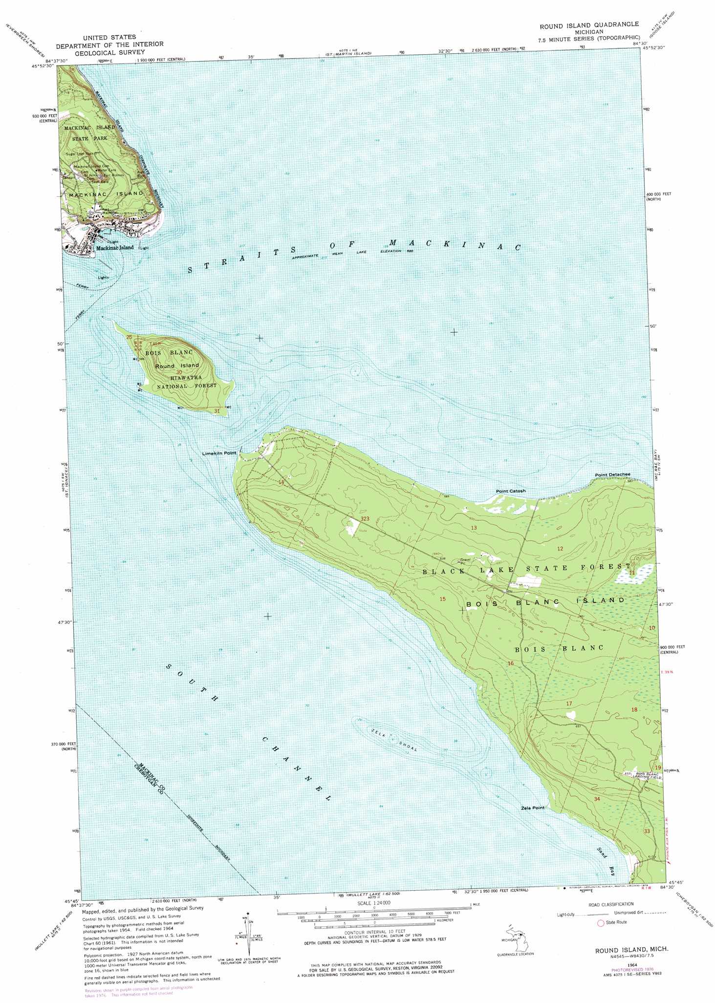
USGS Topo Quad 45084g5 - 1:24,000 scale
| Topo Map Name: | Round Island |
| USGS Topo Quad ID: | 45084g5 |
| Print Size: | ca. 21 1/4" wide x 27" high |
| Southeast Coordinates: | 45.75° N latitude / 84.5° W longitude |
| Map Center Coordinates: | 45.8125° N latitude / 84.5625° W longitude |
| U.S. State: | MI |
| Filename: | o45084g5.jpg |
| Download Map JPG Image: | Round Island topo map 1:24,000 scale |
| Map Type: | Topographic |
| Topo Series: | 7.5´ |
| Map Scale: | 1:24,000 |
| Source of Map Images: | United States Geological Survey (USGS) |
| Alternate Map Versions: |
Round Island MI 1964, updated 1966 Download PDF Buy paper map Round Island MI 1964, updated 1978 Download PDF Buy paper map Round Island MI 2011 Download PDF Buy paper map Round Island MI 2014 Download PDF Buy paper map Round Island MI 2017 Download PDF Buy paper map |
| FStopo: | US Forest Service topo Round Island is available: Download FStopo PDF Download FStopo TIF |
1:24,000 Topo Quads surrounding Round Island
Ozark Se |
Charles |
Pontchartrain Shores |
Hessel |
Pickford Se |
Moran |
Evergreen Shores |
Saint Martin Island |
Goose Island |
Cedarville |
Mcgulpin Point |
Saint Ignace |
Round Island |
Mcrae Bay |
|
Levaring |
Freedom |
Point Nipigon |
Cheboygan |
Cordwood Point |
Pellston |
Indian Village |
Mullett Lake |
Aloha |
Manning |
> Back to 45084e1 at 1:100,000 scale
> Back to 45084a1 at 1:250,000 scale
> Back to U.S. Topo Maps home
Round Island topo map: Gazetteer
Round Island: Airports
Bois Blanc Airport elevation 197m 646′Round Island: Arches
Arch Rock elevation 217m 711′Round Island: Bars
Zela Shoal elevation 177m 580′Round Island: Bays
Haldimand Bay elevation 177m 580′Sand Bay elevation 177m 580′
Voyageurs Bay elevation 177m 580′
Round Island: Capes
Biddle Point elevation 177m 580′Hennepin Point elevation 185m 606′
Julia Point elevation 178m 583′
Lime Kiln Point elevation 177m 580′
Mission Point elevation 178m 583′
Mission Point elevation 177m 580′
Point Catosh elevation 177m 580′
Point Detache elevation 178m 583′
Windermere Point elevation 177m 580′
Zela Point elevation 177m 580′
Round Island: Islands
Round Island elevation 206m 675′Round Island: Lakes
Carver Pond elevation 178m 583′Hanks Pond elevation 185m 606′
Round Island: Parks
American Fur Company Store Historical Marker elevation 183m 600′Beaumont Memorial Historical Marker elevation 186m 610′
British Cannon Historical Marker elevation 273m 895′
Early Missionary Bark Chapel Historical Marker (historical) elevation 183m 600′
Fort Holmes Historical Marker elevation 273m 895′
Great Turtle Park elevation 242m 793′
Historic Fort Mackinac Historical Marker elevation 223m 731′
Indian Dormitory Historical Marker (historical) elevation 180m 590′
Island House Historical Marker elevation 179m 587′
Lake View Hotel Historical Marker elevation 177m 580′
Little Stone Church Historical Marker elevation 187m 613′
Mackinac Conference Historical Marker elevation 196m 643′
Mackinac Island Historical Marker elevation 181m 593′
Mackiniac Island City Park elevation 181m 593′
Market Street Historical Marker elevation 181m 593′
Marquette Park elevation 186m 610′
Mission Church Historical Marker elevation 179m 587′
Mission House Historical Marker elevation 184m 603′
Old Agency House Historical Marker (historical) elevation 179m 587′
Round Island Lighthouse Historical Marker elevation 178m 583′
Saint Anne Church Historical Marker elevation 180m 590′
Skull Cave Historical Marker elevation 241m 790′
Trinity Church Historical Marker elevation 185m 606′
Round Island: Pillars
Sugar Loaf Rock elevation 236m 774′Round Island: Populated Places
Fort Holmes elevation 273m 895′Fort Mackinac elevation 225m 738′
Mackinac Island elevation 181m 593′
Round Island: Post Offices
Mackinac Island Post Office elevation 177m 580′Point Catosh Post Office (historical) elevation 177m 580′
Sand Bay Post Office (historical) elevation 183m 600′
Round Island digital topo map on disk
Buy this Round Island topo map showing relief, roads, GPS coordinates and other geographical features, as a high-resolution digital map file on DVD: