Boyne City Topo Map Michigan
To zoom in, hover over the map of Boyne City
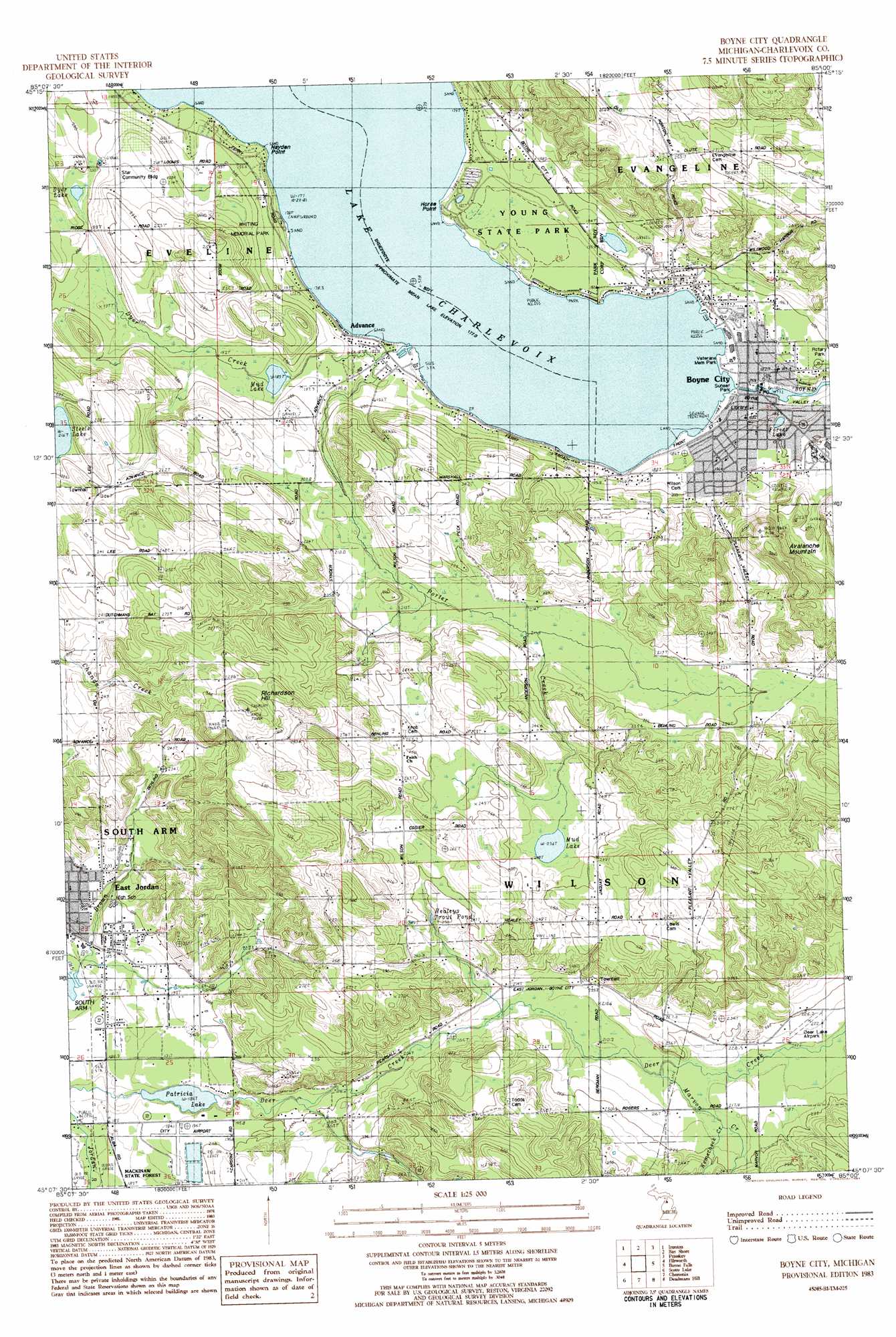
USGS Topo Quad 45085b1 - 1:25,000 scale
| Topo Map Name: | Boyne City |
| USGS Topo Quad ID: | 45085b1 |
| Print Size: | ca. 21 1/4" wide x 27" high |
| Southeast Coordinates: | 45.125° N latitude / 85° W longitude |
| Map Center Coordinates: | 45.1875° N latitude / 85.0625° W longitude |
| U.S. State: | MI |
| Filename: | l45085b1.jpg |
| Download Map JPG Image: | Boyne City topo map 1:25,000 scale |
| Map Type: | Topographic |
| Topo Series: | 7.5´ |
| Map Scale: | 1:25,000 |
| Source of Map Images: | United States Geological Survey (USGS) |
| Alternate Map Versions: |
1:24,000 Topo Quads surrounding Boyne City
Forest Beach |
Harbor Springs |
Alanson |
||
Charlevoix |
Ironton |
Bayshore |
Petoskey |
Epsilon |
Atwood |
Ellsworth |
Boyne City |
Boyne Falls |
Thumb Lake |
Central Lake |
Scotts Lake |
Chestonia |
Deadmans Hill |
Elmira |
Alden |
Bellaire |
Mancelona |
Alba |
Lake Arrowhead |
> Back to 45085a1 at 1:100,000 scale
> Back to 45084a1 at 1:250,000 scale
> Back to U.S. Topo Maps home
Boyne City topo map: Gazetteer
Boyne City: Airports
Deer Lake Airpark elevation 222m 728′East Jordan City Airport elevation 191m 626′
Wilson Township Airport elevation 221m 725′
Boyne City: Bridges
Rogers Bridge elevation 179m 587′Boyne City: Capes
Hayden Point elevation 183m 600′Horse Point elevation 177m 580′
Boyne City: Lakes
Dyer Lake elevation 197m 646′Forest Lake elevation 182m 597′
Mud Lake elevation 188m 616′
Mud Lake elevation 236m 774′
Patricia Lake elevation 184m 603′
Boyne City: Parks
Boswell Stadium elevation 201m 659′Boyne City United Methodist Church Historical Marker elevation 186m 610′
Community Park elevation 185m 606′
East Jordan Rotary Skate Park elevation 179m 587′
Riverside Park elevation 179m 587′
Rotary Park elevation 198m 649′
Sunset Park elevation 178m 583′
Tannery Park elevation 180m 590′
Veterans Memorial Park elevation 179m 587′
Whiting Park elevation 209m 685′
Young State Park elevation 181m 593′
Boyne City: Populated Places
Advance elevation 179m 587′Boyne City elevation 181m 593′
East Jordan elevation 197m 646′
East Jordan Mobile Home Park elevation 188m 616′
Lakeview Mobile Home Village elevation 185m 606′
Boyne City: Post Offices
Advance Post Office (historical) elevation 179m 587′Baysprings Post Office (historical) elevation 198m 649′
Boyne City Post Office elevation 180m 590′
Sedan Post Office (historical) elevation 232m 761′
Boyne City: Reservoirs
Healeys Trout Pond elevation 241m 790′Boyne City: Streams
Boyne River elevation 179m 587′Dyer Creek elevation 184m 603′
Marvon Creek elevation 211m 692′
Porter Creek elevation 180m 590′
Boyne City: Summits
Avalanche Mountain elevation 293m 961′Richardson Hill elevation 331m 1085′
Boyne City digital topo map on disk
Buy this Boyne City topo map showing relief, roads, GPS coordinates and other geographical features, as a high-resolution digital map file on DVD: