Ellsworth Topo Map Michigan
To zoom in, hover over the map of Ellsworth
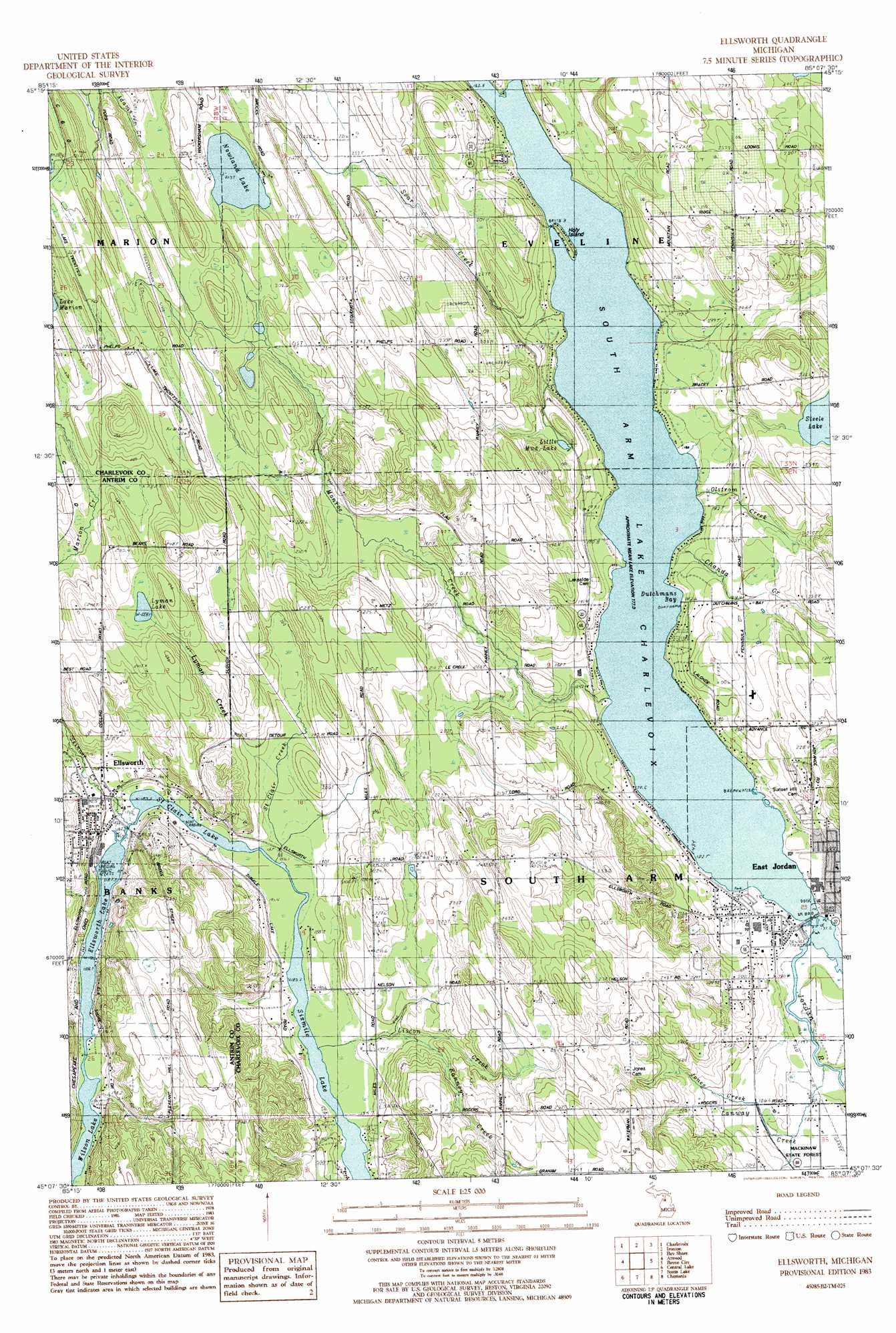
USGS Topo Quad 45085b2 - 1:25,000 scale
| Topo Map Name: | Ellsworth |
| USGS Topo Quad ID: | 45085b2 |
| Print Size: | ca. 21 1/4" wide x 27" high |
| Southeast Coordinates: | 45.125° N latitude / 85.125° W longitude |
| Map Center Coordinates: | 45.1875° N latitude / 85.1875° W longitude |
| U.S. State: | MI |
| Filename: | l45085b2.jpg |
| Download Map JPG Image: | Ellsworth topo map 1:25,000 scale |
| Map Type: | Topographic |
| Topo Series: | 7.5´ |
| Map Scale: | 1:25,000 |
| Source of Map Images: | United States Geological Survey (USGS) |
| Alternate Map Versions: |
Ellsworth MI 1983, updated 1984 Download PDF Buy paper map |
1:24,000 Topo Quads surrounding Ellsworth
Forest Beach |
Harbor Springs |
|||
Charlevoix |
Ironton |
Bayshore |
Petoskey |
|
Atwood |
Ellsworth |
Boyne City |
Boyne Falls |
|
Central Lake |
Scotts Lake |
Chestonia |
Deadmans Hill |
|
Elk Rapids |
Alden |
Bellaire |
Mancelona |
Alba |
> Back to 45085a1 at 1:100,000 scale
> Back to 45084a1 at 1:250,000 scale
> Back to U.S. Topo Maps home
Ellsworth topo map: Gazetteer
Ellsworth: Bays
Dutchmans Bay elevation 177m 580′South Arm elevation 177m 580′
Ellsworth: Islands
Holy Island elevation 177m 580′Ellsworth: Lakes
Ellsworth Lake elevation 185m 606′Little Mud Lake elevation 202m 662′
Lymans Lake elevation 226m 741′
Nowland Lake elevation 213m 698′
Saint Clair Lake elevation 185m 606′
Steele Lake elevation 216m 708′
Wilson Lake elevation 185m 606′
Ellsworth: Parks
Ellsworth Sports Park elevation 196m 643′Elm Pointe Park elevation 183m 600′
John and Eva Porter Estate Historical Marker elevation 183m 600′
Memorial Park elevation 180m 590′
Murphy Field elevation 179m 587′
Sportsman's Park elevation 179m 587′
Tourist Park elevation 179m 587′
Wooden Shoe Park elevation 188m 616′
Ellsworth: Populated Places
Ellsworth elevation 201m 659′Ellsworth: Post Offices
Dwight Post Office (historical) elevation 185m 606′East Jordan Post Office elevation 189m 620′
Ellsworth Post Office elevation 200m 656′
Intermediate Post Office (historical) elevation 208m 682′
Rock Elm Post Office (historical) elevation 210m 688′
South Arm Post Office (historical) elevation 201m 659′
Ellsworth: Streams
Black Kettle Creek elevation 205m 672′Brown Creek elevation 178m 583′
Chanda Creek elevation 177m 580′
Deer Creek elevation 178m 583′
Jones Creek elevation 178m 583′
Jordan River elevation 178m 583′
Liscon Creek elevation 185m 606′
Lyman Creek elevation 192m 629′
Marion Creek elevation 213m 698′
Monroe Creek elevation 178m 583′
Ranney Creek elevation 187m 613′
Saint Clair Creek elevation 186m 610′
Sear Creek elevation 178m 583′
Skinner Creek elevation 187m 613′
Ellsworth digital topo map on disk
Buy this Ellsworth topo map showing relief, roads, GPS coordinates and other geographical features, as a high-resolution digital map file on DVD: