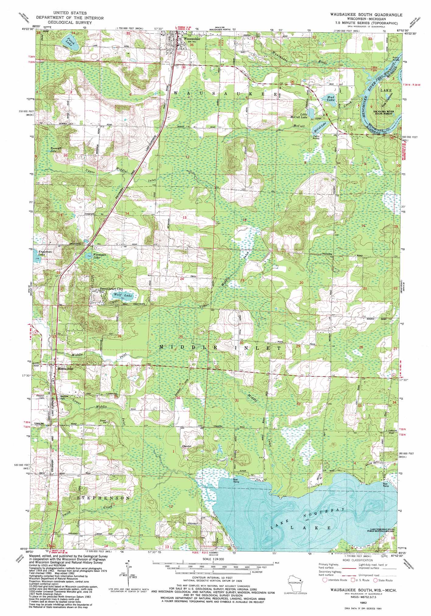
Wausaukee South Topo Map Wisconsin
To zoom in, hover over the map of Wausaukee South
USGS Topo Quad 45087c8 - 1:24,000 scale
| Topo Map Name: | Wausaukee South |
| USGS Topo Quad ID: | 45087c8 |
| Print Size: | ca. 21 1/4" wide x 27" high |
| Southeast Coordinates: | 45.25° N latitude / 87.875° W longitude |
| Map Center Coordinates: | 45.3125° N latitude / 87.9375° W longitude |
| U.S. States: | WI, MI |
| Filename: | o45087c8.jpg |
| Download Map JPG Image: | Wausaukee South topo map 1:24,000 scale |
| Map Type: | Topographic |
| Topo Series: | 7.5´ |
| Map Scale: | 1:24,000 |
| Source of Map Images: | United States Geological Survey (USGS) |
| Alternate Map Versions: |
Wausaukee South WI 1982, updated 1983 Download PDF Buy paper map Wausaukee South WI 2011 Download PDF Buy paper map Wausaukee South WI 2013 Download PDF Buy paper map Wausaukee South WI 2016 Download PDF Buy paper map |
1:24,000 Topo Quads surrounding Wausaukee South
Twelvefoot Falls |
Town Corner Lake |
Amberg |
Miscauno Island |
Banat |
Lehman Lake |
Athelstane |
Wausaukee North |
Resort Lake |
Swanson |
High Falls Reservoir |
Mount Tom |
Wausaukee South |
Bear Point |
Mcallister |
White Potato Lake |
Crivitz |
Loomis |
Porterfield |
Chappee Rapids |
Kelly Lake |
Coleman |
Porterfiled Sw |
Harmony |
Marinette West |
> Back to 45087a1 at 1:100,000 scale
> Back to 45086a1 at 1:250,000 scale
> Back to U.S. Topo Maps home
Wausaukee South topo map: Gazetteer
Wausaukee South: Bends
The Oxbow elevation 207m 679′The Oxbow elevation 207m 679′
Wausaukee South: Lakes
Finnegan Lake elevation 228m 748′Lake Noquebay elevation 203m 666′
Little McCall Lake elevation 210m 688′
McCall Lake elevation 209m 685′
Mud Lake elevation 209m 685′
Perch Lake elevation 233m 764′
Roosevelt Lake elevation 221m 725′
Wolf Lake elevation 227m 744′
Wausaukee South: Populated Places
Middle Inlet elevation 219m 718′Sweetheart City elevation 243m 797′
Wausaukee elevation 228m 748′
Wausaukee South: Streams
Lower Middle Inlet elevation 203m 666′McCall Creek elevation 208m 682′
Middle Inlet elevation 203m 666′
Smith Creek elevation 204m 669′
Upper Middle Inlet elevation 207m 679′
Wausaukee River elevation 207m 679′
Wausaukee South digital topo map on disk
Buy this Wausaukee South topo map showing relief, roads, GPS coordinates and other geographical features, as a high-resolution digital map file on DVD: