Resort Lake Topo Map Michigan
To zoom in, hover over the map of Resort Lake
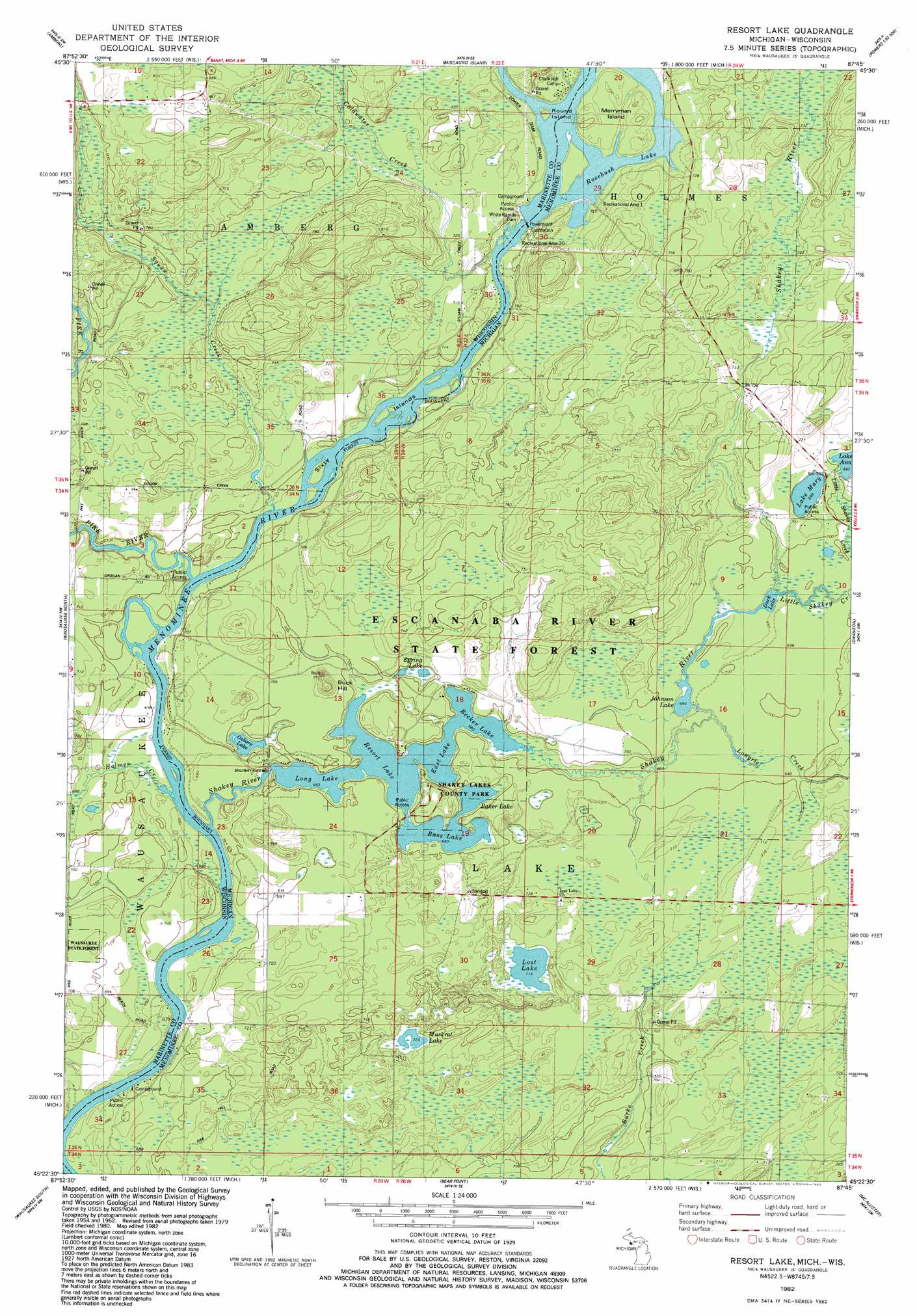
USGS Topo Quad 45087d7 - 1:24,000 scale
| Topo Map Name: | Resort Lake |
| USGS Topo Quad ID: | 45087d7 |
| Print Size: | ca. 21 1/4" wide x 27" high |
| Southeast Coordinates: | 45.375° N latitude / 87.75° W longitude |
| Map Center Coordinates: | 45.4375° N latitude / 87.8125° W longitude |
| U.S. States: | MI, WI |
| Filename: | o45087d7.jpg |
| Download Map JPG Image: | Resort Lake topo map 1:24,000 scale |
| Map Type: | Topographic |
| Topo Series: | 7.5´ |
| Map Scale: | 1:24,000 |
| Source of Map Images: | United States Geological Survey (USGS) |
| Alternate Map Versions: |
Resort Lake MI 1982, updated 1983 Download PDF Buy paper map Resort Lake MI 2011 Download PDF Buy paper map Resort Lake MI 2014 Download PDF Buy paper map Resort Lake MI 2016 Download PDF Buy paper map |
1:24,000 Topo Quads surrounding Resort Lake
Dunbar Ne |
Pembine |
Faithorn |
Cunard |
Hermansville |
Town Corner Lake |
Amberg |
Miscauno Island |
Banat |
Nadeau |
Athelstane |
Wausaukee North |
Resort Lake |
Swanson |
Stephenson |
Mount Tom |
Wausaukee South |
Bear Point |
Mcallister |
Wallace |
Crivitz |
Loomis |
Porterfield |
Chappee Rapids |
Birch Creek |
> Back to 45087a1 at 1:100,000 scale
> Back to 45086a1 at 1:250,000 scale
> Back to U.S. Topo Maps home
Resort Lake topo map: Gazetteer
Resort Lake: Dams
Squaw Creek 2WP1486 Dam elevation 215m 705′White Rapids Dam elevation 220m 721′
White Rapids Dam elevation 216m 708′
Resort Lake: Forests
Wausaukee State Forest elevation 217m 711′Resort Lake: Islands
Merryman Island elevation 222m 728′Round Island elevation 222m 728′
Sixty Islands elevation 210m 688′
Resort Lake: Lakes
Baker Lake elevation 208m 682′Bass Lake elevation 208m 682′
Becher Lake elevation 208m 682′
Duck Lake elevation 209m 685′
East Lake elevation 208m 682′
Johnson Lake elevation 209m 685′
Lake Ann elevation 211m 692′
Lake Mary elevation 213m 698′
Long Lake elevation 208m 682′
Lost Lake elevation 218m 715′
Muskrat Lake elevation 221m 725′
Osborn Lake elevation 209m 685′
Resort Lake elevation 208m 682′
Spring Lake elevation 211m 692′
Resort Lake: Parks
Shakey Lakes County Park elevation 215m 705′Resort Lake: Reservoirs
10 Reservoir elevation 215m 705′Rosebush Lake elevation 220m 721′
Rosebush Lake elevation 219m 718′
Shakey Lakes elevation 209m 685′
Resort Lake: Streams
Coldwater Creek elevation 213m 698′Holmes Creek elevation 207m 679′
Little Shakey Creek elevation 210m 688′
Longrie Creek elevation 209m 685′
Pike River elevation 210m 688′
Rosebush Creek elevation 219m 718′
Shakey River elevation 207m 679′
Squaw Creek elevation 210m 688′
Resort Lake: Summits
Buck Hill elevation 234m 767′Resort Lake digital topo map on disk
Buy this Resort Lake topo map showing relief, roads, GPS coordinates and other geographical features, as a high-resolution digital map file on DVD: