Wausaukee North Topo Map Wisconsin
To zoom in, hover over the map of Wausaukee North
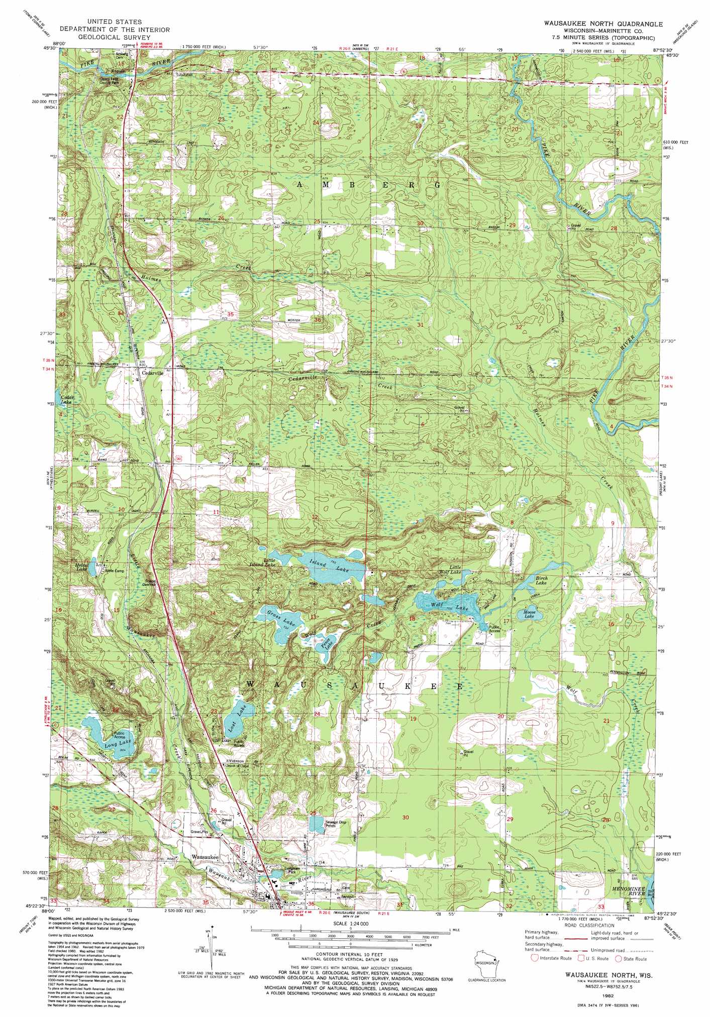
USGS Topo Quad 45087d8 - 1:24,000 scale
| Topo Map Name: | Wausaukee North |
| USGS Topo Quad ID: | 45087d8 |
| Print Size: | ca. 21 1/4" wide x 27" high |
| Southeast Coordinates: | 45.375° N latitude / 87.875° W longitude |
| Map Center Coordinates: | 45.4375° N latitude / 87.9375° W longitude |
| U.S. States: | WI, MI |
| Filename: | o45087d8.jpg |
| Download Map JPG Image: | Wausaukee North topo map 1:24,000 scale |
| Map Type: | Topographic |
| Topo Series: | 7.5´ |
| Map Scale: | 1:24,000 |
| Source of Map Images: | United States Geological Survey (USGS) |
| Alternate Map Versions: |
Wausaukee North WI 1982, updated 1983 Download PDF Buy paper map Wausaukee North WI 2011 Download PDF Buy paper map Wausaukee North WI 2013 Download PDF Buy paper map Wausaukee North WI 2016 Download PDF Buy paper map |
1:24,000 Topo Quads surrounding Wausaukee North
Dunbar |
Dunbar Ne |
Pembine |
Faithorn |
Cunard |
Twelvefoot Falls |
Town Corner Lake |
Amberg |
Miscauno Island |
Banat |
Lehman Lake |
Athelstane |
Wausaukee North |
Resort Lake |
Swanson |
High Falls Reservoir |
Mount Tom |
Wausaukee South |
Bear Point |
Mcallister |
White Potato Lake |
Crivitz |
Loomis |
Porterfield |
Chappee Rapids |
> Back to 45087a1 at 1:100,000 scale
> Back to 45086a1 at 1:250,000 scale
> Back to U.S. Topo Maps home
Wausaukee North topo map: Gazetteer
Wausaukee North: Falls
Daves Falls elevation 254m 833′Wausaukee North: Lakes
Birch Lake elevation 218m 715′Fence Lake elevation 223m 731′
Grass Lake elevation 223m 731′
Helen Lake elevation 251m 823′
Island Lake elevation 230m 754′
Little Island Lake elevation 230m 754′
Little Wolf Lake elevation 218m 715′
Long Lake elevation 245m 803′
Lost Lake elevation 233m 764′
Moose Lake elevation 215m 705′
Wolf Lake elevation 216m 708′
Wausaukee North: Parks
Daves Falls County Park elevation 258m 846′Evergreen Park elevation 231m 757′
Wausaukee North: Populated Places
Cedarville elevation 254m 833′Wausaukee North: Streams
Cedarville Creek elevation 225m 738′Little Wausaukee Creek elevation 216m 708′
Wolf Creek elevation 207m 679′
Wausaukee North digital topo map on disk
Buy this Wausaukee North topo map showing relief, roads, GPS coordinates and other geographical features, as a high-resolution digital map file on DVD: