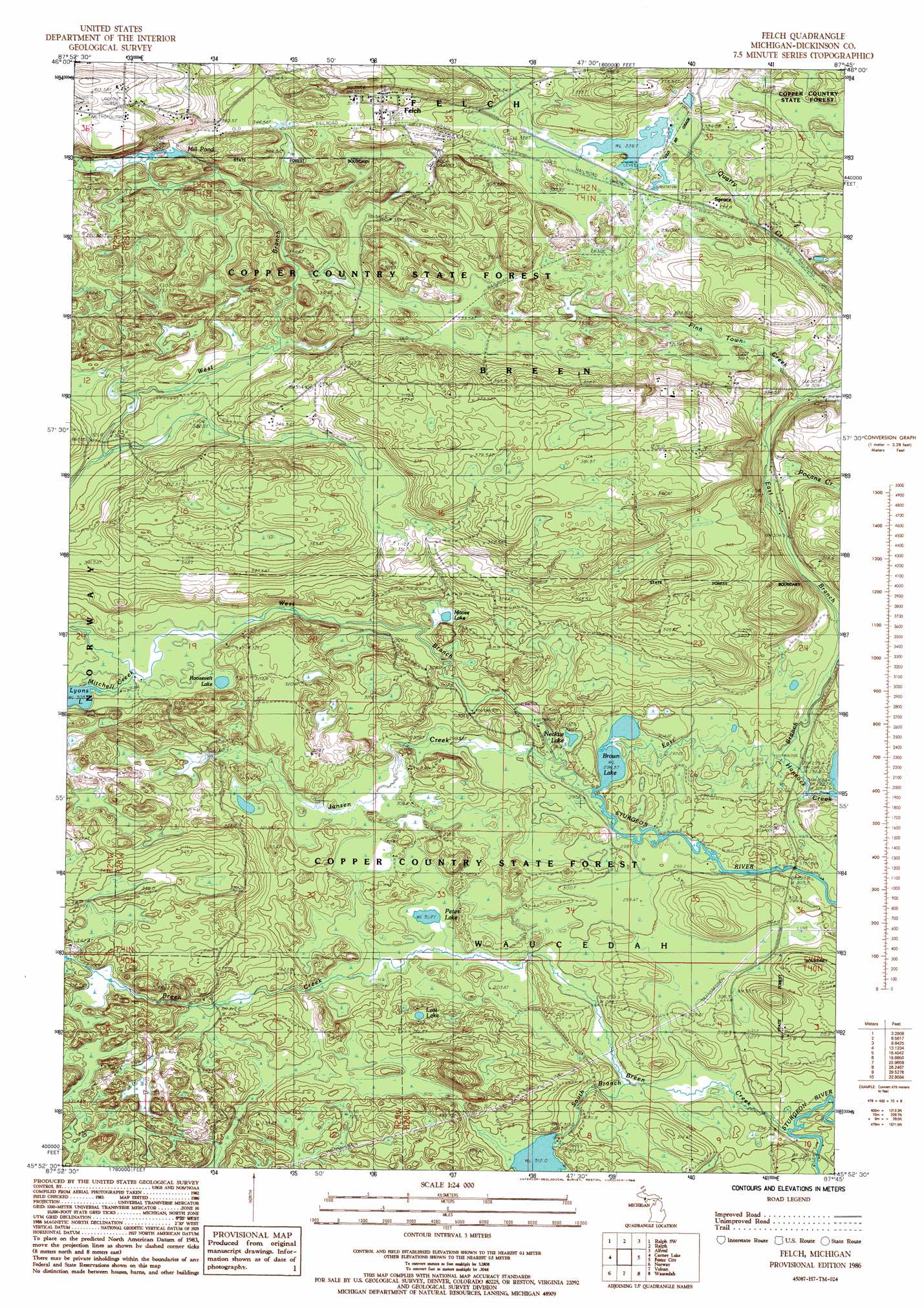
Felch Topo Map Michigan
To zoom in, hover over the map of Felch
USGS Topo Quad 45087h7 - 1:24,000 scale
| Topo Map Name: | Felch |
| USGS Topo Quad ID: | 45087h7 |
| Print Size: | ca. 21 1/4" wide x 27" high |
| Southeast Coordinates: | 45.875° N latitude / 87.75° W longitude |
| Map Center Coordinates: | 45.9375° N latitude / 87.8125° W longitude |
| U.S. State: | MI |
| Filename: | o45087h7.jpg |
| Download Map JPG Image: | Felch topo map 1:24,000 scale |
| Map Type: | Topographic |
| Topo Series: | 7.5´ |
| Map Scale: | 1:24,000 |
| Source of Map Images: | United States Geological Survey (USGS) |
| Alternate Map Versions: |
Felch MI 1986, updated 1986 Download PDF Buy paper map Felch MI 2011 Download PDF Buy paper map Felch MI 2014 Download PDF Buy paper map Felch MI 2016 Download PDF Buy paper map |
1:24,000 Topo Quads surrounding Felch
Channing |
Ralph Nw |
Ralph Ne |
Northland Nw |
Northland Ne |
Sagola |
Ralph Sw |
Ralph |
Alfred |
Northland |
Randville |
Carney Lake |
Felch |
Foster City |
Helps |
Iron Mountain |
Norway |
Vulcan |
Waucedah |
Vega |
Dunbar Ne |
Pembine |
Faithorn |
Cunard |
Hermansville |
> Back to 45087e1 at 1:100,000 scale
> Back to 45086a1 at 1:250,000 scale
> Back to U.S. Topo Maps home
Felch topo map: Gazetteer
Felch: Falls
Lower Mill Pond Falls elevation 330m 1082′Upper Mill Pond Falls elevation 332m 1089′
Felch: Lakes
Brown Lake elevation 297m 974′Lost Lake elevation 309m 1013′
Lyons Lake elevation 305m 1000′
Mill Pond elevation 354m 1161′
Moose Lake elevation 306m 1003′
Necktie Lake elevation 299m 980′
Petes Lake elevation 302m 990′
Roosevelt Lake elevation 308m 1010′
Felch: Mines
Calumet Mine elevation 352m 1154′Felch: Populated Places
Felch elevation 367m 1204′Spruce elevation 337m 1105′
Felch: Post Offices
Felch Post Office elevation 365m 1197′Felch: Reservoirs
Hancock Creek Flowage elevation 302m 990′Felch: Streams
Breen Creek elevation 294m 964′East Branch Sturgeon River elevation 297m 974′
Finn Town Creek elevation 309m 1013′
Hancock Creek elevation 299m 980′
Jansen Creek elevation 297m 974′
Pocans Creek elevation 306m 1003′
Quarry Creek elevation 314m 1030′
South Branch Breen Creek elevation 297m 974′
West Branch Sturgeon River elevation 297m 974′
Felch digital topo map on disk
Buy this Felch topo map showing relief, roads, GPS coordinates and other geographical features, as a high-resolution digital map file on DVD: