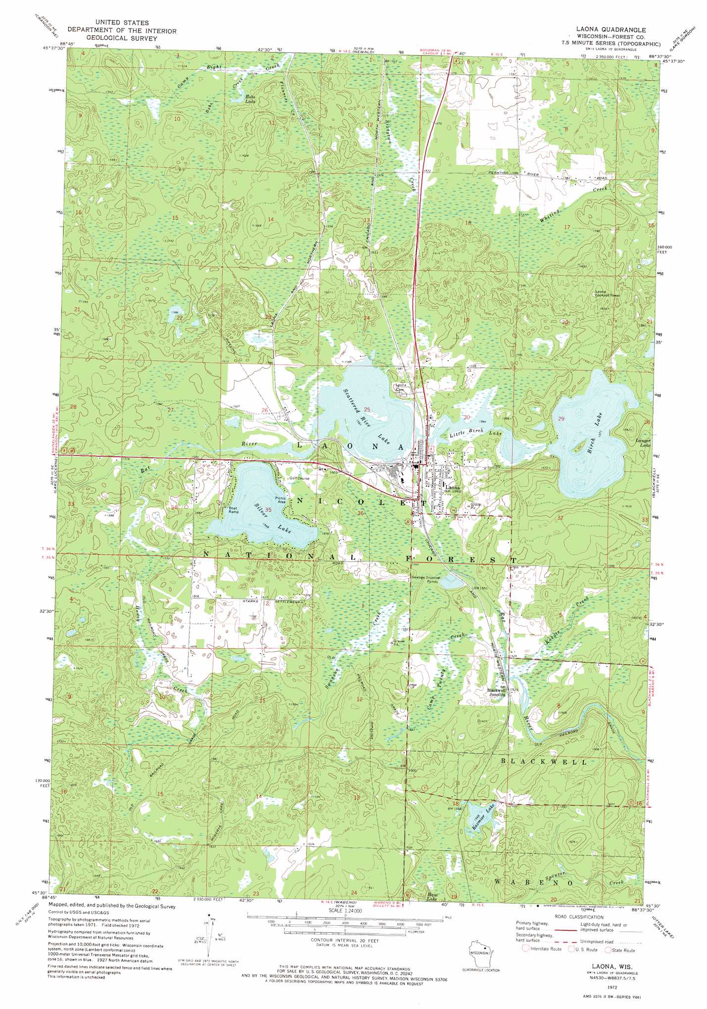
Laona Topo Map Wisconsin
To zoom in, hover over the map of Laona
USGS Topo Quad 45088e6 - 1:24,000 scale
| Topo Map Name: | Laona |
| USGS Topo Quad ID: | 45088e6 |
| Print Size: | ca. 21 1/4" wide x 27" high |
| Southeast Coordinates: | 45.5° N latitude / 88.625° W longitude |
| Map Center Coordinates: | 45.5625° N latitude / 88.6875° W longitude |
| U.S. State: | WI |
| Filename: | o45088e6.jpg |
| Download Map JPG Image: | Laona topo map 1:24,000 scale |
| Map Type: | Topographic |
| Topo Series: | 7.5´ |
| Map Scale: | 1:24,000 |
| Source of Map Images: | United States Geological Survey (USGS) |
| Alternate Map Versions: |
Laona WI 1972, updated 1974 Download PDF Buy paper map Laona WI 2011 Download PDF Buy paper map Laona WI 2013 Download PDF Buy paper map Laona WI 2015 Download PDF Buy paper map |
| FStopo: | US Forest Service topo Laona is available: Download FStopo PDF Download FStopo TIF |
1:24,000 Topo Quads surrounding Laona
Alvin Sw |
Alvin Se |
Long Lake |
Long Lake Se |
Florence Sw |
Argonne |
Crandon Ne |
Newald |
Lake Gordon |
Armstrong Creek |
Crandon |
Lake Lucerne |
Laona |
Blackwell |
Goodman Sw |
Mole Lake |
Roberts Lake |
Wabeno |
Otter Lake |
Mccaslin Mountain |
Pickerel |
Lily |
Reservoir Pond |
Townsend |
Wheeler Lake |
> Back to 45088e1 at 1:100,000 scale
> Back to 45088a1 at 1:250,000 scale
> Back to U.S. Topo Maps home
Laona topo map: Gazetteer
Laona: Airports
Heritage Acres Airport elevation 485m 1591′Laona: Dams
Connor Forest Industries 1897C211 Dam elevation 476m 1561′Laona: Forests
Nicolet National Forest elevation 470m 1541′Laona: Lakes
Birch Lake elevation 480m 1574′Bobs Lake elevation 469m 1538′
Kazmier Lake elevation 478m 1568′
Little Birch Lake elevation 477m 1564′
Scattered Rice Lake elevation 476m 1561′
Silver Lake elevation 478m 1568′
Spring Pond elevation 474m 1555′
Laona: Populated Places
Blackwell Junction elevation 464m 1522′Laona elevation 480m 1574′
Laona: Reservoirs
Scattered Rice Lake 38 elevation 476m 1561′Laona: Streams
Bobs Creek elevation 469m 1538′Camp Twenty Creek elevation 462m 1515′
Flanners Creek elevation 467m 1532′
Honey Creek elevation 479m 1571′
Kokots Creek elevation 462m 1515′
Swan Creek elevation 449m 1473′
Swanson Creek elevation 469m 1538′
Laona digital topo map on disk
Buy this Laona topo map showing relief, roads, GPS coordinates and other geographical features, as a high-resolution digital map file on DVD: